BufordWX
Member
Blue Norther , FTW! Take lots of pics! I’ll take some of my cloud deck tomorrow!Gotta love the plains! It was 71 yesterday ?
That's tomorrow night but yeah tonight's still goes below freezing by morning
Same for our '94 Ice Storm. 70's or so day before.It should be noted that warmth before a snowstorm is not unusual here. It also hit 70 before the February 2011(ironically around the same dates) blizzard which is the record here at 14 inches. This storm has some similarities tbh it also went and was a big blizzard up in the Midwest I believe
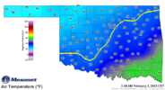
Here we are at 09z and temperatures just hit 32 at OKC and about to go below freezing in Tulsa. Probably gonna get some freezing drizzle in spots through the morning.One thing I am interested in watching tomorrow is how the front is progressing. Right now most models show OKC and Tulsa getting below freezing by 12z-15z, but I wouldn’t be surprised if that actually happens a few hours earlier like around 09z. Last year played out similarly as the cold air filtered in several hours earlier then originally thought. This could mean earlier onset of freezing rain Wednesday morning.

Dude. That is awesome. You have to be excited. I have family that lives upstream from you in O'Fallon, MO, where we lived for 3.5 years. They have been due in that area for a while as well for a big dog like this.From the Tulsa AFD this is gonna be insane
Forecast
soundings within the heavier frontogenetically forced band of snow
show a very deep DGZ (in excess of 3000ft) in tandem with
negative omega fields. This screams very large (and wet initially)
snowflakes that will come down very hard at times by late this
evening. 1 per hour snowfall rates are expected with brief 2
per hour rates very possible late in the evening and especially
as we go into the overnight hours. This will result in rapid
snowfall accumulations starting as early as this evening.
Dude. That is awesome. You have to be excited. I have family that lives upstream from you in O'Fallon, MO, where we lived for 3.5 years. They have been due in that area for a while as well for a big dog like this.
Pulling for ya Brent. I hope you get absolutely buried.Yeah this has potential to be the biggest snowstorm I've seen since I was old enough to understand it certainly ? I was too young and barely remember 93 in Bama. Nothing else rcomes close to the ceiling on this one
Hey, I was in BAMA for the '93 Blizzard as well. We lived in the Huffman area back then and I remember Jim Skinner Ford's roof collapsing on their showroom floor. Ironically, we moved to O'Fallon MO later that year.Yeah this has potential to be the biggest snowstorm I've seen since I was old enough to understand it certainly ? I was too young and barely remember 93 in Bama. Nothing else rcomes close to the ceiling on this one
Hey, I was in BAMA for the '93 Blizzard as well. We lived in the Huffman area back then and I remember Jim Skinner Ford's roof collapsing on their showroom floor. Ironically, we moved to O'Fallon MO later that year.

Y'all sooners better post some good pics for us losers on the east coast

Dang, this is crazy. Gonna be a fun day!
Shift southeast vs 06Z.
Oh boy freezing rain..yuck
