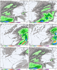
Kind of surprised it wasn’t a little better than that…but that was a good run.Ended up pretty similar in lots of places compared to 12z.
View attachment 170140

Kind of surprised it wasn’t a little better than that…but that was a good run.Ended up pretty similar in lots of places compared to 12z.
View attachment 170140

It definitely seemed to be tracking better up through hr 42. We’ve often seen times where a dampening out southern wave will hold on a little stronger and longer than the models say. It’s one of the reasons we get a bit juicier system than modeled even with similar placed features.Kind of surprised it wasn’t a little better than that…but that was a good run.
View attachment 170142
For NC. Further west it keeps going SW and colder.Regardless the GFS has stopped the SE trend…for now.
I’m cringing at the thought of the 18z Euro
View attachment 170143
I am terrified of the inevitable cutoff that is probably gonna result in a lot of people in Wake County (possibly me) being very disappointed.That band that runs through the Piedmont into Raleigh and East is a interesting and emerging feature on the GFS View attachment 170144
For NC. Further west it keeps going SW and colder.
Those bands almost always verify further NW too.I am terrified of the inevitable cutoff that is probably gonna result in a lot of people in Wake County (possibly me) being very disappointed.
This. I am happy with this. Gets my backyard in the action, and keeps the east coast peeps happy. If we can get it to creep down to Bham to keep my Bama homies happy, icing on the cake.Regardless the GFS has stopped the SE trend…for now.
I’m cringing at the thought of the 18z Euro
View attachment 170143
Yep you've got that, plus you've got saturation all the way up to 200mb for several hours Wednesday morning. Plus the better jet dynamics helping with lift for a little while.Some things just don’t make sense, and the GFS QPF depiction makes sense with the broad warm air advection regime View attachment 170141
Its orientation keeps changing to more SW-NE, heights rising ahead of the storm...For NC. Further west it keeps going SW and colder.
I'd like to see some better trends through tomorrow morning's model runs before I allow myself to excited.Literally 10-15 miles further south on the gfs gets the southern suburbs of BHM in on the game but I’m not buying it. I’d feel dang good in northern Alabama. Feel like Cullman north could get a surprise
The thing I generally like at this point is that the thermal profiles for our area look pretty solid across all the modeling at this point, so all we need is a touch over .1 to get a solid little something outta this thing. I may be crazy, but the way this thing is setting up sure looks like .1+ to me at this point.I'd like to see some better trends through tomorrow morning's model runs before I allow myself to excited.
Hey Lick! What about Forest City. What are you thinking. A inch or two maybe?Its orientation keeps changing to more SW-NE, heights rising ahead of the storm...
Licks new call ignore the 2 foot predictions from yesterday
Wake county will ride the line, Wake Forest still the jackpot here, Zebulon eating more sleet now so Ill go 4-6 inches Wake Forest, almost all snow, 2-4 inches Zebulon half snow half sleet. my friends in southern wake don't fret you'll get 2 inches, mostly sleet. RDU same as Wake Forest.
Metwannabe is getting 6-8 , jackpot will be a bit northeast of him, if trends keep going like the nam has done he will also ride the line
Shane, same as southern wake
I think charlotte will eek out 1-2 inches from this and maybe if they are lucky another inch from Thursday
That is where I think we stand now
Literally 10-15 miles further south on the gfs gets the southern suburbs of BHM in on the game but I’m not buying it. I’d feel dang good in northern Alabama. Feel like Cullman north could get a surprise
My unprofessional opinion is T-1 right now your way, these are the trends you want to keep seeing on models though so that upper end is realized, then perhaps you could get a couple inches.Hey Lick! What about Forest City. What are you thinking. A inch or two maybe?
drying or just more mixing/shifting of orientation?Major positive trends for Northern MS/AL/GA/SC and western NC on the GEFS.
Bad trends for Virginia and Eastern NC though.View attachment 170156
Think we are just scratching and clawing to get a light snow on the ground here with the weak southern wave that is translating west to east. The coastal blow up or mini-blowup is likely a thing for the eastern 1/2 of the state. Improvements would most likely come from a slight sharpening of the southern wave. That’s probably the best we can do at this point. I think the GFS looks like a reasonable forecast for us. Always a chance this could tick warmer, but there are limits to that based on how weak this is overall aloftNam looks like it blows up the coastal and gets the comma head to just reach out and tap the clt area. That would be great but I’m having a hard time believing that with past experience. But maybe the roaring jet would enhance precip? Heavy frotogenesis in the clt area?
Stupid Nam has me somewhat interested again, but I bet the RGEM is more right. My current belief is whatever we get will be from the overrunning, and not the coastal.
Looks like mostly mixing to me.drying or just more mixing/shifting of orientation?
A combination of both for Eastern NC. Some members mixing, some members not as robust with the coastal development.drying or just more mixing/shifting of orientation?
No way Central Mississippi is getting 6" lol.Rap is basically a widespread 1-1.5 for the overrunning stuff and then more for the eastern areas with the coastal. Not unrealistic tbh, and this could go either way View attachment 170159
I will have a map out tonight. I have way more in the mountains than you.View attachment 170162
This is a tough one. I'm already not feeling great about my NW NC numbers so I'm sure I'll be scrambling to adjust things before my final forecast tomorrow.
To only manage an inch of snowfall out of this model depiction is extremely disappointing lol. Sprawling 1055 high pushing in from Montana with a gulf low south of Louisiana and no lakes low, and I get an inch of snowView attachment 170163
Rap is basically a widespread 1-1.5 for the overrunning stuff and then more for the eastern areas with the coastal. Not unrealistic tbh, and this could go either way View attachment 170159
I swear the rap is one of those models where the precip depiction and shading over exaggerates intensity. Always looks like a heavy snow storm just to find the map prints flurriesRap is basically a widespread 1-1.5 for the overrunning stuff and then more for the eastern areas with the coastal. Not unrealistic tbh, and this could go either way View attachment 170159
