-
Hello, please take a minute to check out our awesome content, contributed by the wonderful members of our community. We hope you'll add your own thoughts and opinions by making a free account!
You are using an out of date browser. It may not display this or other websites correctly.
You should upgrade or use an alternative browser.
You should upgrade or use an alternative browser.
Pattern Failbruary Thread
- Thread starter SD
- Start date

Not that much difference in the GFS. 
HSVweather
Member


Considering the GFS's record at H5 5-6 days out, I'm not that intrigued.
whatalife
Moderator
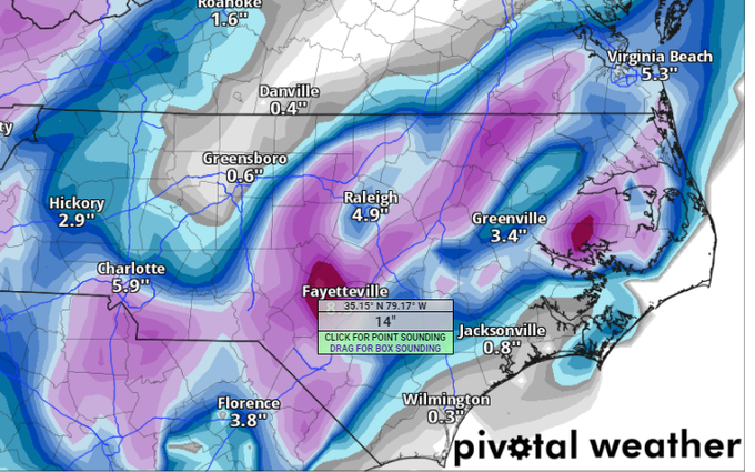
Well this is going to suck being in the bull’s-eye 5-6 days out. ?
Dang even Pensacola gets in the action!Well this is going to suck being in the bull’s-eye 5-6 days out. ?View attachment 113053
Considering the GFS's record at H5 5-6 days out, I'm not that intrigued.
Does that mean you want to start the thread?
Anyway, this goes to show that if we can just get the moisture and cold to better meet up during this prime time climo period of mid Feb, we may get something big! We have the +PNA and prime climo on our side at least.
D
Deleted member 609
Guest
??

I'll take that and go into Spring. That said not far from a much bigger bomb.
Stephenb888
Member
Crazy thing is seeing this under 7 days, we all would be getting really excited if this was the good old days… but now things are so strange. Idk if I’d even feel comfortable 2 days out with this look anymore.Probably gone tomorrow. But not impossible ?
GFS wave pass is as good as we can do in this setup me thinks. The initial southern stream piece moving NE out of the gulf is likely to be too warm (much like today), but a snowier version of last weekend’s storm with the northern stream dropping down would be the high bar.
Downeastnc
Member
Pretty strong signal for winter weather on Valentines day.....most models have the storm to some degree. Only 7 days or so away as well.....
rburrel2
Member
Crazy the GFS just spat out a solution that's way better than any of it's ensemble members have shown for this storm. 00z Ukmet looks pretty similar too, but not quite as cutoff/amped. fingers crossed some of the ensemble members start jumping on board tonight.
CMC although was a miss was violently close and a much better look from its 12z run
These would be some dynamic snow squalls imbedded .. fun stuff and in the mid 20s during the peak 
UKMet was indeed similar to the GFS, just not as deep with the trough. UKMet has 558 height line in N FL while GFS has 552 ht line there. UKMet was a touch deeper this run thoughCrazy the GFS just spat out a solution that's way better than any of it's ensemble members have shown for this storm. 00z Ukmet looks pretty similar too, but not quite as cutoff/amped. fingers crossed some of the ensemble members start jumping on board tonight.
Clem282340
Member
What does the gefs looking like for this storm
rburrel2
Member
GEFS is a slight improvement on the mean snowfall map. Still not very impressed with this system though. One or two members are similar to the Op, the rest are weaker or hang the energy back .
Still almost all are within spitting distance of a bigger storm just some missed phasing and stuff that clearly won’t be worked out at this range .. love seeing the pieces all on the board thoughGEFS is a slight improvement on the mean snowfall map. Still not very impressed with this system though. One or two members are similar to the Op, the rest are weaker or hang the energy back .
rburrel2
Member
The good thing is the models (Ukmet,CMC,ICON,GFS) seem to have converged much closer together on the evolution of the system. And the edge of those goal posts of that evolution include the chance for a major winter storm for us. Even the center of the goal posts produce a decent event for some people on the board.
Would be really, really huge tonight if the Euro could spit out a GFS-like solution.
Would be really, really huge tonight if the Euro could spit out a GFS-like solution.
NCWeatherhound
Member
Looks like the Ukie is leaning toward the GFS in the early going. Not as amped, and, of course, it doesn't yet go out to the time frame where the GFS is walloping folks in this neck of the woods. Think of it as what could be ... and wait until things settle out. But it's hard to sleep when the model plants this on your doorstep.

Really liking the setup around valentines day.. things are falling into place at the right time. Ensembles aren't really on board yet, though.
Keep this in mind: ATL’s most prime big SN/IP climo back to 1879 based on number of storms concentrated in one week is 2/10-16 with 9 major storms. This storm on the 0Z GFS is progged to hit ATL smack dab in the middle of that period (2/13). At ATL and much of the SE, a +PNA is one of the most favorable, if not the most favorable index, for a big one (back to 1950, the start of that daily stat). These don’t necessarily mean there will be a storm at all, but they’re encouraging to keep in mind for the chances.
Other big storms during that week at ATL include 1934, 2010, and 2014 among others. 1934 is a similar ENSO analog by the way.
Other big storms during that week at ATL include 1934, 2010, and 2014 among others. 1934 is a similar ENSO analog by the way.
Last edited:
dsaur
Member
Yeah, I haven't been unusually cold, but I haven't see tshirt weather either. With some timing I'd be cold enough a lot.The past two days had highs only in the 40s here, the first time this winter for two days in a row that cold.
stephend122080
Member
00z ECMWF...looks like the phase was later offshore.

Sent from my SM-A115U1 using Tapatalk

Sent from my SM-A115U1 using Tapatalk
stephend122080
Member
6z GFS still produces snow for a good chunk of the south


Sent from my SM-A115U1 using Tapatalk


Sent from my SM-A115U1 using Tapatalk
Blue_Ridge_Escarpment
Member
Pretty large increase on the 6Z GEFS.
HSVweather
Member

HurricaneSolomon
Member
- Joined
- Dec 6, 2021
- Messages
- 154
- Reaction score
- 276
Maybe, just maybe instead of a “Failbruary” we can have a “Triumphbruary”. Yes, I googled to find the best opposite of “fail” here. It’s a reach I know...
Sent from my iPad using Tapatalk
Sent from my iPad using Tapatalk
Yeah that's what I've been waiting for it's hard to get excited with the op with no ensb support but gefs looks better no doubt.Pretty large increase on the 6Z GEFS.
stephend122080
Member
With the right amount of timing and degree of phasing, a large part of the south could get in on this. A few members have snow as far west as eastern TX. Still a ways to go and noting the potential, nothing set in stone yet.
Sent from my SM-A115U1 using Tapatalk
Jimmy Hyprocisy gonna love # 1. I'll Take # 18.
Approaching the magical 120 Hr out point latter today from start time. Hopefully the consensus keeps building through 12z today.
Approaching the magical 120 Hr out point latter today from start time. Hopefully the consensus keeps building through 12z today.
NBAcentel
Member
Best gefs run yet 
Looking better and something I've noticed over the years is there seems to be storms on or about specific dates throughout winter like the Jan 15-20 and always around Valentine's day something I've been wanting to talk with our bookkeeper Larry about ?Best gefs run yet View attachment 113062
iGRXY
Member
Several GEFS members picking up on the possibility gives me more hope than I originally had. We also tend to have our best snows on the heels of an upcoming pattern change as well. One last hooray before the switch to more warmth.
L
Logan Is An Idiot 02
Guest
I personally would rather have the euro and eps on our side. I haven’t seen one EPS post on here.Several GEFS members picking up on the possibility gives me more hope than I originally had. We also tend to have our best snows on the heels of an upcoming pattern change as well. One last hooray before the switch to more warmth.
I smell a new thread soon. The W SE is already being threatened by this in only 4 days (2/12) and the E SE in only 5 days (2/13).Looking better and something I've noticed over the years is there seems to be storms on or about specific dates throughout winter like the Jan 15-20 and always around Valentine's day something I've been wanting to talk with our bookkeeper Larry about ?
This storm is threatening ATL on 2/13. ATL has had a whopping NINE major SN/IP within 3 days of 2/13 making it the most concentrated major SN/IP climo of the entire winter:
1) 2/12-13/2014: cold neutral ENSO/ -1.1 PNA/+0.8 NAO/+0.9 AO/MJO COD
2) 2/12/2010: waning strong El Nino/+0.7 PNA/-1.0 NAO/-4.8 AO/MJO phase 8
3) 2/15/1958: strong El Nino/+1.2 PNA/-0.2 NAO/-1.9 AO
4) 2/10/1934: waning moderate La Nina similar to now
5) 2/14-15/1902: cold neutral ENSO
6) 2/11-12/1899: weak La Nina
7) 2/15-16/1895: waning weak La Nina
8) 2/11-12/1895: waning weak La Nina
9) 2/15/1885: waning weak El Nino
**And these are just the big storms as there are plenty of not as big events also during this period.
Last edited:
L
Logan Is An Idiot 02
Guest
Would you not want to see the EPS on board before we start a thread?I smell a new thread soon. The W SE is already being threatened by this in only 4 days (2/12) and the E SE in only 5 days (2/13).
This storm is threatening ATL on 2/13. ATL has had a whopping NINE major SN/IP within 3 days of 2/13 making it the most concentrated major SN/IP climo of the entire winter:
1) 2/12-13/2014: cold neutral ENSO/ -1.1 PNA/+0.8 NAO/+0.9 AO/MJO COD
2) 2/12/2010: waning strong El Nino/+0.7 PNA/-1.0 NAO/-4.8 AO/MJO phase 8
3) 2/15/1958: strong El Nino/+1.2 PNA/-0.2 NAO/-1.9 AO
4) 2/10/1934: waning moderate La Nina
5) 2/14-15/1902: cold neutral ENSO
6) 2/11-12/1899: weak La Nina
7) 2/15-16/1895: waning weak La Nina
8) 2/11-12/1895: waning weak La Nina
9) 2/15/1885: waning weak El Nino
Would you not want to see the EPS on board before we start a thread?
That would be nice to see.