First of many late winter & spring time wedges. We max on these Feb,March, April, May the most it seems. Helps keep severe in check a lot of times around here fortunately

All i'm saying here, is that it's Ens vs Ops right now. BOTH GFS and Euro Operational models do not agree with their Ens. It gives me pause.Western ridge this past jan and being modeled again is on roids, ensembles look great View attachment 112538View attachment 112541View attachment 112540


We were bn for precip in jan for CLT yet it wax the snowiest jan in a while,
Look about dead on to me. Honestly really good agreement.All i'm saying here, is that it's Ens vs Ops right now. BOTH GFS and Euro Operational models do not agree with their Ens. It gives me pause.
Euro @ 240
View attachment 112555
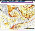
06z GFS @ 240
View attachment 112556


Just really unfortunate that’s it’s being wasted with no precipitation. Maybe something will pop up but it looks cold and dryAleutian low trending deeper and stronger and further east ? Good luck getting warm ?View attachment 112592View attachment 112593
Gotta get cold to snowJust really unfortunate that’s it’s being wasted with no precipitation. Maybe something will pop up but it looks cold and dry
Just really unfortunate that’s it’s being wasted with no precipitation. Maybe something will pop up but it looks cold and dry


Looking like a Rex block! Locking in the cold. Great for SE winter storms! I’d get excited if I live in GA, SC, NCAleutian low trending deeper and stronger and further east ? Good luck getting warm ?View attachment 112592View attachment 112593
That’s true. We shall see. I hope a stork nails the entire southeast. Outside of the Carolinas it’s been a bad winter for snowGotta get cold to snow
Tennessee has had a good bit of snow this winter.That’s true. We shall see. I hope a stork nails the entire southeast. Outside of the Carolinas it’s been a bad winter for snow

15 run temperature trend loop for hr288 on GEFS


Sheesh this is scary similarGEFS 5 day pattern average for Feb 10-15 vs. Jan 13-31 pattern average
Carbon copy and we know what happened. I fully expect some southern energy to slide across the SE sometime in the next couple of weeks and cause mischief.GEFS 5 day pattern average for Feb 10-15 vs. Jan 13-31 pattern average

I haven't been below 20 yet, and even the worst winter here recently I got a 17 one night.Spring is around the corner in the SE per the 12Z GFS!
View attachment 112584
Actually, ensemble means have been suggesting one of the coldest airmasses of the season to date plunging into the SE near midmonth.
Like i said bruh, take my moneyNot too worried about precip. Cold signal is pretty good. We'll get a few waves dropping in from time to time. QC in trouble

Tennessee has had a good bit of snow this winter.
Depends if we can wave break and flex that weak -nao signature. I'd lean eps mainly because I'm an eps truther but we have seen it water down small details around D10 in the mean more than once this winter and then have to "trend" toward the gefsWho you got...GEFS or EPS. Day 8-9...quite a difference with temps.
View attachment 112611View attachment 112612
Who you got...GEFS or EPS. Day 8-9...quite a difference with temps.
View attachment 112611View attachment 112612

Some EPS members hinting at playing around with some big time fire in this period.Well that is close to being interesting.


Editing to Add KBUY (Burlington, Ollie)Spot the gradient?
KINT (Smith Reynolds)
View attachment 112632
KGSO (Piedmont Triad)
View attachment 112633
View attachment 112631