- Joined
- Jan 23, 2021
- Messages
- 4,604
- Reaction score
- 15,203
- Location
- Lebanon Township, Durham County NC
What do you expect with Nina climatology?Sigh. Smells like a warm nose.
What do you expect with Nina climatology?Sigh. Smells like a warm nose.

One of the only Differences is, Dallas is gonna likely miss out on snow and get IP/ZRJust wow this may be a better signal for snow than last February had at this rate ?
View attachment 111680
One of the only Differences is, Dallas is gonna likely miss out on snow and get IP/ZR
Looks like your going to be right on the dividing line. You could get either heavy rain or freezing rain. Looks like all rain for meMemphis cautiously looking over the forecast going into next week. Here's a piece from their afternoon AFD:
Rain chances will increase Tuesday Night and into Wednesday as
the cold front eventually sinks into the Mid-South. PW`s will be
150 to 250 percent above normal for this time of year. Thus, the
threat for heavy rain will be possible with this system. In
addition, winter weather will be a concern. Arctic air will be
plunging in behind the front. The big question will be where
exactly will be the front located. There remains differences
amongst the models on where exactly the front will be as the front
is expected to slow its progression and possibly stall Wednesday
Night into Thursday as a SFC low develops over Texas and tracks
northeastward along the front. In addition, there are differences
in regards to timing of an upper trough moving into the region.
There is a scenario where the arctic air filters in but a shallow
warm layer remains just above the surface to produce freezing
rain. If the arctic air plunges in quicker, precipitation may turn
to all snow. Do expect at least a short period of snow on the
back edge of the precipitation Thursday afternoon into the evening
as the precipitation tapers off. However, too much uncertainty
during this time period to pinpoint what exactly will happen.
Mentioned freezing rain and snow in forecast for Wednesday Night
into Thursday. Stay tuned to the latest forecasts.
Pretty sure the euro control run might’ve had significant ice for 40N


Nothing wrong with that.

.png")

@Brent is gonna like the 00z GFS.View attachment 111695
Seems too good to be true ? still 3 days to go scares me ?
.png")
May have to go visit my maw in law right slap in the middle of that foot mean...A foot mean on the GEFS in Missouri!View attachment 111697
We tossA foot mean on the GEFS in Missouri!View attachment 111697

Dang, the Canadian has this sucker dragging on for 36-48 hoursView attachment 111698


This should be a big storm for our western folks. I would love to hear some analysis of it as it comes in.
geez man. You got an extra room over there? ??Good grief Canada. Lol


Oklahoma usually always has wild Winter weather and Tulsa is in a good location. It just a little late getting started this season.Thursday is increasingly looking snowy to me. The trend has been there all day in some form
It just shows the GFS has it's qualities... Pattern recognition and picking up storm signals in the long range is another.This was the GFS back on the 19th for February 4th at 384 hours. Interesting that it had this upcoming storm showing at that range.
View attachment 111707
Oklahoma usually always has wild Winter weather and Tulsa is in a good location. It just a little late getting started this season.


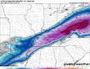
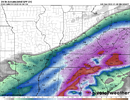
Have any images to share of the UKIE?The UKIE is just a massive winter storm for all of Arkansas, NW Miss and most of Tennessee and Kentucky. It and the Euro are in a camp, the GFS is in a camp and the Canadian is between them. The Euro has trended progressively away from first a Lakes cutter, now it's trending away from an Apps cutter.
These two, the snowfall map is where frozen falls, but it's not snow in most of Tennessee and Mississippi. Temps are 27-30 degrees with 850s above 0c, so it's a big ice or sleet event.Have any images to share of the UKIE?
If most of that is freezing rain it would certainly be lights out.These two, the snowfall map is where frozen falls, but it's not snow in most of Tennessee and Mississippi. Temps are 27-30 degrees with 850s above 0c, so it's a big ice or sleet event.