What did 1993 look like heading into March? I remember the storm but not what the weather was like in the preceeding weeks/months.
-
Hello, please take a minute to check out our awesome content, contributed by the wonderful members of our community. We hope you'll add your own thoughts and opinions by making a free account!
You are using an out of date browser. It may not display this or other websites correctly.
You should upgrade or use an alternative browser.
You should upgrade or use an alternative browser.
Pattern Fail or Fab February 2023 Pattern Thread
- Thread starter RBR71
- Start date
Flotown
Member
warmWhat did 1993 look like heading into March? I remember the storm but not what the weather was like in the preceeding weeks/months.
NoSnowATL
Member
Warm. it was a awful winter in Atlanta.What did 1993 look like heading into March? I remember the storm but not what the weather was like in the preceeding weeks/months.
Flotown
Member
i lived in talladega, al where we got 13 inches out if thst storm and it was in the seventies a few days before. believe the entire winter was fairly mildwarm
A+ winter afternoon
I lived on South Side in the Ham at that time. Was wearing shorts a few days before that storm.i lived in talladega, al where we got 13 inches out if thst storm and it was in the seventies a few days before. believe the entire winter was fairly mild
NoSnowATL
Member
What some forget was that we have severe weather before the snow arrived. We didn't have phones to pull up the radar so we figured it was a bust. Well when it switched to snow it was crazy.I lived on South Side in the Ham at that time. Was wearing shorts a few days before that storm.
Wedge prevents a pretty decent nc severe outbreak on the euro but would likely be rough in the deep south
Iceagewhereartthou
Member
Here's some winter

 www.ipcamlive.com
Embedding IP Camera Live Video Stream into web page - IPCamLive.com
Video streaming solution for IP camera to embed live video stream into web page
www.ipcamlive.com
I think most areas in the Southeast went nearly, or completely, snowless from 1991-1993, so it was a horrible winter. Charlotte’s longest streak of no accumulating snowfall on record came from 1991-1993, IIRC.What did 1993 look like heading into March? I remember the storm but not what the weather was like in the preceeding weeks/months.
For North Carolina folks, the winter of the Carolina Crusher was also terrible with the exception of the Crusher itself and a few days on either side of that one (we got a smaller event a few days before).
whatalife
Moderator
Looks fine to me. Let’s roll with it.
Yeah that ‘99-00 winter basically just had a perfect two weeks where the pattern was right and every threat produced. It’s seems that most years that see a huge storm in the Carolinas , that’s typically the only one of the season here. The biggest exception I can think of would have been ‘03-04 when there had been a significant storm in late January and then of course the big snowstorm the last few days of FebruaryI think most areas in the Southeast went nearly, or completely, snowless from 1991-1993, so it was a horrible winter. Charlotte’s longest streak of no accumulating snowfall on record came from 1991-1993, IIRC.
For North Carolina folks, the winter of the Carolina Crusher was also terrible with the exception of the Crusher itself and a few days on either side of that one (we got a smaller event a few days before).
Webberweather53
Meteorologist
The CFSv2 weeklies, GEFS extended, ECMWF weeklies, & CMC Extended all hint at one last gasp of winter in/around early March.
Other than that, zzzz
Other than that, zzzz
Webberweather53
Meteorologist
Yeah that ‘99-00 winter basically just had a perfect two weeks where the pattern was right and every threat produced. It’s seems that most years that see a huge storm in the Carolinas , that’s typically the only one of the season here. The biggest exception I can think of would have been ‘03-04 when there had been a significant storm in late January and then of course the big snowstorm the last few days of February
People really have no idea how much it actually used to snow around the Carolinas. Winters like 1999-00, 2003-04, 2017-18, etc. some think of as being good in modern times look pretty average when you put them against older years like 1898-99, 1935-36, 1959-60, 1979-80, etc.
What part of town were you in? We started as sleet never had any rain. We had several inches of snow by 8:30pm that night.What some forget was that we have severe weather before the snow arrived. We didn't have phones to pull up the radar so we figured it was a bust. Well when it switched to snow it was crazy.
NoSnowATL
Member
DecaturWhat part of town were you in? We started as sleet never had any rain. We had several inches of snow by 8:30pm that night.
NoSnowATL
Member
We had heavy rain and thunder . I don’t remember when it switched to snow but it was rain when I went to sleep and snowing like crazy when I woke up early in the morning.What part of town were you in? We started as sleet never had any rain. We had several inches of snow by 8:30pm that night.
I went to sleep with a lot of snow but woke up to the thunder and lightning thinking we'd gone over. I didn't know Thundersnow existed at the time.We had heavy rain and thunder . I don’t remember when it switched to snow but it was rain when I went to sleep and snowing like crazy when I woke up early in the morning.
I was in the SW NC mountains in 93. We did get a mid to late February snow of a few inches. 1st one of winter I beleive. Then the blizzard came. It was a cold several days afterwards with 0 degree nights, Tuckasegee River froze over completely.
January 2000 had best 10 day stretch of winter wx ever here In Randolph County. But both where warm and non eventfull outside those events. Not sure but beleive it was Early May of 1993 and it snowed 60 inches on Mt pisgah, like a foot in waynesville up through balsam Gap. Rode right through it. If it wasnt 93 it was 1992 or 1991.
January 2000 had best 10 day stretch of winter wx ever here In Randolph County. But both where warm and non eventfull outside those events. Not sure but beleive it was Early May of 1993 and it snowed 60 inches on Mt pisgah, like a foot in waynesville up through balsam Gap. Rode right through it. If it wasnt 93 it was 1992 or 1991.
It was early May of 1992. I was camping with my Dad and a couple of his buddies outside of Maggie Valley and we had no idea that snow was coming.I was in the SW NC mountains in 93. We did get a mid to late February snow of a few inches. 1st one of winter I beleive. Then the blizzard came. It was a cold several days afterwards with 0 degree nights, Tuckasegee River froze over completely.
January 2000 had best 10 day stretch of winter wx ever here In Randolph County. But both where warm and non eventfull outside those events. Not sure but beleive it was Early May of 1993 and it snowed 60 inches on Mt pisgah, like a foot in waynesville up through balsam Gap. Rode right through it. If it wasnt 93 it was 1992 or 1991.
- Joined
- Jan 23, 2021
- Messages
- 4,604
- Reaction score
- 15,203
- Location
- Lebanon Township, Durham County NC
13-14 would qualify too, if I remember correctly.Yeah that ‘99-00 winter basically just had a perfect two weeks where the pattern was right and every threat produced. It’s seems that most years that see a huge storm in the Carolinas , that’s typically the only one of the season here. The biggest exception I can think of would have been ‘03-04 when there had been a significant storm in late January and then of course the big snowstorm the last few days of February
Absolutely… that was the last time I had a double digit winter… 1.7” on 1/28, 3.2” on 2/11 and then 8.3” on 2/12-1313-14 would qualify too, if I remember correctly.
SWVAwxfan
Member
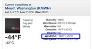
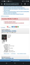
How exactly do you get freezing fog with a 91mph wind?New all time record windchill for the US last hour at Mt Washington NH.
SWVAwxfan
Member
Good question.How exactly do you get freezing fog with a 91mph wind?
Temps going to continue to drop like a rock tonight. Wonderful winter night and possibly coldest since Christmas
Drizzle Snizzle
Member
could be the last freeze of the year for some.Temps going to continue to drop like a rock tonight. Wonderful winter night and possibly coldest since Christmas
18zgfs next weekend


It happens in the high country but not with that wind. Seen it in the smokies when you’re in the clouds and they’re moving fast but still freezing to the trees.How exactly do you get freezing fog with a 91mph wind?
SWVAwxfan
Member
12 Euro been advertising this for 3 runs in a row now. Same time. Little to warm this run

12z Canadian has been cutting to GL last 2 runs, like the gfs was yesterday.
12z Canadian has been cutting to GL last 2 runs, like the gfs was yesterday.
Maybe well south of I-20. North of there even in the mildest winters you’ll see freezes at least until mid to late Marchcould be the last freeze of the year for some.
Drizzle Snizzle
Member
Atlanta's earliest last freeze was on February 5 so i wouldnt rule it out for Atlanta.Maybe well south of I-20. North of there even in the mildest winters you’ll see freezes at least until mid to late March
- Joined
- Jan 5, 2017
- Messages
- 3,810
- Reaction score
- 6,066
We are in danger of freezes/frost until 4/15. Plants go in the ground, here, 4/15.Maybe well south of I-20. North of there even in the mildest winters you’ll see freezes at least until mid to late March
Drizzle Snizzle
Member
That's true, but there's never a guarantee of a freeze in March or April in Atlanta.We are in danger of freezes/frost until 4/15. Plants go in the ground, here, 4/15.
ITP maybe. Burbs almost certainly will.That's true, but there's never a guarantee of a freeze in March or April in Atlanta.
Maybe in the city and the airport due to urban effects, but away from that in suburbs and where the agricultural effects are at from freezes, it’s highly likely.That's true, but there's never a guarantee of a freeze in March or April in Atlanta.
Drizzle Snizzle
Member
highly likely yes, but i'm sure even in the outlying areas there have been a few years where there was no freeze in March or April.Maybe in the city and the airport due to urban effects, but away from that in suburbs and where the agricultural effects are at from freezes, it’s highly likely.
Chilly out there tonight any way you cut it