iGRXY
Member

I guess if anyone cares at least the TPV is further south.
I guess if anyone cares at least the TPV is further south.


Agreed. Gownensville east to Chesnee north of HWY 11 is the snow honey hole of SC. Been In the Upstate my whole life and it’s comical the drop in snowfall 5 miles make. Temp variances are the same.We can do much better than those south of Spartanburg for sure, but it requires the overall pattern or storm to work for most on this board for me to get anything. The perks of living here is when we do get a storm I fight off warm noses longer, it's generally anywhere from 2-5 degrees colder than those south of 85, I benefit from the lift of the 3500ft mountains only about 5-10 miles to my NW, and in tight CAD events I tend to hold a degree or 2 lower than those around the interstate. the winters of 19-20 and 20-21 for example a friend lives a mile N of 85 got a dusting from each of the handful of novelty snow events and I got around 0.5-1". During 32 Degree rains of 20-21 he got exactly that while I was a degree or 2 colder so I got ice on the trees and bushes. It's just little stuff like that, that counts and helps but for me to see snow or ice it takes the same things for anyone else east of the mountains and along and north of 85 to happen for me to score. Living this far north of the interstate and having an extra 300-400 ft in average elevation vs those along the interstate is great though no doubt and really really helps in marginal setups especially.
winter uncancel?View attachment 131906
Yea and it torches later on... it's at least showing transient cold shots I guess.Cold chasing moisture? Take what we can get I guess?
Sent from my iPhone using Tapatalk
And next winter will be same. Hopefully the el-nino warm pool out in the pacific sets up in good location and not parked right off the SW coast.This is probably the worst cycle of weather for January in recent memory. Same song and dance every week. Rain, cloud, cloud, rain, cloud, rain, dense fog
This is a lethal environment for people battling depression. Stay strong, Kings. Spring is coming

It's a cold chasing moisture setup. Rarely works east of the mountains without some extra lift and backbuilding.
That's fair but our source of air is usually not -30c in this situations. I'm not saying it'll happen and be sizeable, but I think the further NE you are in the state, the better shot you have to end as some snow, maybe.It's a cold chasing moisture setup. Rarely works east of the mountains without some extra lift and backbuilding.
Yep, you need a trailing wave that develops along the frontal boundary. It's almost impossible to have one wave move through, precipitation to start as rain, and then change over to a good backside snowfall. If it happens at all, the best you're going to do is rain to a quick burst of snow that melts on contact.It's a cold chasing moisture setup. Rarely works east of the mountains without some extra lift and backbuilding.
95% of the time though that push is out of the WNW vs. Nish. I think thats why the GEFS is seemingly picking up on this.Yep, you need a trailing wave that develops along the frontal boundary. It's almost impossible to have one wave move through, precipitation to start as rain, and then change over to a good backside snowfall. If it happens at all, the best you're going to do is rain to a quick burst of snow that melts on contact.
There have been instances where eastern NC can get something, but the moisture skips the foothills and Triad regions. Maybe east of the Triangle has a shot at a flurry or brief snowshower?That's fair but our source of air is usually not -30c in this situations. I'm not saying it'll happen and be sizeable, but I think the further NE you are in the state, the better shot you have to end as some snow, maybe.
I mean if I was guessing where it could happen, I'd say from @metwannabe to the sounds. Maybe back as west as TDF. Maybe. We're talking about a ten or fifteen minute snow shower IMO. Nothing more than a T.There have been instances where eastern NC can get something, but the moisture skips the foothills and Triad regions. Maybe east of the Triangle has a shot at a flurry or brief snowshower?
I mean, you're right, it's possible. The air up there is very cold. It would be a pretty rare scenario, though, one that I'd still rate as a long shot. But I guess that's better than no shot.95% of the time though that push is out of the WNW vs. Nish. I think thats why the GEFS is seemingly picking up on this.


The mere fact that we're trying to shoehorn in a trace of snow speaks volumes about where we are with this festering turd of a winter.


Spartanburg County is one of the most interesting counties in the state in terms of microclimates IMO. The county is immediately east of extremely tall mountains so CAD really holds well here. The elevation topography of the county is big with hills and elevation of 500 ft in the southern part of the county to 800-900 ft along the interstate and 1000-1500ft north of there. I mean look at this snow footprint picture and notice where it lines up just south of lol.Agreed. Gownensville east to Chesnee north of HWY 11 is the snow honey hole of SC. Been In the Upstate my whole life and it’s comical the drop in snowfall 5 miles make. Temp variances are the same.
Whenever I see I map like that, I’m amazed of how close that cut off is to I-85. It’s like Mother Nature knows exactly where it isSpartanburg County is one of the most interesting counties in the state in terms of microclimates IMO. The county is immediately east of extremely tall mountains so CAD really holds well here. The elevation topography of the county is big with hills and elevation of 500 ft in the southern part of the county to 800-900 ft along the interstate and 1000-1500ft north of there. I mean look at this snow footprint picture and notice where it lines up just south of lol.
 Florence just got nammed
I remember there was a storm a few years ago (I can't think off the top of my head) Where my girlfriend and I were out at a party at a friends and they were calling for snow that night. The party was in Moore and when we left it hard started raining. When we got up to about 3 miles south of 85 it started switching over to snow, by the time I got to 85 it was probably 80% snow, and by the time we made it home (12 miles north of 85) the roads where already covered. That's how serious that cutoff really is, especially in Marginal setups. When I got my tree and bush toppers, if I got on 26 and drove maybe 1-2 miles into NC it would've been full on ZR and they get a QTR inch of ice at least.Whenever I see I map like that, I’m amazed of how close that cut off is to I-85. It’s like Mother Nature knows exactly where it is
That is truly bleak.
View attachment 131921Florence just got nammed

That’s what sucks, by the time we get a better pattern to shape up (IF) we’re going to be battling sun angle, ground tempts, BL issues, etc. Granted some of our best storms have come in late February / early March, but it’s just nice to get a good cold storm in January.I’m so ready for our March slopfest snowstorm
A legit 2-4" area on the NAM lol
Not buying that unless it is some kind of rates overcoming... dealA legit 2-4" area on the NAM lol
It’s the same here on the east side of CLT metro in Union County, NC. In the January 2017 storm, I was forecasted to get 4-7”, but instead got warm nosed and ended up with ,25” of ice and then 1/2” of snow as the storm was ending. Meanwhile 30 miles north at my parents house in Concord, there was a solid 5” of snow/sleet… my youngest son was so disappointed in how little snow we got, I had to take him to his grandparents house that afternoon to go sledding.I remember there was a storm a few years ago (I can't think off the top of my head) Where my girlfriend and I were out at a party at a friends and they were calling for snow that night. The party was in Moore and when we left it hard started raining. When we got up to about 3 miles south of 85 it started switching over to snow, by the time I got to 85 it was probably 80% snow, and by the time we made it home (12 miles north of 85) the roads where already covered. That's how serious that cutoff really is, especially in Marginal setups. When I got my tree and bush toppers, if I got on 26 and drove maybe 1-2 miles into NC it would've been full on ZR and they get a QTR inch of ice at least.
I’m not buying it either… especially from the NAM at that range. However as has been said, with the cold coming in from more of northerly trajectory, there’s not as much downsloping so perhaps the cold air could work in fast enough to get a few flakes down that way, but that looks very extremeNot buying that unless it is some kind of rates overcoming... deal
I was in Davidson at the time and I ended up with 7”. Two places that are always gonna win: Lake Norman and Roxboro.It’s the same here on the east side of CLT metro in Union County, NC. In the January 2017 storm, I was forecasted to get 4-7”, but instead got warm nosed and ended up with ,25” of ice and then 1/2” of snow as the storm was ending. Meanwhile 30 miles north at my parents house in Concord, there was a solid 5” of snow/sleet… my youngest son was so disappointed in how little snow we got, I had to take him to his grandparents house that afternoon to go sledding.
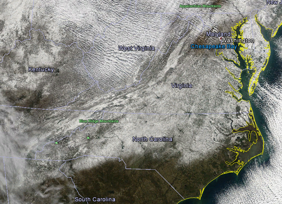
Just to reinforce some of what's been posted here today about the 85 Gradient.I was in Davidson at the time and I ended up with 7”. Two places that are always gonna win: Lake Norman and Roxboro.
One thing is for sure. Over the last 3 or 4 years Dallas has had a lot more wintry weather than Atlanta.Meanwhile Dallaska strikes again. So sick of hearing about winter in Texas. At least we have the snowless I-95 corridor to warm the cockles of our hearts.
Sent from my iPhone using Tapatalk
Now its 27 in Dallas and 65 in Atlanta. That's an improvement !I remember in 2021 it was like 15° in Dallas and 65° in Atlanta. The worst.
Sent from my iPhone using Tapatalk

