I hope you guys know you have got mack slappin his knees rn ?
-
Hello, please take a minute to check out our awesome content, contributed by the wonderful members of our community. We hope you'll add your own thoughts and opinions by making a free account!
You are using an out of date browser. It may not display this or other websites correctly.
You should upgrade or use an alternative browser.
You should upgrade or use an alternative browser.
Pattern Fab-February 2020 The dark age
- Thread starter Ilovesnow28
- Start date
Ilovesnow28
Member

L
Logan Is An Idiot 01
Guest
Thank you so muchOk, so look at the 1002 isobar line and how elongated it is. To me it is ripples of low pressure withing a broader area. So, it didn't move SW, it developed a new center there. But that's if you believe the GFSWe would be better off with a more tightly wrapped up low.
ATLwxfan
Member
Eerily similar GFS runs as what we had a few weeks ago. Honestly not sure what to expect.
Sent from my iPhone using Tapatalk
Sent from my iPhone using Tapatalk
avlsnow
Member

What a mess from our favorite model
Ilovesnow28
Member
 smh
smhThe Euro looked way better this run.
It actually looked even more interesting with energy that strengthens over AZ. Hopefully ensembles should be interesting.


It actually looked even more interesting with energy that strengthens over AZ. Hopefully ensembles should be interesting.
Brent
Member
So close
.png")
Wow euro at the end of the run had a beautiful positive PNA and an outstanding -NAO which are both being supported by its ensemble members ... good lord I love to see the trends .. soon euro will be spitting out fantasy’s

L
Logan Is An Idiot 01
Guest
Wow euro at the end of the run had a beautiful positive PNA and an outstanding -NAO which are both being supported by its ensemble members ... good lord I love to see the trends .. soon euro will be spitting out fantasy’s
Attachments

Webberweather53
Meteorologist
Latest EPS is suite trying to hone in on the US HWY 74 corridor for a chance of light snow Thursday morning.
By far & away the best looking suite yet.

By far & away the best looking suite yet.
Webberweather53
Meteorologist
Off topic, but I am willing to bet that Pivotal is just about to set up a pay/subscription plan. Getting everyone on board using their stuff, then one day: bam, paywall.
The trend on the Gfs is Interesting to say the least..Latest EPS is suite trying to hone in on the US HWY 74 corridor for a chance of light snow Thursday morning.
By far & away the best looking suite yet.
View attachment 32267
Webberweather53
Meteorologist
Off topic, but I am willing to bet that Pivotal is just about to set up a pay/subscription plan. Getting everyone on board using their stuff, then one day: bam, paywall.
To have access to both the UKMET & European w/ sounding data is hard to resist and you simply won't find that anywhere else.
I'm really struggling to find anything beautiful or outstanding about this image. This looks pretty meh and mediocre all the way around. I'm not 100% sure this would even qualify as a +PNA....maybe. But I certainly can't find an outstanding -NAO.Wow euro at the end of the run had a beautiful positive PNA and an outstanding -NAO which are both being supported by its ensemble members ... good lord I love to see the trends .. soon euro will be spitting out fantasy’s

To have access to both the UKMET & European w/ sounding data is hard to resist and you simply won't find that anywhere else.
The only other source of the raw #s/sounding we had was Accuweather Pro back in the day... outside of nice NWS/Pro Forecaster members that would post some for us.
I asked Ryan Maue about adding the raw data, and he thought there wasn't much interest in it..
So Pivotal... yeah.. it's good stuff to have that upper level data. Hopefully they'll have a lot for like 9.99 a month or something like that.
What did the 6z Euro showed it only goes out to 90hr.I'm really struggling to find anything beautiful or outstanding about this image. This looks pretty meh and mediocre all the way around. I'm not 100% sure this would even qualify as a +PNA....maybe. But I certainly can't find an outstanding -NAO.
View attachment 32268
Webberweather53
Meteorologist
I'm really struggling to find anything beautiful or outstanding about this image. This looks pretty meh and mediocre all the way around. I'm not 100% sure this would even qualify as a +PNA....maybe. But I certainly can't find an outstanding -NAO.
View attachment 32268
The Euro's PNA forecast is dead neutral at day 10 although it's had a non-negligible -PNA bias especially in the extended.

What did the 6z Euro showed it only goes out to 90hr.
The off hour euro models 06/18) don't go out very far versus the 12/00z.
I agree 100%. I don't see any support for anything going forward but more of the same. Average temps and active STJ. Getting anything at all will be a miracle in this pattern. Just no real cold air.I'm really struggling to find anything beautiful or outstanding about this image. This looks pretty meh and mediocre all the way around. I'm not 100% sure this would even qualify as a +PNA....maybe. But I certainly can't find an outstanding -NAO.
View attachment 32268
ForsythSnow
Moderator
I hope they keep some stuff free at least. It would suck big time to lose it all with a paywall.Off topic, but I am willing to bet that Pivotal is just about to set up a pay/subscription plan. Getting everyone on board using their stuff, then one day: bam, paywall.
ATLwxfan
Member
I agree 100%. I don't see any support for anything going forward but more of the same. Average temps and active STJ. Getting anything at all will be a miracle in this pattern. Just no real cold air.
Yeah no amount of wishcasting can beat that pac jet. Multiple opportunities for the mountains at least and maybe NC and certainly TN. For the rest of us, it’s getting close to calling it a season barring anything extraordinary.
Sent from my iPhone using Tapatalk
Yeah no amount of wishcasting can beat that pac jet. Multiple opportunities for the mountains at least and maybe NC and certainly TN. For the rest of us, it’s getting close to calling it a season barring anything extraordinary.
Sent from my iPhone using Tapatalk
It is far too early to make that call. It is difficult to have a clue as to how the pattern will be past about 2 weeks.
Nomanslandva
Member
850s ok all the way to I85 but BL too warm. 1010 low is not going to do it. AT least ICON and GFS looked a little more organised this run. 
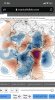
Look at the 500 mb height anomaly you’ll find itI'm really struggling to find anything beautiful or outstanding about this image. This looks pretty meh and mediocre all the way around. I'm not 100% sure this would even qualify as a +PNA....maybe. But I certainly can't find an outstanding -NAO.
View attachment 32268

I couldn't find it.Look at the 500 mb height anomaly you’ll find it
I posted aboveI couldn't find it.
Storm5
Member
A few inches of modeled snow with temps crashing into the mid twenties inside day ten
What could possibly go wrong


Sent from my iPhone using Tapatalk
What could possibly go wrong


Sent from my iPhone using Tapatalk
whatalife
Moderator
A few inches of modeled snow with temps crashing into the mid twenties inside day ten
What could possibly go wrong
Sent from my iPhone using Tapatalk
I personally like this fail better.

Sent from my iPhone using Tapatalk
packfan98
Moderator

Wow congrats coastal areas this run! Was close to something huge for all of the south east but dang I love to see that look at around 240 .. lots of cold air in play per the Gfs .. so take with 800 grains of salt
GeorgiaGirl
Member
Sure hope so.
February remains looking interesting to me, and it does earlier rather than later. Get the feeling that we can't go for our 5th year in a row of no cold in this month. May get something in the first couple weeks, then flip to spring.
So close, yet so far away..this has no doubt been a popular timeframe thoughI personally like this fail better.
Sent from my iPhone using Tapatalk
This is how it’s done, folks..not a ton of moving parts here which may be why this keeps showing up

whatalife
Moderator
So close, yet so far away..this has no doubt been a popular timeframe though
Not sure how much support if any this timeframe has but the GFS op has been consistent w/at least a storm signal here.
Sent from my iPhone using Tapatalk
Look even behind this wave .. a parade of storms might try to pinwheel aroundThis is how it’s done, folks..not a ton of moving parts here which may be why this keeps showing up
View attachment 32285