Blue_Ridge_Escarpment
Member
Model recap for this event:
12k NAM - A+
GFS - C
EURO - F
12k NAM - A+
GFS - C
EURO - F
That time frame serves watching. The GFS is the most aboard next to the ICON. The Euro looks like it's similar but much drier. There's too much going on with the timing of the energy waves but we will know if it can do something when we get closer. It might not be much but if something comes out of it, it's better than nothing.18z GFS looks like its wanting to bring something back in next weekend.
Sent from my SM-G955U using Tapatalk
Giddy, cusp insanity ... a perfectly logical explanation to the illogical ...How in the world did this thread become an observation thread for an event that is happening in January?
Please do better guys!


How in the world did this thread become an observation thread for an event that is happening in January?
Please do better guys!
Edit: For the next event, please make a thread for it and observations instead of the pattern thread for another month.
Jon,I’m so confused to see nearly 600 new posts in the February thread. It’s January everyone!!!
Sent from my iPhone using Tapatalk
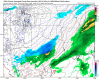
What exactly constitutes a trace? Snow falling? Or a mix of heavy rain and even the slightest IP for one second?Here's a preliminary map of today's "surprise" snow event in NC. Southern mountains were the big winners w/ 3-4" of snow reported near Hendersonville. As always, I want to say thanks to everyone for sending their pics and backyard observations, that definitely helped in making this map.
View attachment 32784


NAM needs more credit on winter events.Model recap for this event:
12k NAM - A+
GFS - C
EURO - F
Add the RAP above the NAM ?Model recap for this event:
12k NAM - A+
GFS - C
EURO - F
What exactly constitutes a trace? Snow falling? Or a mix of heavy rain and even the slightest IP for one second?
I was in southern Granville from 9-6 and saw no mixing. Even tried to verify on CC radar (which I saw definite mixing) and every time I thought there would be some I went outside, nothing. Just rain. Not sure a trace verified there but I could have missed it. I saw Allans reports of snow near his house so the map would make sense. Just wondering what it looked like lol
Sent from my iPhone using Tapatalk
A trace of snow or sleet is snow &/or sleet literally falling from the sky but not sticking to the ground. I saw a few mPING reports of sleet mixed w/ rain in Granville & Vance counties and trace amounts of wintry precipitation would be spatially and temporally consistent with other (numerous) reports in Franklin, Durham, Orange, Alamance, & Wake counties just to the south where snow & sleet definitely mixed in and the environment was less supportive of snow & sleet.
You are correct sir. Or at least equal!Add the RAP above the NAM ?
A trace of snow or sleet is snow &/or sleet literally falling from the sky but not sticking to the ground. I saw a few mPING reports of sleet mixed w/ rain in Granville & Vance counties and trace amounts of wintry precipitation would be spatially and temporally consistent with other (numerous) reports in Franklin, Durham, Orange, Alamance, & Wake counties just to the south where snow & sleet definitely mixed in and the environment was less supportive of snow & sleet.


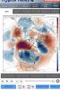
You gotta be kidding. Yes, it snowed but NAM was trash for days as seen below. You need to go back and look at euro.Model recap for this event:
12k NAM - A+
GFS - C
EURO - F

Quiet a few runs in a row with snow near/over you! I think you gonna pull this off, cause JB said so this morning!!! ? ? Hope you get a few inches!
0.5” snow around Elkin Surry County becoming more widespread in Roaring River in eastern Wilkes Co. The most I’ve heard is 1-2” in southern Wilkes on the Brushy mtns. Northern Irdell to western Iredell around 0.25” snow fell total including all snow bands melting throughout the day etc. The sleet line, provided a Trace across Wilkes but increased rapidly up to a tenth of inch near Olin, Iredell where it fell heavy for 1-2 hours. Below is one view of the brushy mtns but unsure what elevation in Wilkes. The next image was in Statesville, Iredell near the hospital of road conditions.


Haha haha. This is banter-ish but...
I'm getting a little angry here, that even Durham is getting in on the action.
After your massive bust today, I figured you would gracefully bow out of the forecasting business.Looking ahead, looks like we may pay for early Feb warmth when temps scorch 10 to 20 degrees for roughly 1-2 days next week. EURO brings glancing shots of cold combine with an active STJ. And nearing the winter-spring transition season can mean bad weather in the Carolinas. IMO, I could see a CAD event by mid Feb or sooner. Plus more winter events in late Feb. I DONT think March will be favorable for winter weather like in previous years where western NC had major events.
EURO sucked. I’m giving the nod to the Ukie/RAP comboYou gotta be kidding. Yes, it snowed but NAM was trash for days as seen below. You need to go back and look at euro. View attachment 32792
Why don’t u think March will be as wintry as last years?Looking ahead, looks like we may pay for early Feb warmth when temps scorch 10 to 20 degrees for roughly 1-2 days next week. EURO brings glancing shots of cold combine with an active STJ. And nearing the winter-spring transition season can mean bad weather in the Carolinas. IMO, I could see a CAD event by mid Feb or sooner. Plus more winter events in late Feb. I DONT think March will be favorable for winter weather like in previous years where western NC had major events.
The bird doesn't think, he knowsWhy don’t u think March will be as wintry as last years?
Congrats Jessy! Fun dayAfter playing in the 3 inches of snow near tuxedo/Hendersonville. I got a room in Maggie Valley I want pancakes tomorrow yum!
Sent from my iPhone using Tapatalk
The euro had ZERO accumulating snow outside of the mtns until the 12Z run today. It was horrendous.You gotta be kidding. Yes, it snowed but NAM was trash for days as seen below. You need to go back and look at euro. View attachment 32792
3k saying half a foot is possible above 5k tomorrow afternoon into Sunday morningThe euro had ZERO accumulating snow outside of the mtns until the 12Z run today. It was horrendous.


.png")