Ha! I don’t know how I ended up with that tweet? I didn’t realize it was from 12/30 I certainly didn’t do it intentionally. I apologize, but it still appears useful today. LolGot it. I didn't realize that. All of the other graphics were from today.
-
Hello, please take a minute to check out our awesome content, contributed by the wonderful members of our community. We hope you'll add your own thoughts and opinions by making a free account!
You are using an out of date browser. It may not display this or other websites correctly.
You should upgrade or use an alternative browser.
You should upgrade or use an alternative browser.
Pattern Fab-February 2020 The dark age
- Thread starter Ilovesnow28
- Start date
Unless we cruise through with no frosts any flowering fruit tree is in big troubleApples in trouble again?
ajr
Member
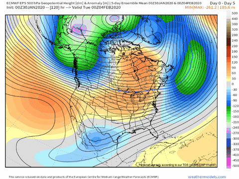
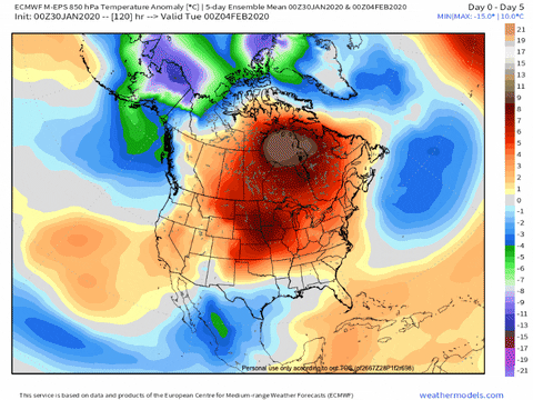
You almost couldn't draw a more terrible forecast:

baroowoofr
Member
Bleaklies. At least for once they give no hope, and maybe that is a sign things are about to turn:
Webberweather53
Meteorologist
Don’t worry, higher amplitude pulses like the one that might be coming move even slower, so more time in warm phases is incoming. Big oofYou almost couldn't draw a more terrible forecast:
View attachment 32637
NCHighCountryWX
Member
- Joined
- Dec 28, 2016
- Messages
- 700
- Reaction score
- 1,921
That MJO forecast map is a month old and misleading. The weather is bad enough that you shouldn't have to use misleading data to make your point. GRRR!
BAMWX had retweeted their earlier early January tweet to I think just emphasize their modified forecast had verified.
There it comes for mid MarchBleaklies. At least for once they give no hope, and maybe that is a sign things are about to turn:
You’re probably right. Cold early spring has become just as certain as mild winterBeing a farmer I will say disaster, we will have a frost in April like always but the bugs will get a head start.
looks like plenty below freezing outside of the mountains to me?I vote for long growing season.
Just scroll through the 12z gfs. Almost no temps below 32 for anyone outside mountains.
this is the coldest morning for those outside mountains. View attachment 32635
Jessy89
Member
So should we expect winters for now on the be non existent in the southeast? Is this gonna be the new normal? It’s hard to believe this maybe the 2nd time in recorded history that GSP doesn’t receive any snowfall. I absolutely love snow so it breaks my heart not to get any. I absolutely hate temperatures over 70 degrees so yeah I’m miserable most the year.
Fountainguy97
Member
looks like plenty below freezing outside of the mountains to me?
I said “almost”. That’s the only time in the whole 16 day run there is substantial area below freezing besides mountains. Next coldest nights are tonight and tmrw.
NBAcentel
Member
I’m honestly gasping on straws, but the 3km supports pockets of wet snow outside the mountains, soundings so close as far south as CLT, (very close to isothermal soundings, good lift in the DGZ, heavy precipitation) if you get a microscope you can see pockets of snow in the foothills/NW piedmont, gonna b tons of bright banding on radar tommorow, maybe if someone outside the mountains gets a heavy band of precip, wet snow could mix in ? 


NBAcentel
Member
12km was even better and more closer

Fountainguy97
Member
So should we expect winters for now on the be non existent in the southeast? Is this gonna be the new normal? It’s hard to believe this maybe the 2nd time in recorded history that GSP doesn’t receive any snowfall. I absolutely love snow so it breaks my heart not to get any. I absolutely hate temperatures over 70 degrees so yeah I’m miserable most the year.
This isn’t a “New norm”. It will indeed be snowy again one day. We just have had two rough years back to back. MJO has been pretty rebellious the last two winters with little time spent on the left side (colder) of the graph.
Blocking has lacked substantially when we needed it both years as well.
just 2 bad years
I don’t think anyone knows. Certainly in my 50 years living in NC they “don’t make winters like they used to”. Obviously teleconnections have not helped us, but it seems even when they are not bad we find a way to be warm.This isn’t a “New norm”. It will indeed be snowy again one day. We just have had two rough years back to back. MJO has been pretty rebellious the last two winters with little time spent on the left side (colder) of the graph.
Blocking has lacked substantially when we needed it both years as well.
just 2 bad years
I do agree this is not the new normal. However I do disagree that its only been a 2 year problem. The lack of blocking on the Atlantic side has been a problem for a decade almost. I still has managed to snow yes. But anyone looking to break this cycle of above average warmth in winter, especially December and February need to look at the NAO and lets try to see what's causing its run of positive winters.This isn’t a “New norm”. It will indeed be snowy again one day. We just have had two rough years back to back. MJO has been pretty rebellious the last two winters with little time spent on the left side (colder) of the graph.
Blocking has lacked substantially when we needed it both years as well.
just 2 bad years
Storm5
Member
Where is Brent multiple gfs and euro runs have him getting wintry next week oh and the CMC
Sent from my iPhone using Tapatalk
Sent from my iPhone using Tapatalk
Stormlover
Member
I know winters have sucked lately..but this is a good story that puts it in perspective Link: Warming and the snows of yesteryearI don’t think anyone knows. Certainly in my 50 years living in NC they “don’t make winters like they used to”. Obviously teleconnections have not helped us, but it seems even when they are not bad we find a way to be warm.
This isn’t a “New norm”. It will indeed be snowy again one day. We just have had two rough years back to back. MJO has been pretty rebellious the last two winters with little time spent on the left side (colder) of the graph.
Blocking has lacked substantially when we needed it both years as well.
just 2 bad years
Nothings changing until the SST’s in the maritime change. It’s boiling water which just fuels 4-5 over and over.

BHS1975
Member
Nothings changing until the SST’s in the maritime change. It’s boiling water which just fuels 4-5 over and over.
View attachment 32646
They will only get warmer.
Sent from my iPhone using Tapatalk
Meanwhile waters southeast of Madagascar in the Indian Ocean are well below normal..we just need those to mix in, somehowNothings changing until the SST’s in the maritime change. It’s boiling water which just fuels 4-5 over and over.
View attachment 32646
BHS1975
Member
Meanwhile waters southeast of Madagascar in the Indian Ocean are well below normal..we just need those to mix in, somehow
Meltwater from Antarctica?
Sent from my iPhone using Tapatalk
The 2010s were above average in snowfall for most of NC, though (compared to the 1981-2010 average). Perception isn't always reality.I don’t think anyone knows. Certainly in my 50 years living in NC they “don’t make winters like they used to”. Obviously teleconnections have not helped us, but it seems even when they are not bad we find a way to be warm.
So you're thinking the MJO has fueled the EPO the last few winters and destroyed the chances of a -NAO? As we know a -EPO tends to destroy a -NAO. Has the MJO constantly been in warm phases in winter since 2011? Our NAO problem has been persistent since then and the type of winter most on here hope for depends on it.Nothings changing until the SST’s in the maritime change. It’s boiling water which just fuels 4-5 over and over.
View attachment 32646
Batman
Member
Believe the sky is falling and the earth is boiling if you wish. I will not get into an argument about that. I will say this. Average annual snowfall for MBY is about 2". I have lived in Fayette County GA for 28 years. My snowfall over that time has averaged out to just above 2" per year. Within that time, we have had 4 and 5 year snow droughts. It is disappointing, but it happens when you are in the deep south.
To keep somewhat on topic, I will agree that the remainder of the winter is looking rather bleak. I will also say that 1993 was looking rather bleak until March 13. I have learned many times to never say never. I have also learned that you speak in absolutes at your own risk.
To keep somewhat on topic, I will agree that the remainder of the winter is looking rather bleak. I will also say that 1993 was looking rather bleak until March 13. I have learned many times to never say never. I have also learned that you speak in absolutes at your own risk.
Whatever it takes to get me my snow lol. How come white on that map represents both normal and slightly below normal? I find that misleading. The maritime is roasting, regardless. No argument thereMeltwater from Antarctica?
Sent from my iPhone using Tapatalk
So you're thinking the MJO has fueled the EPO the last few winters and destroyed the chances of a -NAO? As we know a -EPO tends to destroy a -NAO. Has the MJO constantly been in warm phases in winter since 2011? Our NAO problem has been persistent since then and the type of winter most on here hope for depends on it.
Absolutely, the MJO has been in 4 and 5 a significantly higher % of winter days on average the last 10 years vs, say, the 1980s. I've written about it in response to someone posting a recent study about this. I counted the days to verify the study's results and it verified well. So, global warming has been hitting the SE in two ways: overall warmer background temps and more pronounced waming in the Maritime Continent vs surrounding areas has increased the % of days in MJO phases 4 and 5. So a double whammy!
See the Global Warming thread for more on this.
MichaelJ
Member
Folks, until we can get a -EPO and have the ridge go up in Alaska there will be little change in the warm forecasts. Unfortunately the EURO has indicated this will not happen anytime soon. As I said in a post a week or 2 ago, we will get the EPO to flip and the NAO as well in late March or early April when it will do most outside the mountains no good for wintry precipitation. Pray we don't torch excessively until then or else a lot of flowering plants and fruits will get destroyed in late March-April. 
Brent
Member
Where is Brent multiple gfs and euro runs have him getting wintry next week oh and the CMC
Sent from my iPhone using Tapatalk
I'm around we've been burned so many times I'll believe it when I see it lol
The Euro missed to the NW

pcbjr
Member
I love the Alachua County line there, Larry ...Impressive cold!
View attachment 32647
For the few following. The 18z GEFS was a large uptick for the Sylva North Carolina location. 

avlsnow
Member
What about Asheville?For the few following. The 18z GEFS was a large uptick for the Sylva North Carolina location. View attachment 32648View attachment 32649
NBAcentel
Member
Hrrr is close, just warm at the sfc 
I know these maps are skipping ahead to early March and they're from a terrible model, the CFS, but imagine if this were to occur. We'd be looking at near mid Jan normals in early March: upper 30s RDU/GSP, low 40s ATL/BMX, near 50 SAV/CHS, low to mid 50s GNV, etc. This is the coldest 5 day period on the entire run and it isn't til early March. That kind of thing can easily occur:


What about Asheville?

tennessee storm
Member
thank god spring is coming early then... cause the cold weather long range has never verified this winterI know these maps are skipping ahead to early March and they're from a terrible model, the CFS, but imagine if this were to occur. We'd be looking at near mid Jan normals in early March: upper 30s RDU/GSP, low 40s ATL/BMX, near 50 SAV/CHS, low to mid 50s GNV, etc. This is the coldest 5 day period on the entire run and it isn't til early March. That kind of thing can easily occur:
View attachment 32652
View attachment 32653
I haven’t been following as the NAM is awful in many respects. With that being said, Beech MTN will see some action worth following this weekend. NAM has always been terrible with snowfall along the blue ridge..esp Boone to Wilkesboro. Maybe not as bad as the CMC ice maps but I see it has been spitting out goofy maps.
Last edited:
Also wanna shoutout the RGEM for being too cold. The bias is so bad it snows in hickory, Wilkes and Statesville. That’s not gonna happen as temps verify 5-10 degrees warmer on reliable guidance.
I don’t know where to find all the numbers, but I believe I read not long ago that total inches are higher, while number of events and days with snow on the ground are less, at least at RDU. So fewer events, but heavier amounts when it does snow.The 2010s were above average in snowfall for most of NC, though (compared to the 1981-2010 average). Perception isn't always reality.