It’s inside 60hr..? NAM’d or legs?
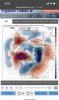
I mean is this that bad of a look? Sure everything’s not in a great place.. would love some -NAO but that’s not there but that ridging off the west coast and into Alaska doesn’t look so bad right?
I mean is this that bad of a look? Sure everything’s not in a great place.. would love some -NAO but that’s not there but that ridging off the west coast and into Alaska doesn’t look so bad right?
Couldn’t this ridge adjust positions with time? Also how far into Alaska must it go in order for us to receive more cold air?Get rid of that NE Pacific ridge like what just happened and we can get cold in the SE just like what happened. That is a tele to a strong SER. Do you want that? I'd rather have a ridge in W NA/+PNA.
My worse winter gave my 1" of snow. So I've never been blanked while living in this area. So far I haven't seen a sleet pellet.I stand by my call that RDU zeros out this winter.
Couldn’t this ridge adjust positions with time? Also how far into Alaska must it go in order for us to receive more cold air?
My worse winter gave my 1" of snow. So I've never been blanked while living in this area. So far I haven't seen a sleet pellet.
I hate to start mentioning March, but that may be our best chance to see anything. This pattern should break down with the arrival of the spring pattern (shorter wave lengths). Our odds will still be (normally) low, but at least we'll have a chance.
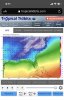
Historic ice and sleet storm on 18z GFS
Sent from my iPhone using Tapatalk
Kinda reminds of the famous 1994 February ice storm that happen in the southeast.Southern MS and AL totally obliterated by ice.
Sent from my iPhone using Tapatalk


I think I seen this movie before. Let's just see if we can get it to stay on the model for a few runs. I like the look of that cold air more than the storm.Southern MS and AL totally obliterated by ice.
Sent from my iPhone using Tapatalk

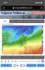
Holy hell it goes on for days.

Sent from my iPhone using Tapatalk
Holy hell it goes on for days.
Sent from my iPhone using Tapatalk
Idk. That Toccoa snow/ice hole is pretty believableMight be banner but it belongs here NO CHANCE
Sent from my iPhone using Tapatalk
And the CAE shutoutIdk. That Toccoa snow/ice hole is pretty believable
the CAE one as wellIdk. That Toccoa snow/ice hole is pretty believable

Hahah, the warm nose is like giving us the middle finger...Idk. That Toccoa snow/ice hole is pretty believable
That's way better than the pattern we're in now. It's nice to see the -EPO all the way to the pole. That could evolve nicely down the line. Of course it has to verify and the GFS has been horrible with the EPO all year.Talk about Siberian express.

Sent from my iPhone using Tapatalk
Might be banner but it belongs here NO CHANCE
Sent from my iPhone using Tapatalk
 Oh lord .. what would this even look like
Yes, but only plausible if the PNA goes negativeWe buying the -EPO? All globals/ens agree.
View attachment 32555View attachment 32556View attachment 32557View attachment 32558
Seems they are in agreement of some sort of -EPO around the 7-15 timeframe .... we will see ... has there ever been a time this winter when all these models had -EPO showing up for the same time period and then failed?We buying the -EPO? All globals/ens agree.
View attachment 32555View attachment 32556View attachment 32557View attachment 32558
Yes, but only plausible if the PNA goes negative


Hell why not? What we're in now ain't gonna cut it. What do we have to lose?We buying the -EPO? All globals/ens agree.
View attachment 32555View attachment 32556View attachment 32557View attachment 32558
The key is getting the ridge to be centered over or north of Alaska, the -PNA will break down if this occurs and the big Hudson Bay vortex would slide further south. Very subtle changes to the character of a -EPO turn one of the worst patterns for snow to an amazing oneHell why not? What we're in now ain't gonna cut it. What do we have to lose?
View attachment 32561Oh lord .. what would this even look like
The key is getting the ridge to be centered over or north of Alaska, the -PNA will break down if this occurs and the big Hudson Bay vortex would slide further south. Very subtle changes to the character of a -EPO turn one of the worst patterns for snow to an amazing one