And if that is the case it might be a late spring (temp wise)Yeah, that SE ridge keeps most of the cold west of the Appalachians out to day 16. One thing is apparent, we wont go into this spring in a drought:
View attachment 32503
-
Hello, please take a minute to check out our awesome content, contributed by the wonderful members of our community. We hope you'll add your own thoughts and opinions by making a free account!
You are using an out of date browser. It may not display this or other websites correctly.
You should upgrade or use an alternative browser.
You should upgrade or use an alternative browser.
Pattern Fab-February 2020 The dark age
- Thread starter Ilovesnow28
- Start date
tennessee storm
Member
Not sure if it’s been mentioned r not . But system early next week holds some severe wx. Potential for parts south... depending if a healthy warm sector can develop
It seems that warm winters tend to bring cold springs. At least from my memory. Also if this pattern (with southern storm track) was to persist into spring, it would provide a cold outcome (average wise); which I think you're alluding to.And if that is the case it might be a late spring (temp wise)
Storm5
Member
I’m just saying he always finds a way to connect any pattern to the big dogs of the past, seemingly forgetting that there’s a reason why those type of storms happen infrequently. He just loses all credibility when he consistent does this. But that’s my opinion.
I agree with you . He always finds a way to show some ensemble run to validate his cold screaming . What’s funny is what he showed wasnt the latest eps run . I wonder why ......
Sent from my iPhone using Tapatalk
D
Deleted member 1449
Guest
apparently you didn't read his words, he said the same thing rarely happens, but it was the best look we've had...that's all
His own words:Similar more often than not tho, does not produce the same, but pattern certainly looks more wintery than recent weeks.
This will be my last response to this, as I don't wish to derail this thread any further. I read all of his words. But he still manged to insert a reference to an historic storm, and then he gave the qualifying statement. It seems to me to be a nice way to have it both ways. I freely admit I could be wrong.
Yeah if we had any assistance in the north Atlantic we might be able to block that up enough to be good for us but right now it's a texas,oklahoma, tn, ms, ark, ky lookI’m still a fan of the 6th-8th for some sort of possible overrunning event . Especially for western areas as the SE ridge tries to push back against the front
Sent from my iPhone using Tapatalk
Stormlover
Member
He did post the last one, which was 0Z. he actually posted 12 Z yesterday and 0Z today and it came out early this morning. I only posted one of the two he showed.I agree with you . He always finds a way to show some ensemble run to validate his cold screaming . What’s funny is what he showed wasnt the latest eps run . I wonder why ......
Sent from my iPhone using Tapatalk
Storm5
Member
Agreed that’s why I said western areas . Truth be told come verification time it will be good for TX ,OK , MO
Sent from my iPhone using Tapatalk
Sent from my iPhone using Tapatalk
WxBlue
Meteorologist
The CMC was interesting especially with that hp up north
Sadly, we want the high sitting over New England to funnel the cold into CAD region. 1022 mb also isn't that strong enough for wintertime Arctic high either.
No caa on the back of the initial system means no chanceI know. I didn't mean that as a slight against you. Just dry humor. Sorry.
40 is workable at this range.
True but it's 8-10 days out and has time for the hp's and lp's to move into more favorable/unfavorable places and time for things trend stronger/weaker.Sadly, we want the high sitting over New England to funnel the cold into CAD region. 1022 mb also isn't that strong enough for wintertime Arctic high either.
WxBlue
Meteorologist
True but it's 8-10 days out and has time for the hp's and lp's to move into more favorable/unfavorable places and time for things trend stronger/weaker.
Forgive me for not feeling more optimistic haha.
"GLAAM Trends Contributing To Forecast Pattern
Negative trends in the GLAAM contribute to the forecast pattern over the next 15 days. GLAAM refers to Globally Averaged Angular Momentum and is a measure of winds relative to Earth’s rotation. It has been in its positive phases since mid-January and is forecast to return to neutral early next week. After that, an increasingly negative signal evolves, and trends from the Euro EN are additionally more negative in the longer range since its projections from yesterday. The GLAAM can be categorized by the Global Wind Oscillation (GWO), which contains eight phases depending on positive or negative state and trend. The next 15 days sees the measure progressing through GWO phases 8, 1 and 2, and historical composites for those phases at the 500mb level are shown below. The evolution is associated with a buildup in ridging over the eastern Pacific this time of year; although, the ridge is most often focused south of Alaska and thus lacks a clear connection to more significant colder source regions. Still, a trough is often seen over the Mid-Continent, which is reflected in the models." from Maxar
Negative trends in the GLAAM contribute to the forecast pattern over the next 15 days. GLAAM refers to Globally Averaged Angular Momentum and is a measure of winds relative to Earth’s rotation. It has been in its positive phases since mid-January and is forecast to return to neutral early next week. After that, an increasingly negative signal evolves, and trends from the Euro EN are additionally more negative in the longer range since its projections from yesterday. The GLAAM can be categorized by the Global Wind Oscillation (GWO), which contains eight phases depending on positive or negative state and trend. The next 15 days sees the measure progressing through GWO phases 8, 1 and 2, and historical composites for those phases at the 500mb level are shown below. The evolution is associated with a buildup in ridging over the eastern Pacific this time of year; although, the ridge is most often focused south of Alaska and thus lacks a clear connection to more significant colder source regions. Still, a trough is often seen over the Mid-Continent, which is reflected in the models." from Maxar
NBAcentel
Member
"GLAAM Trends Contributing To Forecast Pattern
Negative trends in the GLAAM contribute to the forecast pattern over the next 15 days. GLAAM refers to Globally Averaged Angular Momentum and is a measure of winds relative to Earth’s rotation. It has been in its positive phases since mid-January and is forecast to return to neutral early next week. After that, an increasingly negative signal evolves, and trends from the Euro EN are additionally more negative in the longer range since its projections from yesterday. The GLAAM can be categorized by the Global Wind Oscillation (GWO), which contains eight phases depending on positive or negative state and trend. The next 15 days sees the measure progressing through GWO phases 8, 1 and 2, and historical composites for those phases at the 500mb level are shown below. The evolution is associated with a buildup in ridging over the eastern Pacific this time of year; although, the ridge is most often focused south of Alaska and thus lacks a clear connection to more significant colder source regions. Still, a trough is often seen over the Mid-Continent, which is reflected in the models." from Maxar
So basically, the GOA ridge we all love
smast16
Member
So basically, the GOA ridge we all love
And the WAR we are seeing.
So basically, the GOA ridge we all love
Indeed! And here's part 2 from the same release:
"Mid-Range Pattern Reflecting +TNH and +AO
In the story above, the trends in the GLAAM were discussed as contributing to the forecast pattern, particularly with the placement of a ridge over the eastern Pacific and a trough over the Mid-Continent. Those features are associated with a pattern of +TNH characteristics. Another contributor to the pattern is in the high latitudes, where strengthened winds reflect a +AO state. These winds help to lock Arctic air in the polar region and is a warm signal across the middle latitudes this time of year. In the 6-10 Day period, the pattern continues to direct Pacific flow into the U.S., thanks to continued troughing near Alaska (i.e. +EPO). A pattern including the +TNH, +AO and +EPO resembles the forecast in the 6-10 day period, as historically the combination supports variability from the West to Central (insignificant correlation to temperatures) and warmer air in the Eastern Half. The +EPO signal weakens in the 11-15 Day (still +TNH and +AO), which could increase colder opportunities in the North as the South stays warm." from Maxar
Euro looks different altogether at HR 216 compared to 00z.
NBAcentel
Member
This winter in a broken nutshell, look at that little bit of ridging that was on AK fade away as those lower heights take control and we get this look, that +AO gots to go 
Well meh still too weak with the cold air pushWell today’s Euro has a better 5H look at day 8 FWIW. Could get interesting
packfan98
Moderator
This looks familiar...

Well meh still too weak with the cold air push
And on that note, a decent track for some of the NW portions of the SE but not a lot of cold air to work with/no real surface high:

Some mountain snow though per this Doc:

NBAcentel
Member
The H5 pattern on the 300+ hour gfs was insane, insane Aleutian ridge, Insane cold vortex in Canada with constant energy swinging around it and a hell of a SE ridge right on the edge, wata
slower with the storm, at least we can say it improved.This looks familiar...

Careful. I caught a lot of flack yesterday for talking about how warm it’s going to be under that ridge..
ATLwxfan
Member
My fears on the Feb 7 timeframe have already materialized..and for that reason, I’m out #WAR
View attachment 32508
See you after the 18z

Sent from my iPhone using Tapatalk
Careful. I caught a lot of flack yesterday for talking about how warm it’s going to be under that ridge..
Unfortunately, warmth is all we have. The good news is every EPS run has been trending warmer for next week.
I went a few days without looking that much but then the past couple of days I've been trying to find some ray of hope....come to the conclusion there's no hope.


That's workable with a more OTS surface low track, I think. Not that that's going to happen, but it's possible.And on that note, a decent track for some of the NW portions of the SE but not a lot of cold air to work with/no real surface high:
View attachment 32517
Some mountain snow though per this Doc:
View attachment 32518


Jessy89
Member
I’ve accepted it’s not going to snow outside the mountains or Tennessee thus winter. But part of me still wants to hope. However this winter has sucked big time.
Sent from my iPhone using Tapatalk
Sent from my iPhone using Tapatalk
ATLwxfan
Member
So we already know what things are going to be like mid and late month? Yes we have not had a good winter but we’ve also had lousy modeling and teleconnection forecasting. I can’t make heads or tails of it. Not sure how anyone can. I’ve waffled on this but I think the real answer is we just don’t know aside from analogs. So...what do the analogs show?
Sent from my iPhone using Tapatalk
Sent from my iPhone using Tapatalk
Isn't the SER/NE Pacific ridge couplet just lovely? Isn't the -AAM absolutely wonderful?


Anyone want to take a road trip to CO?

Well, @Brent, @SoutheastRidge, @Golf7575 should like since they're not in the SE.
Yes, the coldest air in the world anomalywise is in the N Rockies. But cold air in the N Rockies does us no good in this case when it is blocked.

Anyone want to take a road trip to CO?
Well, @Brent, @SoutheastRidge, @Golf7575 should like since they're not in the SE.
Yes, the coldest air in the world anomalywise is in the N Rockies. But cold air in the N Rockies does us no good in this case when it is blocked.
Last edited:
That looks pretty bad. Hey, can you drop a suggestion in the suggestion box for Maxckar to upgrade their graphics from DOS? Thanks man!Isn't the SER/NE Pacific ridge couplet just lovely? Isn't the -AAM absolutely wonderful?
View attachment 32531
View attachment 32532
View attachment 32533
Anyone want to take a road trip to CO?
View attachment 32535
Well, @Brent, @SoutheastRidge, @Golf7575 should like since they're not in the SE.
Yes, the coldest air in the world anomalywise is in the N Rockies. But cold air in the N Rockies does us no good in this case when it is blocked.
That looks pretty bad. Hey, can you drop a suggestion in the suggestion box for Maxckar to upgrade their graphics from DOS? Thanks man!
 I'll do so. Have you been using your VCR much lately?
Here's another interesting map, a strat map: look at that Siberian warming! Implications?

Attachments

Webberweather53
Meteorologist
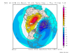
Here's another interesting map, a strat map: look at that Siberian warming! Implications?
View attachment 32537
Weakens the vortex just in time for the middle of spring? Yawn
Webberweather53
Meteorologist
This don't look La Nina like to me. To me, these AAM drops are being driven by IO SST's and seems more symptomatic than a driver.
View attachment 32539
It's definitely not a NINA, the -AAM burst is related to subseasonal variability, but the subtropical jet still hasn't collapsed (as some had initially forecast to occur).
Here's a much earlier strat anomaly map: a decent Arctic warming (stronger than that Siberian warming I just posted) though not nearly as strong as the very strong Arctic SSW of last winter meaning nothing to write home about imo/nothing out of the ordinary:

NBAcentel
Member
These soundings from the NAM around LKN in NC are to close, BL issues but that’s heavy precipitation and excellent lift in the DGZ, close call with a burst of wet snow/rain at the surface with this type of look, probably gonna be lots of brightbanding with this coastal 