• Hello, please take a minute to check out our awesome content, contributed by the wonderful members of our community. We hope you'll add your own thoughts and opinions by making a free account!

Pattern December to Remember

Even so, the 12Z EPS maintains the colder 12/19-22 in much of the country including the SE with its wedge. It is still warm late, but it could be too slow to break down the SER and even if not, MJO climo and many CFS runs have been suggesting that the E US, especially MW to NE will get much colder a few days later.
To me it seems like the Aluetian ridge is going to have to come east, or the -NAO retrograde to west based. And the models could very well be off with the placement and strength of the -NAO but that Aluetian ridge has became a pita lately and it's probably modeled correctly. Again I'm not doubting the pros and hope for a late Dec flip. I'm just cautiously optimistic and basing my thoughts on experience in watching patterns and models for the last 15 years.
 
To me it seems like the Aluetian ridge is going to have to come east, or the -NAO retrograde to west based. And the models could very well be off with the placement and strength of the -NAO but that Aluetian ridge has became a pita lately and it's probably modeled correctly. Again I'm not doubting the pros and hope for a late Dec flip. I'm just cautiously optimistic and basing my thoughts on experience in watching patterns and models for the last 15 years.
Well pacific still has a lot work to me get there to get nothing but glancing in and out cold moving forward … I would be very cautiously optimistic for sure …
 
Thanks for posting! This looks fantastic. I do want to caution folks that the WxBell 2M anomalies are almost always way too extreme on both ends for some reason.

For example, these WxBell maps which are in degrees C have some SE areas going from 27 F AN one five day period to 30 F BN the next five day period! So, the best thing to do is to look at the overall idea of the anomalies rather than assuming the actual numbers resemble reality.

Edit: they are in degrees F, not C. My error. But they still look way too extreme to me going from +15 the first 5 day period to -17 the next with the SE at the bottom of the cold. I’ve compared these maps to the ones I get on older runs and they were inflated then vs my maps.
 
Last edited:
Well pacific still has a lot work to me get there to get nothing but glancing in and out cold moving forward … I would be very cautiously optimistic for sure …
Yeah I'm just trying not to set myself up for disappointment. This could progress quite nicely but just taking it verbatim today for arguments sake it could end up like last February for the southeast where it never gets past the mountains. You in western TN have less to be concerned about imo. What's almost certain is some of the coldest anominales in the world are in NA and will undoubtedly move to the lower 48. Who gets it is just going to depend on where exactly the EPO and NAO setup. I don't think the PNA is going to offer any help at all.
 
Yeah I'm just trying not to set myself up for disappointment. This could progress quite nicely but just taking it verbatim today for arguments sake it could end up like last February for the southeast where it never gets past the mountains. You in western TN have less to be concerned about imo. What's almost certain is some of the coldest anominales in the world are in NA and will undoubtedly move to the lower 48. Who gets it is just going to depend on where exactly the EPO and NAO setup. I don't think the PNA is going to offer any help at all.

I just would like to have a January near normal instead of another torch. I’m not looking for anything more. With what I’m seeing, that is attainable. If you’re looking for more, be prepared for disappointment. We may not even get the near normal but that seems like a decent possibility imo.

Now from Chicago to NYC, the cold could get pretty extreme!
 
I just would like to have a January near normal instead of another torch. I’m not looking for anything more. With what I’m seeing, that is attainable. If you’re looking for more, be prepared for disappointment.
Average temps for Jan is definitely attainable. I would think a -NAO would definitely make that possible even east based. I think some are expecting Jan 18, Jan 02 and Jan 96 and we're going to see a big storm and Arctic cold based solely on the progression of the MJO matching those years. While that can't be ruled out I have my doubts by what I see as of now.
 
I just would like to have a January near normal instead of another torch. I’m not looking for anything more. With what I’m seeing, that is attainable. If you’re looking for more, be prepared for disappointment. We may not even get the near normal but that seems like a decent possibility imo.

Now from Chicago to NYC, the cold could get pretty extreme!
I think I speak for most when I say Chicago to NYC can keep the extreme. I just want it cold enough to snow.
 
Average temps for Jan is definitely attainable. I would think a -NAO would definitely make that possible even east based. I think some are expecting Jan 18, Jan 02 and Jan 96 and we're going to see a big storm and Arctic cold based solely on the progression of the MJO matching those years. While that can't be ruled out I have my doubts by what I see as of now.
As long as you have your doubts, rest of us on the board will be waiting for a miracle.
 
Average temps for Jan is definitely attainable. I would think a -NAO would definitely make that possible even east based. I think some are expecting Jan 18, Jan 02 and Jan 96 and we're going to see a big storm and Arctic cold based solely on the progression of the MJO matching those years. While that can't be ruled out I have my doubts by what I see as of now.

Winter storms are always a crapshoot in the SE. But at least there’d be a shot, especially for the main CAD areas and TN.
 
As long as you have your doubts, rest of us on the board will be waiting for a miracle.
My posts are not meant to be pessimistic. They're meant to be realistic by current data. I guess you fall into that category I was speaking of that has unrealistic expectations? It will probably get cold and snow at some point in the southeast because it's normal for it to do so in a lot of areas. I wouldn't call that a miracle. A miracle would be another March 93, Jan 2000, Feb 1973 or a Arctic outbreak like Jan 1985. Now if thats what you mean by waiting on a miracle you're going to most likely have a long wait!
 
I would like to see a west based nao, especially if the aleutian ridge will end up that far west. Hopefully we aren't chasing unicorns again and can get a legitimate pattern shift for cold regime at least for a while while the mjo has shifted
 
My posts are not meant to be pessimistic. They're meant to be realistic by current data. I guess you fall into that category I was speaking of that has unrealistic expectations? It will probably get cold and snow at some point in the southeast because it's normal for it to do so in a lot of areas. I wouldn't call that a miracle. A miracle would be another March 93, Jan 2000, Feb 1973 or a Arctic outbreak like Jan 1985. Now if thats what you mean by waiting on a miracle you're going to most likely have a long wait!

Username is definitely checking out right now, lol...
 
Definitely think CAD areas in the western Piedmont, upstate, and NE Georgia will see a winter storm, maybe 2, between the very end of December through mid January. Problem is I think we’re due for a legit ice storm and the pattern setting up is going to be almost perfect for one. This pattern is almost identical to what is needed to setup strong CADs but also form miller B’s. Hopefully since we’ve really froze Canada and the core of the PV will be over the NE, we can really get a good upper 1030s type high to build over and maybe cool the column enough for snow. But ice is what I’m expecting and worry about.
 
Username is definitely checking out right now, lol...
Lol I tend to get a little cranky when it's been over 3 years since I've had snow stick and stay around past 10am. By the way my average is 6 inches. I've had 1.9 the past 3 years. Lol

But on a serious note I'm definitely not punting anything. It'll be a chance to track something decent. We may kick the can a little farther, who knows at this point?

Saw a post yesterday from a respected poster that said "there is a lot of excitement over orange and reds over the SE" lol
That was so true. We're looking very hard for hope in the long range. While there are promising signs and analogs it's all just speculation at this point. The guy that posted that seems to just be laying low and not posting much right now. I think I'm going to follow his lead and lay low for a bit since some just want to hear how cold and snowy it's going to get very soon! Lol
 
You are correct it has been like this 7 of the last 12 years. People needs to chill.
I mean I get it and if you want a snow/ice event over the next 2 weeks chances are it's not happening. That said these epo events aren't always an immediate cold and snow dump into the SE and often have a life cycle involved that goes warm-->variable-->cold. I'll start getting concerned if we see the models start losing the epo/nao in consecutive runs in the future. Right now it's watch it evolve and build and enjoy the ride for me
 
As many times as we've done this progression or something very similar over the last decade I'm surprised people are getting so concerned tbh.
Sorry I started all that. I was just analyzing the EPS someone posted. Not saying it wasn't going to get cold. I really do hate that Aluetian ridge being there and being that strong. Kinda suggests maybe a delay longer than expected. But I don't keep track of past patterns like some of you guys on here. That ridge may be common in this progression.
 
Lol I tend to get a little cranky when it's been over 3 years since I've had snow stick and stay around past 10am. By the way my average is 6 inches. I've had 1.9 the past 3 years. Lol

But on a serious note I'm definitely not punting anything. It'll be a chance to track something decent. We may kick the can a little farther, who knows at this point?

Saw a post yesterday from a respected poster that said "there is a lot of excitement over orange and reds over the SE" lol
That was so true. We're looking very hard for hope in the long range. While there are promising signs and analogs it's all just speculation at this point. The guy that posted that seems to just be laying low and not posting much right now. I think I'm going to follow his lead and lay low for a bit since some just want to hear how cold and snowy it's going to get very soon! Lol
It’s all good, just agreeing with your last post. Here lately it’s been all gloom and doom in here unfortunately.
 
Lol I tend to get a little cranky when it's been over 3 years since I've had snow stick and stay around past 10am. By the way my average is 6 inches. I've had 1.9 the past 3 years. Lol

But on a serious note I'm definitely not punting anything. It'll be a chance to track something decent. We may kick the can a little farther, who knows at this point?

Saw a post yesterday from a respected poster that said "there is a lot of excitement over orange and reds over the SE" lol
That was so true. We're looking very hard for hope in the long range. While there are promising signs and analogs it's all just speculation at this point. The guy that posted that seems to just be laying low and not posting much right now. I think I'm going to follow his lead and lay low for a bit since some just want to hear how cold and snowy it's going to get very soon! Lol
I have a hard time believing your average is 6". Charlotte averages only 3.5".
 
Sorry I started all that. I was just analyzing the EPS someone posted. Not saying it wasn't going to get cold. I really do hate that Aluetian ridge being there and being that strong. Kinda suggests maybe a delay longer than expected. But I don't keep track of past patterns like some of you guys on here. That ridge may be common in this progression.
No you are fine your concerns aren't off base or anything and the late hours of the eps verbatim aren't that great looking
 
I mean I get it and if you want a snow/ice event over the next 2 weeks chances are it's not happening. That said these epo events aren't always an immediate cold and snow dump into the SE and often have a life cycle involved that goes warm-->variable-->cold. I'll start getting concerned if we see the models start losing the epo/nao in consecutive runs in the future. Right now it's watch it evolve and build and enjoy the ride for me
Serious question here. Isn't this -EPO more of a jacked up Aleutian ridge extending up into the EPO domain causing it to technically be negative? I thought a true -EPO was further north than that? I remember getting fooled by that last year in December when the NAO was technically negative but it was really just a big ridge frying Canada.
 
Serious question here. Isn't this -EPO more of a jacked up Aleutian ridge extending up into the EPO domain causing it to technically be negative? I thought a true -EPO was further north than that? I remember getting fooled by that last year in December when the NAO was technically negative but it was really just a big ridge frying Canada.
Somebody can post a map of the domain for the various indexes if they want, but I think you're right. We talk a lot about negative this or that, but the shape and location of the anomalies matter.

Also, it seems pretty likely that it's going to warm up. Anything beyond two weeks involves a lot of hoping things work out in our favor. But if they are to do that, we'll start to see some consistency later in in the guidance. If we keep seeing yellows and oranges over the SE, then we'll know how things are progressing. I mean things have progressed well at times over the last several years from what's being shown, but we'll need to start seeing something in the next couple of weeks.
The good thing is Canada is an icebox. Those key features can't stay parked where they are all winter. Even though modeling is ugly we still seem in better shape than last year where we had to spend most of January getting Canada cold again. It won't take much movement of those indices to go into the freezer.
 
Serious question here. Isn't this -EPO more of a jacked up Aleutian ridge extending up into the EPO domain causing it to technically be negative? I thought a true -EPO was further north than that? I remember getting fooled by that last year in December when the NAO was technically negative but it was really just a big ridge frying Canada.
It's certainly west of what we want/need but it's a pretty classic look
 
The good thing is Canada is an icebox. Those key features can't stay parked where they are all winter. Even though modeling is ugly we still seem in better shape than last year where we had to spend most of January getting Canada cold again. It won't take much movement of those indices to go into the freezer.

Hopefully we get the PV dump this time.


Sent from my iPhone using Tapatalk
 
The good thing is Canada is an icebox. Those key features can't stay parked where they are all winter. Even though modeling is ugly we still seem in better shape than last year where we had to spend most of January getting Canada cold again. It won't take much movement of those indices to go into the freezer.
I think you’re right about that. The cold building in Canada early on is the biggest difference to some of the blowtorches we’ve seen the last few years. It’s also the reason why many on this board could score in the pattern that Webb and others have been talking about, even if we never see a long lasting +PNA. Another thing to keep in mind is that given the fact that we are in a LaNina, I don’t see any scenario in which the SE can expect to go more than about 8-10 days below average, though there could multiple periods that length … some of the years that have been thrown out there with comparisons seem to follow that thinking. For example… many will remember the stretch in 1996 from 1/5-1/13 that saw two significant winter storms and below average temperatures for the whole period… however what’s forgotten is that right after that, a period of above normal temps happened as the SER flexed… in fact one of the big weather stories of that month was the flooding that occurred in the Mid-Atlantic and New England due to heavy rains and fast snow melt. That year after a mid to late January that was fairly mild for the SE, the first few days of February saw a major ice and snow event followed by an Arctic outbreak… then another warm up to average to above average temperatures
 
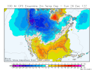
That’s ok, the more reliable 18Z GEFS is holding its own and actually has the intense cold advancing the furthest of any recent run into the MW late in the run:

View attachment 97708
Which, as you know Larry, is all we need to worry about right now.
 
Back
Top