Webberweather53
Meteorologist
View attachment 97649Gefs does look better then the OP in the pacView attachment 97650
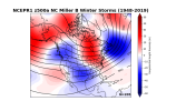
From my winter storm climatology page
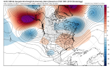
View attachment 97649Gefs does look better then the OP in the pacView attachment 97650


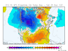
12Z GEFS cross polar flow brings frigid cold to our main source region as this is the coldest run up there yet. How far south would this cold air eventually get as it battles the zonal flow below it? Also, check out the N Atlantic blocking:
View attachment 97667
 Winter storm bound!
December 2017 esque
If by better you mean the southeast will be 30 or more degrees warmer on average then yes we will have a better winter. As far as snow you must be pulling our legs. I’d imagine you’ll have multiple weeks that would take years for most of us to equal in snow accumulation and snow days.So far this winter up here in Montana has been meh I wouldn’t be surprised if you guys down in the south have a better winter than me but I will say you guys deserve itView attachment 97624

Pics or it didn't happenOMG, just saw the 6Z CFS and it is MUCH colder for early to mid January!! More later.
... but what will really happen? ...The -NAO block really starting to show up on modeling strong today. I believe this will cause some changes over the next two days in the outcomes the models show for the medium range
You mind posting the spread for ILM
Pics or it didn't happen
Imo I like the change around AK vs a straight up +EPO but the ridge axis is centered over the Aleutians, which often wants to torch us
Imo I like the change around AK vs a straight up +EPO but the ridge axis is centered over the Aleutians, which often wants to torch us
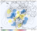
I can't put lipstick on a pig. That is horrible and if that look ends up verifying we'll still be a long way from anything good. That's an east based
No pics yet, but 6Z is by far the coldest yet l(so expect the next to not be as cold obviously) with it a whopping 8BN at Chicago, 7BN at NYC, 6 BN at RDU, 3BN at ATL, and 2BN at SAV for January 2-27! Wedges are raging during this run and Arctic dominates most of the E US.
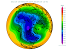
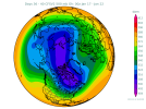
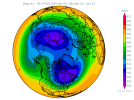
You are getting way too upended by the 360 he EPS. Especially when it’s MJO progression is slow which is a bias. Expect the continued -NAO begin to squash any SER.I can't put lipstick on a pig. That is horrible and if that look ends up verifying we'll still be a long way from anything good. That's an east based
-NAO, we want west based. That Aluetian ridge is an eye sore that's going to cause a -PNA on steriods. I can't spin that to anything good. Maybe some onset ice in a CAD event but the cold isn't even in southeast Canada or New England to provide us a legit CAD storm. I know we've been talking very late Dec or early Jan for anything good but if that Aluetian ridge ends up that strong in that location in late December that early January timeframe will quickly go to mid January. But that's just my opinion ?
Not gonna happen so don’t worry about it.I can't put lipstick on a pig. That is horrible and if that look ends up verifying we'll still be a long way from anything good. That's an east based
-NAO, we want west based. That Aluetian ridge is an eye sore that's going to cause a -PNA on steriods. I can't spin that to anything good. Maybe some onset ice in a CAD event but the cold isn't even in southeast Canada or New England to provide us a legit CAD storm. I know we've been talking very late Dec or early Jan for anything good but if that Aluetian ridge ends up that strong in that location in late December that early January timeframe will quickly go to mid January. But that's just my opinion ?
To my untrained eye there it's raising heights in the NAO region but it's east based. The ridge in AK, which is too far west, is trending stronger and lowering heights on the west coast even more. To me that looks like the wrong trends for the SE. Sure the more blocking up there will lead to colder weather in North America but it looks like it'll go to the wrong areas. You would do well in New Mexico. What am I missing there? I'm just taking it verbatim and realize it's probably wrong since it's too slow with the MJO, but if it were right I see that the end of December or 1st week of Jan flip may be in trouble.EPS has been slower to the punch and most bearish about the -NAO overall amongst the 3 major model suites, I think it's probably wrong in that regard and the stronger -NAO (which has been a consistent trend in the medium-range that's propagated deeper into the runs) should yield a cooler pattern overall compared to what it's showing atm.
Even still, today's run once again ticked stronger w/ the -NAO in the 10-15, closer to what the GEFS has had. I think the EPS's slower than verified MJO forecasts are hurting it.
View attachment 97684
I certainly hope it's not even close to being correct.Not gonna happen so don’t worry about it.
EPS has been slower to the punch and most bearish about the -NAO overall amongst the 3 major model suites, I think it's probably wrong in that regard and the stronger -NAO (which has been a consistent trend in the medium-range that's propagated deeper into the runs) should yield a cooler pattern overall compared to what it's showing atm.
Even still, today's run once again ticked stronger w/ the -NAO in the 10-15, closer to what the GEFS has had. I think the EPS's slower than verified MJO forecasts are hurting it.
View attachment 97684
