I get saved by the Lake Lanier warm bubble ??Ima just head over and cast my vote in your ZR poll…
Edit/ jk 6” of sleet. @GaWx will like
I get saved by the Lake Lanier warm bubble ??Ima just head over and cast my vote in your ZR poll…
That was a good one. I remember local Mets tracked that one confiedently from 6-7 days out. Like it couldn’t miss.I think the Christmas 2010 storm was first shown 10 days out, then went poof on the models and came back a few days before Christmas.
That’s wild. Our guys around here blew it off big time. Saying just a few snow flurries. Ended up getting like 4-6 out of it. Hrrr nailed the event.That was a good one. I remember local Mets tracked that one confiedently from 6-7 days out. Like it couldn’t miss.
Looks like a over running situation right there.View attachment 97617Interesting
Yeah, I've been watching this time period for our western states. I wouldn't be suprise in future runs if it expands eastLooks like a over running situation right there.
Meh, never mind the GFS just loses the coldIf that high pressure over Iowa can avoid scooting out or strengthens over the NE it could be a good CAD setup
Meh, never mind the GFS just loses the cold
That’s wild. Our guys around here blew it off big time. Saying just a few snow flurries. Ended up getting like 4-6 out of it. Hrrr nailed the event.
What's really wild is Baton Rouge has yet to reach 32 this season! Normally we'll hit that by late November. We got close a couple times, getting down to 34 one morning in mid November, but we have yet to hit the magic number. Maybe by year's end.Last December, the city of Atlanta had temps of 32°or below 11 days out of the month. If this pattern holds…it could be 0.
Sent from my iPhone using Tapatalk
What's really wild is Baton Rouge has yet to reach 32 this season! Normally we'll hit that by late November. We got close a couple times, getting down to 34 one morning in mid November, but we have yet to hit the magic number. Maybe by year's end.
Interesting thread. If you believe Huffman, don’t get too excited about the MJO…
Sent from my iPhone using Tapatalk
Great run on the GFS! Merry Torchmas Logan! ??Man that SE ridge is no joke this run View attachment 97618
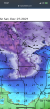
What's really wild is Baton Rouge has yet to reach 32 this season! Normally we'll hit that by late November. We got close a couple times, getting down to 34 one morning in mid November, but we have yet to hit the magic number. Maybe by year's end.
I don’t think you read his entire thread. Not saying I agree with him but he’s saying a pass through phases 7 8 1 hardly guarantees a cold pattern and even showed previous years where this mjo pass thru resulted in a mild se with all the cold focused west. Amplitude matters and some models are showing a weak wave entering 7-8I don't think the MJO is supposed to go into a favorable cold phase for SE US weather until we get to Phase 7 or 8 anyway. The earliest that's supposed to occur is end of December, which means we shouldn't be surprised if this region isn't that cold for Christmas week.
I don't think the MJO is supposed to go into a favorable cold phase for SE US weather until we get to Phase 7 or 8 anyway. The earliest that's supposed to occur is end of December, which means we shouldn't be surprised if this region isn't that cold for Christmas week.
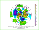
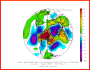
Great GFS run! ?
We hug! View attachment 97623
Where he’s from it won’t be fantasy for much longer ?Yay for some fantasy snow ?
Was there snow or ice members?This is exactly what we want to see right here. A stronger ridge that's also retrograding faster out into the Atlantic on later runs >>> faster -NAO development. EPS starting to look much more like the bullish GEFS
View attachment 97628
Maybe 5 with snow. Nothing specialWas there snow or ice members?
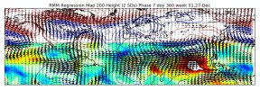
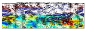
MJO phase 7-8 are great looks for us overall at this time of the year w/ big -EPO & -NAO. I think we'll see the models trend a little more towards this pattern in the coming week or two, but the -PNA may be there in some capacity regardless. That's not necessarily the end of the world, really just means we're more likely to get overrunning/CAD events and there could be some warm-ups from time to time. Fwiw, when you look at many of the biggest CAD/overrunning, they have higher, even slightly positive PNAs leading up to them that transition negative a day or two prior to the storm showing up.
View attachment 97630
View attachment 97629
What’s your reasoning?Hey guys as promised, you know I’ve been honking Jan.15th or later for our first winter storm E of the mtns for quiet some time. However, I told you I would update this December 12th if it should be sooner or later! I am now going with LATER with a time period of January 25th~ or later. Doesn’t mean winter is over I’m just trying to narrow in on when we may start tracking something of significance (greater than 3” snow or quarter inch ice). My next update will be on Christmas Eve to look at the pattern and models to see if things should be pushed back to February 1st or later. Thanks! ?
