• Hello, please take a minute to check out our awesome content, contributed by the wonderful members of our community. We hope you'll add your own thoughts and opinions by making a free account!

Pattern December, Make analogs relevant again

I agree with Webber, this will be a respectable cold snap but those numbers on the GFS are silly. Let's wait and see what the EPS brings us, I bet it is at least 10 degrees warmer than the GFS and CMC in the SE. Besides, last week at this time some GFS runs were showing us in the 60's and 70's.
 
Clearly there is going to be a ratings war with Mets in AL....and all you gotta do is say the "S" word for Christmas. Not a wise move by any of them.

That is the most un-Glen Burns thing I’ve ever heard.

After everybody completely blew the last storm we're seeing them be more aggressive; nobody wants to miss the next one. They'd rather be wrong about possible snow than not mentioning it and getting hammered..
 
After everybody completely blew the last storm we're seeing them be more aggressive; nobody wants to miss the next one. They'd rather be wrong about possible snow than not mentioning it and getting hammered..
Same here in Ga. I’ve heard the s word on WSBTV More the past 2 days then ever before.
 
Canadian Ensemble 10 day period starting Dec. 23...now THAT is a cold nation!
25395895_1514664145248858_1657441991491629409_n.png
JB says that's the coldest ensemble run , of any model, he's ever seen!!
 
Think about where we were the last two days at this time. We were kind of bummed that runs like 12Z & 18Z had the SW mess/SER keeping the SE from gettting cold even though we were hopeful for better runs ahead. Two nights ago, the 0Z GFS delivered the cold in a stunningly different run from prior runs. Many of us like myself were happy and smiling. Then the 6Z-18Z runs yesterday were back to SER/SW energy to some extent and took away our smiles.Then the magic suddenly returned with last night's 0Z GFS for the 2nd 0Z in a row! Well, unlike the two night ago 0Z being on an island, this time the 0Z was followed by more cold runs thank goodness! It looks to me like the SER/lingering SW US lingering energy problems are gone (I hope I'm not wrong) and we can now sit back, relax, and look forward to future runs with excitement rather than with worry. Don't forget that it is a rarity to see 1060-5 highs modeled run after run on all 3 major models, whether fake or not. I recommend folks take this rare opportunity for extraordinary excitement and just enjoy it as we don't know when we'll see runs like this again.

*Edited
 
Last edited:
The EPS is definitely warmer but it's come a long way from where it was earlier, at first it wasn't budging on it being very warm...
 
Think about where we were the last two days at this time. We were kind of bummed that runs like 12Z & 18Z had the SW mess/SER keeping the SE from gettting cold even though we were hopeful for better runs ahead. Two nights ago, the 0Z GFS delivered the cold in a stunningly different run from prior runs. Many of us like myself were happy and smiling. Then the 6Z-18Z runs were back to SER/SW energy to some extent and took away our smiles.Then the magic suddenly returned with last night's 0Z GFS! Well, unlike the two night ago 0Z being on an island, this time the 0Z was followed by more cold runs thank goodness! It looks to me like the SER/lingering SW US lingering energy problems are gone (I hope I'm not wrong) and we can now sit back, relax, and look forward to future runs with excitement rather than with worry.

One can only hope


Sent from my iPhone using Tapatalk
 
Put it this way, most of all models are in agreement now that it's going to get very cold, some models maybe warmer than others. But either way, it's going to get cold! Every model isn't going to show the same numbers from one model. Also, a possible storm system is still on the table as the cold blast is progressing south and east.
 
I definitely don't mind taking my chances with dry though, one of the most memorable snows that I've experienced was January 2014 when I was in Northwest Georgia. The forecast was for it to be too cold and dry for it to snow too much, it was thought that there might be a dusting of snow...

That's the first and only time I'll likely see it snowing at a pretty good clip with it in the upper teens. It wasn't ever really heavy, but it was a good clip.

And we all know about the traffic stories, due to how cold it was, the snow that did happen was causing roads to ice up. That was a crazy winter.
 
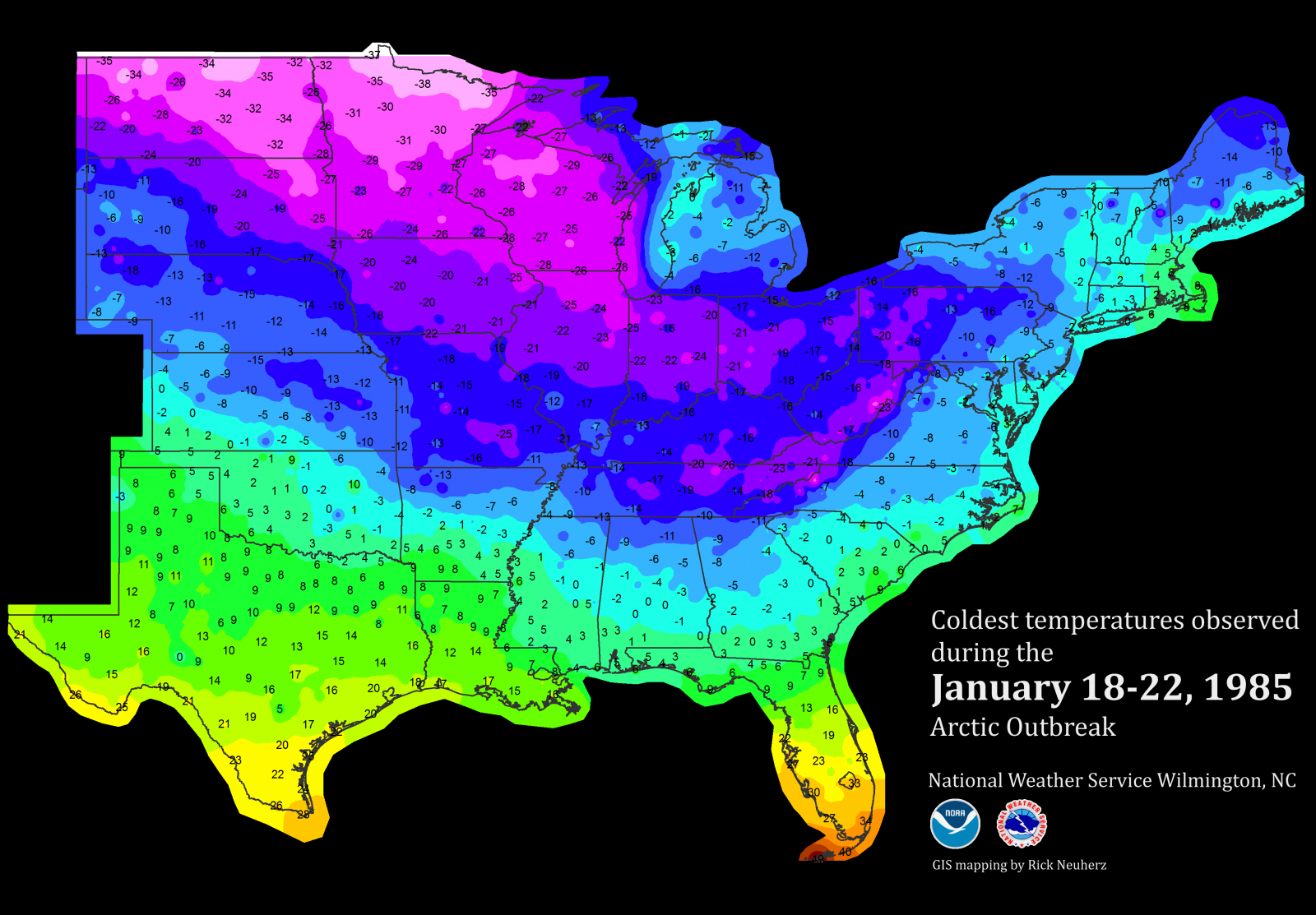
I will add as cold as these runs are being shown by the models I will point out temps are not as cold (close yes) as say the 83 arctic blast. Also I guess what gets me looking back there was no snow on the ground just true arctic outbreak... Amazing
 
I don't if this was answered. You're right but Webb is saying the GFS tends to radiate quite a bit too much over snowcover. It essentially overdoes it and it contributes to cold bias in winter. I thought that maybe it was modified to correct this but it doesn't appear so.

I don't know how the new upgrades addressed the snow cover issue either, but the GFS is still a northern stream biased model and still appears to have its cold bias as one gets further in the run (MR, LR).

Now with that said...the extreme HP being depicted, IF modeled correctly or very close to correctly, then the surface cold air will be very much close to fruition or even could be downplayed a bit. Very cold, dense arctic airmasses have actually been underestimated before WRT very cold dense SHP areas (850mb temps to SFC schemes are thrown off).

The CMC/EURO/GFS have beem consistent with one thing. Massive -EPO ridge translating to a very dense SHP downstream sliding into the Northern States towards the end of this week. Will it be record breaking? Probably not, but if it does reach this 1060mb or greater territory, one may have to give credence to the bitterly cold airmass in response to such extreme high pressures at the SFC.
 
I will add as cold as these runs are being shown by the models I will point out temps are not as cold (close yes) as say the 83 arctic blast. Also I guess what gets me looking back there was no snow on the ground just true arctic outbreak... Amazing
Good. We dont want 83 style cold. Just need it cold enough to bring us snow.
 
I will add as cold as these runs are being shown by the models I will point out temps are not as cold (close yes) as say the 83 arctic blast. Also I guess what gets me looking back there was no snow on the ground just true arctic outbreak... Amazing

Although Webb is 100% right about the GFS cold bias, others have pointed out that models often have trouble with modeling how far south low level very cold air will go with big and very strong Arctic highs. I think that the major 12/1983 and 1/1982 (snowjam) cold outbreaks are good examples of this. Has this problem been perfected? I don't know but I'd be wary about the possibility of it getting colder than even the coldest GFS runs have shown. This is no ordinary setup. I can't even recall anything like what we're seeing now, all 3 major models repeatedly showing these huge highs. Something highly unusual apparently is going to happen.
 
I don't know how the new upgrades addressed the snow cover issue either, but the GFS is still a northern stream biased model and still appears to have its cold bias as one gets further in the run (MR, LR).

Now with that said...the extreme HP being depicted, IF modeled correctly or very close to correctly, then the surface cold air will be very much close to fruition or even could be downplayed a bit. Very cold, dense arctic airmasses have actually been underestimated before WRT very cold dense SHP areas (850mb temps to SFC schemes are thrown off).

The CMC/EURO/GFS have beem consistent with one thing. Massive -EPO ridge translating to a very dense SHP downstream sliding into the Northern States towards the end of this week. Will it be record breaking? Probably not, but if it does reach this 1060mb or greater territory, one may have to give credence to the bitterly cold airmass in response to such extreme high pressures at the SFC.

OMG, I was typing the same message when you posted this!! Bizarre!
 
Although Webb is 100% right about the GFS cold bias, others have pointed out that models often have trouble with modeling how far south low level very cold air will go with big and very strong Arctic highs. I think that the major 12/1983 and 1/1982 (snowjam) cold outbreaks are good examples of this. Has this problem been perfected? I don't know but I'd be wary about the possibility of it getting colder than even the coldest GFS runs have shown. This is no ordinary setup. I can't even recall anything like what we're seeing now, all 3 major models repeatedly showing these huge highs. Something highly unusual apparently is going to happen.
Yes I agree models have been showing this to some degree for few days now it seems. Another it was not a transient shot of cold air it hung around for awhile which is unusual for out area anyway and reloaded a bit...Also I believe that was a 1060+mb high back then. Them in late Jan yet another blast came in late that month but not as cold

Some temps from B'ham
1983-12-24 25 4
1983-12-25 18 2
1983-12-26 27 5
1983-12-27 45 26
1983-12-28 50 32
1983-12-29 32 15
1983-12-30 26 9
1983-12-31 42 9

Edit to say the early 80's saw numerous cold outbreaks most transient but some good cold arctic thumps back then
 
I thought snowcover was the absolute best to reflect heat back out and keep warmth under it in the ground. Are you saying there is a known bias that the GFS is programmed incorrectly with that? Wow, we really need smarter people making our weather modeling.

I did some research, and I discovered that the GFS cold bias stems from its utilization of the Monin-Obukhov (MO) (1948) surface layer parameterization that describes turbulence in the surface layer. This scheme fails to produce turbulent fluxes in stable or intermediately stable regimes and can lead to unrealistically large decoupling between the surface and lower atmosphere (which thus leads to spuriously cold temperature forecasts). During extremely stable regimes as is often observed during the winter, especially over regions with fresh snow cover, 2 primary feedbacks work in conjunction to alter surface temperatures. Namely, downward sensible heat flux (a negative feedback) resulting from the increasing vertical temperature gradient which balances surface ground fluxes to moderate surface temperatures, and increasing atmospheric stability (a positive feedback). This positive feedback related to atmospheric stability grows at a faster rate than the aforementioned negative feedback associated with downward sensible heat flux and can become so strong that downward heat flux is essentially 0 in extremely stable regimes. Ground heat fluxes from upper soil temperature gradients acts as another mechanism to offset this positive feedback, but if a snow pack insulates the soil, this heat flux can be shut off entirely and lead to excessive cooling of surface temperatures. In highly stable situations, sub grid scale turbulent fluxes not resolved by coarse spectral NWP models including (but not limited to) cold air drainage, gravity waves, and surface inhomogeneities become the dominate sources of turbulence, and if these are not adequately captured by the model, then the surface temperatures will verify way too cold as we see time and time again in the GFS. Zheng et al (2017) proposed modifying the MO stability parameter and this seemed to reduce the severity of the cold bias in the GFS model but it still remains (& the model hasn't yet been upgraded w/ this stability parameter). The ECMWF's turbulent diffusion was artificially enhanced in the late 1990s and early 2000s to reduce these biases we observe in the GFS, especially in the winter.

See Zheng et al (2017) for more information: http://journals.ametsoc.org/doi/abs/10.1175/MWR-D-16-0438.1
It's a long paper but more than worth the read, especially considering this cold bias in the GFS is a daily occurrence and is likely happening yet again in real-time.
 
Last edited:
Back
Top