-
Hello, please take a minute to check out our awesome content, contributed by the wonderful members of our community. We hope you'll add your own thoughts and opinions by making a free account!
You are using an out of date browser. It may not display this or other websites correctly.
You should upgrade or use an alternative browser.
You should upgrade or use an alternative browser.
Pattern December Discussion
- Thread starter Storm5
- Start date
B
Brick Tamland
Guest
Supershow link said:See if this works:

Well, hello! I'd take that for Christmas Eve.
N
NorthGaWinter
Guest
Oh Canada
Storm5
Member
exactly what's being discussed . nice little overrunning .NorthGaWinter link said:Oh Canada
Of course it's the Canadian and their military blows, just like their op model
Sent from my SM-G900V using Tapatalk
N
NorthGaWinter
Guest
Lol so much potential. Way more fun than last December
Supershow link said:See if this works:
This clown map shows several inches of snow from just north of Brunswick, GA up along the coast to near Charleston. Whereas that would be awesome, that's not accurate as per the precip./850 mb maps. So, I have to question the accuracy of this clown.
B
Brick Tamland
Guest
SD link said:[quote author=Brick Tamland link=topic=2.msg636#msg636 date=1481217271]
Looks like just rain for me.
Yep, but I would take my chances with the cold vs the SE ridge in this type of scenario and we get a lot more wintry precip
[/quote]
I do like the number of chances showing up, and the shot we have at something the last half of the month with all these threats showing up. No guarantees, but it''s like the difference in Curry having the ball to take a last second three to win the game versus me. He might miss, but he has a much better shot at hitting it than me, and looks like Curry is going to have the ball.
Im fairly excited for the GEFS and Euro today. This usually starts the downward spiral to fail
GaWx link said:[quote author=Supershow link=topic=2.msg643#msg643 date=1481217623]
See if this works:
This clown map shows several inches of snow from just north of Brunswick, GA up along the coast to near Charleston. Whereas that would be awesome, that's not accurate as per the precip./850 mb maps. So, I have to question the accuracy of this clown.
[/quote]
Can't have a good weather forum discussion without a good Clown... 8)
Storm5
Member
Re: December Discussion

Sent from my SM-G900V using Tapatalk
12z gefs is about like the last 24 hours of gefs runs. Lots of potential . Multiple blasts of cold and many systems. supportive of the H5 pattern on the opSD link said:Im fairly excited for the GEFS and Euro today. This usually starts the downward spiral to fail

Sent from my SM-G900V using Tapatalk
Dang we can't even score on the clown map. Looks good for the Ohio Valley and Northeast though !
Storm5
Member
why would you want to score with a clown map? who cares, it's the overall pattern that mattersSoutheastRidge link said:Dang we can't even score on the clown map. Looks good for the Ohio Valley and Northeast though !
Sent from my SM-G900V using Tapatalk
B
Brick Tamland
Guest
SD link said:Im fairly excited for the GEFS and Euro today. This usually starts the downward spiral to fail
whatalife
Moderator
why would you want to score with a clown map? who cares, it's the overall pattern that mattersStorm5 link said:[quote author=SoutheastRidge link=topic=2.msg653#msg653 date=1481218877]
Dang we can't even score on the clown map. Looks good for the Ohio Valley and Northeast though !
Sent from my SM-G900V using Tapatalk
[/quote]
He's lost in translation...
Sent from my iPhone using Tapatalk
exactly what's being discussed . nice little overrunning .Storm5 link said:[quote author=NorthGaWinter link=topic=2.msg645#msg645 date=1481217757]
Oh Canada
Of course it's the Canadian and their military blows, just like their op model
Sent from my SM-G900V using Tapatalk
[/quote]
The CMC scored some victories in the last couple of years, especially in CAD events!
Storm5 link said:agreed , in fact I'm starting to get on the 4-6 weeks of a general cold pattern before it all goes to hell late January. Obviously not sustained cold for 4-6 weeks. but enough of a cold pattern to give us chances vs having to wait on a pattern shuffle. I was sold on a pattern breakdown before the new year, I have doubts now
The current and forecasted MJO is in full agreement with cold as it is and will continue to be within the circle for awhile per the EPS. Within or just outside the circle (i.e., low amplitude), especially on the left side, is what one wants to see for the best shot at a sustained cold pattern as it has a better correlation to SE US cold than being well outside the circle:
http://www.cpc.ncep.noaa.gov/products/precip/CWlink/MJO/CLIVAR/ECMF_phase_51m_full.gif
Historic examples of low amplitude MJO (mainly either inside or just outside the circle) when the SE was cold:
Jan 1977 (red line): http://www.bom.gov.au/climate/mjo/graphics/archive/MJO_phase/197701.phase.90days.gif
Jan 1982 (red line): http://www.bom.gov.au/climate/mjo/graphics/archive/MJO_phase/198201.phase.90days.gif
Dec 1983 (blue line): http://www.bom.gov.au/climate/mjo/graphics/archive/MJO_phase/198310.phase.90days.gif
Early Jan of 1988 (red line): http://www.bom.gov.au/climate/mjo/graphics/archive/MJO_phase/198801.phase.90days.gif
Dec of 1989 (blue line): http://www.bom.gov.au/climate/mjo/graphics/archive/MJO_phase/198910.phase.90days.gif
Dec of 2000 (blue line): http://www.bom.gov.au/climate/mjo/graphics/archive/MJO_phase/200010.phase.90days.gif
Jan of 2010 (red line): http://www.bom.gov.au/climate/mjo/graphics/archive/MJO_phase/201001.phase.90days.gif
Dec of 2010 (blue line): http://www.bom.gov.au/climate/mjo/graphics/archive/MJO_phase/201010.phase.90days.gif
Jan of 2014 (red line): http://www.bom.gov.au/climate/mjo/graphics/archive/MJO_phase/201401.phase.90days.gif
B
Brick Tamland
Guest
Wow, 9 and 14 please!
Storm5
Member
Re: December Discussion
12z euro keeps the PV further north next week vs the gfs
Sent from my SM-G900V using Tapatalk
12z euro keeps the PV further north next week vs the gfs
Sent from my SM-G900V using Tapatalk
Weatherlover92 link said:[quote author=Bones link=topic=2.msg629#msg629 date=1481216795]
Maps Maps Maps Please !!!
First Arctic Blast

Here is 12z Euro at same time:

Storm5
Member
this is a huge difference
12z gfs

12z euro

Sent from my SM-G900V using Tapatalk
12z gfs

12z euro

Sent from my SM-G900V using Tapatalk
Storm5
Member
gonna be a fun 12z euro finish with energy coming out of the rockies
Sent from my SM-G900V using Tapatalk
Sent from my SM-G900V using Tapatalk
Why did Fox News just say "could be the first polar vortex of the season". Man, here we go again.
Looks to me like more of a thunderstorm threat towards the end - 60's to Nashville??? Meh...cold air chasing left over moisture at endStorm5 link said:gonna be a fun 12z euro finish with energy coming out of the rockies
Sent from my SM-G900V using Tapatalk

Storm5
Member
Re: December Discussion
not a bad run at all nice epo and tries to bridge over the top which would be so sweet .

Sent from my SM-G900V using Tapatalk
not a bad run at all nice epo and tries to bridge over the top which would be so sweet .

Sent from my SM-G900V using Tapatalk
Storm5
Member
Looks to me like more of a thunderstorm threat towards the end - 60's to Nashville??? Meh...cold air chasing left over moisture at endSupershow link said:[quote author=Storm5 link=topic=2.msg671#msg671 date=1481222970]
gonna be a fun 12z euro finish with energy coming out of the rockies
Sent from my SM-G900V using Tapatalk
[/quote]
I'm worried about what type of pattern sets up more so than what an op run spits out at the surface
Sent from my SM-G900V using Tapatalk
W
WeatherLC
Guest
Those last images seem to have a CAD signature.Brick Tamland link said:Wow, 9 and 14 please!
Sent from my iPhone using Tapatalk
Euro is 74 next Saturday....golf time!
Looks to me like more of a thunderstorm threat towards the end - 60's to Nashville??? Meh...cold air chasing left over moisture at endStorm5 link said:[quote author=Supershow link=topic=2.msg673#msg673 date=1481223480]
[quote author=Storm5 link=topic=2.msg671#msg671 date=1481222970]
gonna be a fun 12z euro finish with energy coming out of the rockies
Sent from my SM-G900V using Tapatalk
[/quote]
I'm worried about what type of pattern sets up more so than what an op run spits out at the surface
Couldn't agree more - You and other long timers on here are much more adept at presenting the "science" of why things are than I could ever hope too. I am doing good just to paste a thumbnail image of what I perceive people like to see ;D
Sent from my SM-G900V using Tapatalk
[/quote]
Storm5
Member
I would love it to be that warm next weekend honestly. I've got lots of stuff to do outsideSD link said:Euro is 74 next Saturday....golf time!
Sent from my SM-G900V using Tapatalk
Storm5
Member
Re: December Discussion
[/quote]
I'm worried about what type of pattern sets up more so than what an op run spits out at the surface
Couldn't agree more - You and other long timers on here are much more adept at presenting the "science" of why things are than I could ever hope too. I am doing good just to paste a thumbnail image of what I perceive people like to see ;D
Sent from my SM-G900V using Tapatalk
[/quote]
[/quote]
your good a good job of that. can you right click the image to blow it up? download tapatalk , it's so easy to upload images with
Sent from my SM-G900V using Tapatalk
Looks to me like more of a thunderstorm threat towards the end - 60's to Nashville??? Meh...cold air chasing left over moisture at endSupershow link said:[quote author=Storm5 link=topic=2.msg675#msg675 date=1481224183]
[quote author=Supershow link=topic=2.msg673#msg673 date=1481223480]
[quote author=Storm5 link=topic=2.msg671#msg671 date=1481222970]
gonna be a fun 12z euro finish with energy coming out of the rockies
Sent from my SM-G900V using Tapatalk
[/quote]
I'm worried about what type of pattern sets up more so than what an op run spits out at the surface
Couldn't agree more - You and other long timers on here are much more adept at presenting the "science" of why things are than I could ever hope too. I am doing good just to paste a thumbnail image of what I perceive people like to see ;D
Sent from my SM-G900V using Tapatalk
[/quote]
[/quote]
your good a good job of that. can you right click the image to blow it up? download tapatalk , it's so easy to upload images with
Sent from my SM-G900V using Tapatalk
I would love it to be that warm next weekend honestly. I've got lots of stuff to do outsideStorm5 link said:[quote author=SD link=topic=2.msg678#msg678 date=1481224657]
Euro is 74 next Saturday....golf time!
Sent from my SM-G900V using Tapatalk
[/quote]
Stop wearing shorts and its not cold
Storm5
Member
fear the PVStarburst link said:Why did Fox News just say "could be the first polar vortex of the season". Man, here we go again.
Sent from my SM-G900V using Tapatalk
bigstick10 link said:[quote author=SD link=topic=2.msg678#msg678 date=1481224657]
Euro is 74 next Saturday....golf time!
Oh why not, wouldn't be surprised. Although I think the Euro might be out to lunch.
[/quote]
I actually agree a little bit. At 240 on the 0z run there was a low near Chicago at 240 on the 12z run its near Denver..
Those last images seem to have a CAD signature.GainesvilleWX link said:[quote author=Brick Tamland link=topic=2.msg663#msg663 date=1481220820]
Wow, 9 and 14 please!
Sent from my iPhone using Tapatalk
[/quote]
That's what I was thinking as well when looking at that. Either way it's nice to see so early in the season.
Anyone care to explain why someone might be inclined to get excited looking at the picture of the 12z Euro at 24 hours from now (some blue color) vs the forecast Euro at 240 hours (lots of green color)?


Supershow link said:Anyone care to explain why someone might be inclined to get excited looking at the picture of the 12z Euro at 24 hours from now (some blue color) vs the forecast Euro at 240 hours (lots of green color)?
These are showing the strat pv at 50mb. It looks like its being split with a lobe setting up over the US which should correspond to the troposphere following suit at some point. Its also nice to see as the Euro for a time was showing the strat PV strengthening and contracting to the pole
Storm5
Member
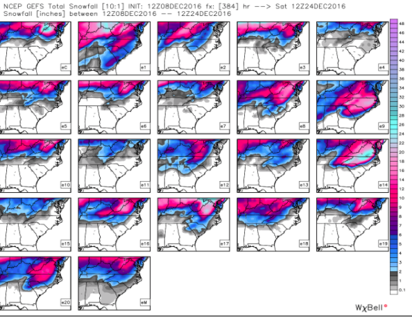
12z eps is very active the 15th-20th
Sent from my SM-G900V using Tapatalk
Sent from my SM-G900V using Tapatalk
whatalife
Moderator
Storm5 link said:12z eps is very active the 15th-20th
Sent from my SM-G900V using Tapatalk
Looks fun to say the least.
Sent from my iPhone using Tapatalk
SD link said:[quote author=Supershow link=topic=2.msg693#msg693 date=1481227565]
Anyone care to explain why someone might be inclined to get excited looking at the picture of the 12z Euro at 24 hours from now (some blue color) vs the forecast Euro at 240 hours (lots of green color)?
These are showing the strat pv at 50mb. It looks like its being split with a lobe setting up over the US which should correspond to the troposphere following suit at some point. Its also nice to see as the Euro for a time was showing the strat PV strengthening and contracting to the pole
[/quote]
Thanks for the explanation SD. IF this comes to fruition I would think it would be another piece available to facilitate our Winter chances down the line.
Sent from my iPhone using Tapatalk