GeorgiaGirl
Member
Was this morning the first 6z run that looked decent?
I started to go back and forth from the 12z and 6z and the 6z had a low on the gulf coast, it was just too warm.
Was this morning the first 6z run that looked decent?
Weeks... you know how a ATL works.And ATL will lose power for days too.


I see the GFS is being stupid, has the LP off the coast of Fl/Ga but then redevelops inland and runs it up the coastal plain.... that ain't happening if that wedge verifies, the lp would be further east and more of Cen NC would be in play. IF that HP verifies....
Yep it says what winter stormAnd the FV3 is different.... shocker
Our little clipper system is still alive and well. Going to be tough to get snow since boundary layer temps are the issue here but if we can get those to cooperate there could be some snow showers across the area.

View attachment 7792

.png")


Love it
Sent from my iPhone using Tapatalk
12z CMC has that 2nd piece of energy coming down as well.
I could see that for sureIt's early I know and anything can happen but I'm getting that CAD over-performing and models will catch up kind of feeling...... just a feeling

What was Dec 02? A #3Based on what I've noted throughout the observed record in NC, for Charlotte in particular the 3 best types of winter storms if you want a big snow/ice event are:
1) overunning events (Jan 1988)
2) Cut-off ULLs (Feb 1969 & Feb 2004)
3) Deep, cold CAD events (Dec 1930 & Feb 12-13 2014)
There's obviously some overlap between these especially storm types 1 & 3, and it's definitely looking more & more like whatever storm manages to affect the Carolinas and the rest of the southeast (if any) will be of "type" I or III. Here's to hoping for an amazing overrunning or deep CAD event; I'll take whatever I can get especially in early December.

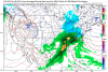
Only if they show snow over me.Do you guys find these maps useful?View attachment 7813
")
So no?Only if they show snow over me.
Seriously, sure.
Do you guys find these maps useful?View attachment 7813
Fingers cross. Hopefully it will also start trending south.Euro out to 168. Shows some overrunning in AK and west TN that wasn't there on 0z. Let's see where it goes...
Overrunning in Alaska? H5 must be a mess this runEuro out to 168. Shows some overrunning in AK and west TN that wasn't there on 0z. Let's see where it goes...
December 2002 was definitely a pretty big CAD event/#3, just not quite cold enough to produce several inches of front end snow thumping before going to IP/ZR like Dec 1930 & Feb 2014 did.What was Dec 02? A #3
Of course, those particular maps are helpful. Looking at what's going on up at H5 is one of the things that's most important as to what could happen down below.Do you guys find these maps useful?View attachment 7813