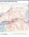
One concern I do have with that cluster of decaying convection over MS and AL is that its outflow boundary will only enhance the low-level helicity later today, thus increasing the tornado threat.
-
Hello, please take a minute to check out our awesome content, contributed by the wonderful members of our community. We hope you'll add your own thoughts and opinions by making a free account!
You are using an out of date browser. It may not display this or other websites correctly.
You should upgrade or use an alternative browser.
You should upgrade or use an alternative browser.
BufordWX
Member
gawxnative
Member
None that I have found with multiple outbreaks. There were significant outbreaks in 1957 (18-20) and the Christmas 1964 outbreak (GA/SC)Early 2000s late 1990s might have.
HSVweather
Member
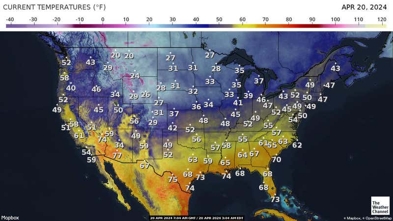
65/64 in MadisonSun is breaking out in Marshall County. 70/68 here
Sharp contrast along the boundary off the southern extent of the rain mass. Noticed In Lamar county it’s 60 in Detroit and 70 in Vernon.
The 15z HRRR tries to take me out.
None that I have found with multiple outbreaks. There were significant outbreaks in 1957 (18-20) and the Christmas 1964 outbreak (GA/SC)
Yeah, this December definitely feels like uncharted waters in terms of the number of significant severe weather events.
Even 1 significant severe weather event in December is highly unusual, let alone several.
65/64 in Madison
Sharp contrast along the boundary off the southern extent of the rain mass. Noticed In Lamar county it’s 60 in Detroit and 70 in Vernon.
I had to double check to make sure hou weren't talking about *DETROIT* Detroit. ?
Nothing would surprise me any more with this wild month.
HSVweather
Member
Haha, yep, both in Lamar county Alabama. 21 miles apartI had to double check to make sure hou weren't talking about *DETROIT* Detroit. ?
Nothing would surprise me any more with this wild month.
ALHammerWx
Member
- Joined
- Jan 4, 2017
- Messages
- 61
- Reaction score
- 117
Sun breaking out Blount County AL. 73
Z
Zander98al
Guest
??. It's nowcast time arc, don't look at those silly modelsWell, ahem.
Z
Zander98al
Guest
Also sun is out here in southern Birmingham. (Homewood) file is to big to upload my pic it says lol
droptines35758
Member
Raining in Athens. I’d like to keep it that way.
I have a temp of 72 and dp 68. Definitely muggy feel outside.
Z
Zander98al
Guest
All the moisture and rain from this morning has dried up and ascended into the atmosphere. Might have a legit shot at getting in the 2500-3000 sbcape range here in central Alabama.
tennessee storm
Member
Zander. See the 12zeuro for weekend . ? Yet If instability slightly underdone , that s a higher end threat than today’s threatAll the moisture and rain from this morning has dried up and ascended into the atmosphere. Might have a legit shot at getting in the 2500-3000 sbcape range here in central Alabama.
Darklordsuperstorm
Member
At current location in Hoover cloud cover is vanishing. Rapidly.
Z
Zander98al
Guest
Haven't checked tbh. Would like to get through this event before I really look at the next oneZander. See the 12zeuro for weekend . ? Yet If instability slightly underdone , that s a higher end threat than today’s threat
tennessee storm
Member
Ageee 100 percent. Just saying it appears have higher ceilingHaven't checked tbh. Would like to get through this event before I really look at the next one
HSVweather
Member
HSVweather
Member


Dewpoint Dan
Member
Beautiful
76 degrees here at the house in Hoover. I cut the grass today and was soaking wet when finished. I don’t think I have ever cut the grass this time of year. I don’t think instability will be an issue for sure.
Z
Zander98al
Guest
Storms near the Memphis radar are starting to rotate
Showmeyourtds
Member
Hell, its partly sunny in Atlanta now. I know most of this activity will make it over this way after it gets dark, but I was not expecting sun today at all. May even hit 70.
Avalanche
Member
I know dynamics are different, but one area the Apps kind of help out here.Hell, its partly sunny in Atlanta now. I know most of this activity will make it over this way after it gets dark, but I was not expecting sun today at all. May even hit 70.
Dewpoint Dan
Member
Its already hit 70 in Atlanta today.Hell, its partly sunny in Atlanta now. I know most of this activity will make it over this way after it gets dark, but I was not expecting sun today at all. May even hit 70.
bigstick10
Member
Z
Zander98al
Guest
Here we go. Let the show begin.
Avalanche
Member
Talk about continental divide.
Z
Zander98al
Guest
Two hooks already. These are bout to go boom
Z