• Hello, please take a minute to check out our awesome content, contributed by the wonderful members of our community. We hope you'll add your own thoughts and opinions by making a free account!

Severe December 28th -new years possible severe weather event.

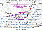
Might be a spin up in this area. Shear is increasing as it gets dark out. And there's already around 1000-1500 cape in that area. A lot of those cells are already spinning just not tight.Screenshot_20211228-181319.png
 
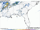
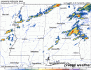
Update on tommorow. HRRR is doubling down on a more volatile setup. Cape now reaching around 2000 and over in central Alabama. Shear is looking a good bit better. With the surface low being more defined now than previously thought. A enchanced area is needed soon. Screenshot_20211228-193725.pngScreenshot_20211228-193711.pngScreenshot_20211228-193619.png
 

Attachments

  • Screenshot_20211228-193535-340.png
    Screenshot_20211228-193535-340.png
    1.5 MB · Views: 19
@Arcc what do you think of tomorrow nights event? Overproducer or dud lol?

Honestly, normally I would say a slight risk with this setup would suffice, but on the other hand the over producing event earlier this month has me spooked. Usually when setups over produce, they continue to over produce. This setup is giving me vibes of a setup in either February or March in 2019 when I didn’t think much of that little event which turned out to be a supercell fest. While thankfully the tornadoes were on the weaker side, one tracked within a half mile of my house.
 
Honestly, normally I would say a slight risk with this setup would suffice, but on the other hand the over producing event earlier this month has me spooked. Usually when setups over produce, they continue to over produce. This setup is giving me vibes of a setup in either February or March in 2019 when I didn’t think much of that little event which turned out to be a supercell fest. While thankfully the tornadoes were on the weaker side, one tracked within a half mile of my house.
What makes me nervous is all the simulated radar showing tons of isolated kidney beans. I'm afraid it'll turn into a big event very quickly. And not many people will get much warning.
 
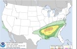
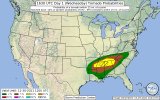
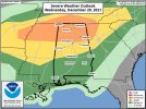
I could see a pocket of enhanced somewhere in Central N. Central Alabama and the overall slight expanded a little bit to both east and west of original outlook posted earlier
 
I'm still seeing a cluttered mess down towards Birmingham and points south, which is a positive for the northern parts of Alabama. This seems to be the new common for these setups. Crap part is you never know until the day of, if it comes to fruition. If there is no development to the south, well... the north suffers the consequences, but we've been saved time and time again by it. Hopefully it can rain itself out for the folks to the south and spare the damage and loss of life.


Sent from my Armor 9 using Tapatalk
This event wensday 29th, shouldnt be too cluttered actually, (the new years one might be). There's a lot of dry air aloft. And not a strong cold front or forcing to get a bunch of precip going. This kinda reminds me of pop up summer showers. But with more dry air, and a bit more forcing lol.
 
This event wensday 29th, shouldnt be too cluttered actually, (the new years one might be). There's a lot of dry air aloft. And not a strong cold front or forcing to get a bunch of precip going. This kinda reminds me of pop up summer showers. But with more dry air, and a bit more forcing lol.
The interesting thing is. HRRR has shown some decent rotating updrafts along a boundary into Tennessee and Alabama. That may be the best axis for moisture and shear combo, but less of a renegade cell threat. Two main threat areas imo, the boundary to the north with less instability but a bit more shear and then to the immediate south with pop up confluence cells.
 
Call it hopeful for the north Alabama area but, that screams southern clutter, cutting inflow and moisture return to the possibilities of storms to the north. Not a guarantee, but looks highly probable. I agree the atmospheric potential will be high in north Alabama, should the north pop before the southern fringes there are certainly possibilities for dangerous storms. Based off of past systems and some hope for the northern region, I'm going with the most significant event to the south. Not ruling out some svr storms to the north. My thoughts.... Certainly Stay weather aware, we will see soon enough! Stay safe everyone in the region!

Sent from my Armor 9 using Tapatalk
 
The ARW is wayyy more bullish on directional shear this run. Gonna look through the others.

Edit: the other WRF shows about the same as does the 3km NAM.
 

Attachments

  • 3B5A9B5C-10FF-4F31-947A-FB8E6B770943.jpeg
    3B5A9B5C-10FF-4F31-947A-FB8E6B770943.jpeg
    512.1 KB · Views: 34
  • 12C5A848-79FD-49F9-B45D-C4FD6095F1DC.jpeg
    12C5A848-79FD-49F9-B45D-C4FD6095F1DC.jpeg
    650.7 KB · Views: 34
Last edited:
I’m not sure how much stock to put into this, but this is interesting.

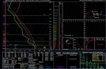
That is concerning; it’s been pretty decent in the past. Looking through the WRFs, the best instability and shear line up pretty well with that bullseye and to the SW as the low level jet cranks just after dark. If convection could sustain itself, there could be a few hours of really dangerous weather in that area with sbcape of 1500-2000 and 0-1km helicity 250-300.
 
Back
Top