• Hello, please take a minute to check out our awesome content, contributed by the wonderful members of our community. We hope you'll add your own thoughts and opinions by making a free account!

Severe December 28th -new years possible severe weather event.

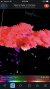
About to be go time. When sun sets.
Rotation rapidly increasing in the upper levels in the storm near Hackleburg.
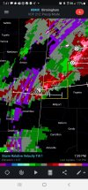
Coincinding with the srh helicity increase moving in from the northwest. Feel like there's about to be more rotating soon as the night goes on.
 
I wonder why this watch doesn’t include Birmingham? I guess they are thinking the threat there will be later…

There was a MD for Central MS earlier where the SPC noted decreasing convergence/forcing was a problem with southern extent, as the main shortwave is passing through TN.

I suspect, for now, this same issue is translating over into Central AL.
 
Man that cell south of Russellville says Warning all day. That's pretty well wrapped up and Columbus is not looking at it from a far distance. At least svr. With possibilities of a tornado. Geesh..

Sent from my Armor 9 using Tapatalk
 
Man that cell south of Russellville says Warning all day. That's pretty well wrapped up and Columbus is not looking at it from a far distance. At least svr. With possibilities of a tornado. Geesh..

Sent from my Armor 9 using Tapatalk

1e9284531346ab963c5cebff56b020cb.jpg


Sent from my iPhone using Tapatalk
 
Looks like the meso low formed near the Memphis area. See what that does. Overall most rotation has been broad tonight. Which is a good thing. Curious to the evolution over central Alabama later though
 
Looks like the meso low formed near the Memphis area. See what that does. Overall most rotation has been broad tonight. Which is a good thing. Curious to the evolution over central Alabama later though

Yeah, fortunately the best ascent has failed to align with the best instability, so far.

That and the lack of a well defined surface low (as the flow remains somewhat veered) is keeping storm organization in check.

But I don't want to jinx what's been a good trend (*knocks on wood*)
 
The storm right below the Guin storm is Severe Warned probably could progress as well if atmosphere is similar
 

Attachments

  • Screenshot_20211229-194130_RadarScope.jpg
    Screenshot_20211229-194130_RadarScope.jpg
    928.5 KB · Views: 20
Big supercell moving northeast to Alabama. Looks a bit suscpicousScreenshot_20211229-185915.png
 
It's taking it's time. But it's developing a decent mesocyclone. Wrapping up.Screenshot_20211229-190832.png
 
I used to drive thru winfield on the way to my hunting club when we had land over that way. Really hope the damage there is not bad.
 
That cell ^ needs a warning. Best developed cell all day. Rotation is getting tight on it now.
 
Back
Top