Probably about to get warned.
-
Hello, please take a minute to check out our awesome content, contributed by the wonderful members of our community. We hope you'll add your own thoughts and opinions by making a free account!
You are using an out of date browser. It may not display this or other websites correctly.
You should upgrade or use an alternative browser.
You should upgrade or use an alternative browser.
Z
Zander98al
Guest
Here we go. Headed straight for familiar areas. 
Z
Zander98al
Guest
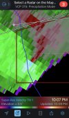
Possible debris 


HSVweather
Member
 I hope this stays south of Tuscaloosa with the basketball game ongoing, it appears to be going south of town
Z
Zander98al
Guest
Tornado warning
Z
Zander98al
Guest
Tornado warning in dekalb county. That's a very good inflow and outflow. 
Z
Zander98al
Guest

Z
Zander98al
Guest
Tornado OTG.
Z
Zander98al
Guest
Tornado warning for tuscaloosa and Bibb!!
That one is a isolated cell on bottom of line and looks pretty tight rotationTornado warning for tuscaloosa and Bibb!!
HSVweather
Member
damage video from Winfield
HSVweather
Member
 Circulation moving toward Gasden, AL
incredible rainfall rates with the main line moving through...KCHA logged 0.25" in a 3-minute period between 0215z and 0218z. that works out to a rainfall rate of 5" per hour.
BufordWX
Member
80% chance of new watch…
Z
Zander98al
Guest
It's past my bedtime ?. I'm going to watch for a bit longer, and then I'm going to schleep. Should be all clear now in north Birmingham.
It's past my bedtime ?. I'm going to watch for a bit longer, and then I'm going to schleep. Should be all clear now in north Birmingham.
9pm is past your bedtime?
Do you get up extremely early in the morning for work?
Z
Zander98al
Guest
I wake up at 4 in the morning lol so yes. I need my schleep9pm is your bedtime?
I wake up at 4 in the morning lol so yes. I need my schleep
I figured that after I posted (just edited my comment).
I couldn't do it, lol.
Nicole Leath
Member
Could you update on this please? I live a mile due north of Rainbow City.View attachment 99809Circulation moving toward Gasden, AL
HSVweather
Member
No tornado warning and the e circulation stayed broadCould you update on this please? I live a mile due north of Rainbow City.

HSVweather
Member
 Central Alabama shows more development overnight on the 01Z HRRR
Anyone watching that cell south-west of Charlotte NC?
Jessy89
Member

This one just crossed into NC wonder if those high mountains made it rotate
Sent from my iPhone using Tapatalk
B
Brick Tamland
Guest
Not sure if we will have anything severe my way, but I hate that if we do it will come overnight.
BufordWX
Member

bingcrosbyb
Member
New tornado warning for Calhoun County.
- Joined
- Jan 2, 2017
- Messages
- 1,567
- Reaction score
- 4,282
You beat me to it...gonna be radar watching in late December after all unfortunately

Rotation strengthening in the storm nearing Shelby county. Nice BWER on MXX.
RIGHT OVER MY HOUSE WITH MY FAM THERE AND I AM AT WORK IN CHELSEARotation strengthening in the storm nearing Shelby county. Nice BWER on MXX.
- Joined
- Jan 5, 2017
- Messages
- 3,803
- Reaction score
- 6,052
These spin-ups are very quick. Hardly much notice or lead times on the warnings.
- Joined
- Jan 2, 2017
- Messages
- 1,567
- Reaction score
- 4,282
That's a good point! Heed the watches and be ready. I'm staying up till it passes here for sure.These spin-ups are very quick. Hardly much notice or lead times on the warnings.
BufordWX
Member
Might be on the ground.
