BPATL
Member

I just feel like it's gonna be weaker wave eventually turning into a storm.What makes you think that?
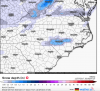
 18 GFS ice totals
Yeah, I think this storm is just the appetizer and setting up for bigger things a few days later.I'll tell you guys, there are 3-5 chances of storms even after this event. Things are really shaping up to be interesting into January if the GFS is close to being right.
We have a thread for January setup, to talk about that stuff too!

Looks similar to 12z18z Canadian:
Nice 8" lollipop over Augusta! LolGfs very similar to the euro
Sent from my SM-G955U using Tapatalk
That's acceptable down here
") Some coating, without all the tops breaking out of trees, and power lines down. Put some sleet in on it and good times. Climo likes this time frame, at least around Atl. That's been my experience. T
Some coating, without all the tops breaking out of trees, and power lines down. Put some sleet in on it and good times. Climo likes this time frame, at least around Atl. That's been my experience. TI recall you and I watching the Canadian during the January 2011 storm, and it perfectly nailed the storm. The other models had more ice than snow, while the Canadian had more snow than ice.18z Canadian:
I recall you and I watching the Canadian during the January 2011 storm, and it perfectly nailed the storm. The other models had more ice than snow, while the Canadian had more snow than ice.
Let's say I ended up with nearly 7" with a slight glaze of ice to coat it.
The Canadian also initially sniffed out the February 2010 storm. Keep that in mind, too.

Car battery, and an inverter if you don't have a generator. Be sure you have some way to heat up food. Camp stove, whatever. Eating cold out of the can, if you have any food in the house, for a week to 10 days gets old, lol. Stores won't be open, and people in Apts will be in dire straights if they get over an inch in a city.Going to be bad when 10's of thousands (if not more) of people in Georgia and South Carolina can't watch the games on New Years due to lack of power! Not that it matters really, Bama has it all wrapped up anyway.
You've got to dance with the z devil to get an epic sleet storm, lol. I'd much rather get snow to turn to sleet like the 4 incher in Atl back in the late 70's. One like this could move back and forth during the whole event, and I love that another is on it's heels for early week. We could get another 3fer if we are lucky. Saw one of those down here in the 90's, where we had a minor zr event, then a middling mixed event, then a nice finisher of heavy sleet and snow a few days away from each other. The stuff from each storm was still there for the next. Every once in a while nature gives something for each kind of lover...thou I've never met a zr lover.Hoping the CMC will set the trend. Need to avoid the ice. Plus Tony will get his sleet if it's right lol.
How does this compare to the 12z?Ruh roh, GEFS is slightly wet for it's mean for some:
Yeah, of all of us they know not to take a strong cad lightly. I've seen bad times with a less powerful high providing the cold. A good one goes well into Ala, lol. And this could be a good one.I love how ffc only mentions NE GA as possible ZR ok.
Slightly drier than 12z with a similar axis of heaviest precip. No big changes that I saw.How does this compare to the 12z?
I agree and one of the biggest things I look for when it comes to the strength of the wedge is 10m (sfc) winds. Pressure chart yes, but winds are more realistic imho. The NE fetch goes into Bama and all the way to the FL panhandleYeah, of all of us they know not to take a strong cad lightly. I've seen bad times with a less powerful high providing the cold. A good one goes well into Ala, lol. And this could be a good one.
Is the 18z Canadian model stronger than 12z Canadian run18z Canadian:


With the Jan system this year it was the most amped (and warmest) and held serve. I believe it picked up on that trend even before the NAM did.
18Z NAVGEM definitely way more amped.
FFC tends to be conservative because so many schools/businesses/organizations in metro Atlanta - heck, even here in Athens - link their inclement weather policies directly to NWS watches/warnings (at least that was the case when I was responsible for risk management at a corporate travel company in Atlanta from 2001-2008). In fact public school districts tend to use such NWS advisories as the sole trigger for class cancellations...so you better be danged sure you're right if you make a prediction that disrupts the lives and commerce of a metroplex containing six million people. I don't envy their job one single bit.Oh believe me, FFC used to be worse with conservatism.

There are some counties that are on school breakFFC tends to be conservative because so many schools/businesses/organizations in metro Atlanta - heck, even here in Athens - link their inclement weather policies directly to NWS watches/warnings (at least that was the case when I was responsible for risk management at a corporate travel company in Atlanta from 2001-2008). In fact public school districts tend to use such NWS advisories as the sole trigger for class cancellations...so you better be danged sure you're right if you make a prediction that disrupts the lives and commerce of a metroplex containing six million people. I don't envy their job one single bit.


Check out the images from the nam I posted. That screams wedge. And building inThat would go along with what I was saying earlier about the model resolution needed to try and resolve all the vorticity. Let's see if it holds haha!
What about the Anderson sc areaSo, for my Midlands of SC friends. This is the German model output for Lexington, SC. This should give you an idea of a worst case scenario for your areas if it were to verify: 1.41 inches of liquid as icy.
yep, those sub-zero dews in NC and up-state SC look a little concerning.The NAM is agreeing that cold will not be an issue for most areas, even Coastal SC & Southern GA. Bad signs, unless you want a ZR monster.
Could we expect to see winds pick up over the 15-20mph range during this event? Ice is bad enough by itself.Check out the images from the nam I posted. That screams wedge. And building in