All models I’ve seen say, more rain showers. I don’t think we see any accumulation from that, especially S of 85! Currently 34.5 degreesThe ULL could mean business for GA and upstate tomorrow.
Sent from my SM-G955U using Tapatalk
-
Hello, please take a minute to check out our awesome content, contributed by the wonderful members of our community. We hope you'll add your own thoughts and opinions by making a free account!
You are using an out of date browser. It may not display this or other websites correctly.
You should upgrade or use an alternative browser.
You should upgrade or use an alternative browser.
Wintry Dec 8-10th Winter Storm
- Thread starter SimeonNC
- Start date
packfan98
Moderator
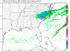
18z RGEM and 18z NAM 3k maps for you:


I have 60 percent chance of rain and snow now.
whatalife
Moderator
18z RGEM and 18z NAM 3k maps for you:
All in for my token flakes the RGEM shows me getting

Sent from my iPhone using Tapatalk
Dang GA gets screwed from round 1 AND 2. Talk about bad luck.
Kylo
Member
All models have trended better with this past few runs.18z RGEM and 18z NAM 3k maps for you:
NBAcentel
Member
freezing fog/mist now at 31°, ice accretion is still happening here, winter wonderland out there with glistening trees and snow on the ground, can wait to add more tommorow morning
For GA time of day is NOT going to be our friend
Snowflowxxl
Member
We will be paying for last December for a while.Dang GA gets screwed from round 1 AND 2. Talk about bad luck.
Hell of a lollipop in Greenville NC18z RGEM and 18z NAM 3k maps for you:
wannabwm
Member
I have a 70% chance of rain/snow showers overnight just east of Columbia, SC. Hopefully this ULL can bring me a few snowflakes.
B
Brick Tamland
Guest
Here we go again. I could see getting a couple more inches tomorrow for an encore.
pcbjr
Member
To everyone who shared insights, thoughts, PBP and pics, thanks so much for keeping all of us, particularly those of us on the outside looking in, up to date and abreast. ")
Now, here's looking forward to the same quality analysis on whatever is next (and a prayer that an old Curmudgeon might share something worthwhile in the process ... so on to that old guy starting to study teleconnections and models ...)
Now, here's looking forward to the same quality analysis on whatever is next (and a prayer that an old Curmudgeon might share something worthwhile in the process ... so on to that old guy starting to study teleconnections and models ...
)Cad Wedge NC
Member
Yep... This was a great storm. There are going to be winners and losers but all-in-all, anytime folks in the NE gets shafted and the SE gets pounded, I am happy.To everyone who shared insights, thoughts, PBP and pics, thanks so much for keeping all of us, particularly those of us on the outside looking in, up to date and abreast.
Now, here's looking forward to the same quality analysis on whatever is next (and a prayer that an old Curmudgeon might share something worthwhile in the process ... so on to that old guy starting to study teleconnections and models ...
Webberweather53
Meteorologist
Will be interesting to see how much extra snow we get tomorrow, I’m not entirely sure yet for obvious reasons but I’m somewhat confident that this winter storm may in fact be the biggest one (in terms of snow and sleet accumulations) I’ve ever seen this early in the season for the state of NC as a whole going back to 1895.
packfan98
Moderator
I can’t wait to see your map for this one. Thanks for all of your contributions!Will be interesting to see how much extra snow we get tomorrow, I’m not entirely sure yet for obvious reasons but I’m somewhat confident that this winter storm may in fact be the biggest one (in terms of snow and sleet accumulations) I’ve ever seen this early in the season for the state of NC as a whole going back to 1895.
DadOfJax
Member
So were planning to make the trip out of Maggie Valley, NC tomm. midday but I keep seeing reports of more snow headed this way this evening associated with a weak disturbance dropping through. Anybody seeing this and know a time this might be passing through?
My Carolina friends on here I have a question for you. How did cad perform on this event?? I know I saw a lot of you guys mention it. Just curious and trying to learn.
We may not get screwed so much next time.Dang GA gets screwed from round 1 AND 2. Talk about bad luck.
Jessy89
Member
It did ok I guess. I mean in liberty sc we saw 2.5-3 inches of snow/sleet. Could of been a lot more if it was colder. We hovered around 33. Saw the change over around 10pm. Hopefully we see a bigger storm in January or FebruaryMy Carolina friends on here I have a question for you. How did cad perform on this event?? I know I saw a lot of you guys mention it. Just curious and trying to learn.
ForsythSnow
Moderator
From what I could tell, the FV3 did great with track, but was too cold further south into GA and other regions. We can say that it is precise and somewhat accurate. I would give it a B for performance this time around.
The HRRR and WRF models were too cold and blasted the regions in GA too cold too early. However, they were fair for other regions. Correct me if I'm wrong, but I'll give them both a C.
The CMC was too jumpy and definitely flunked further out but I'll give it credit as I will the GFS for not being so cold, but for NC it was way too warm. Both get a C+.
The Euro was like the WRF and HRRR, too fast on the cold for GA. It otherwise was good with the track except the few wobbles but might have been too generous to some areas. B+ here.
The ICON was way too warm. F.
Lastly, the NAM seemed to perform greatly in the 3 KM runs. The mix never made it out of the mountains in GA and it was close, but maybe a bit colder for other parts further east in NC. A-.
Just my analysis from what I could tell. Feel free to correct anything I said since I might have missed something or may not have enough info.
Cad Wedge NC
Member
I agree. Going forward, we will weigh the FV3 more heavily for track and trends. As for the NAM, it has a history of being accurate with the thermals, especially within 12 hours of the event. This combo will be my "go-to" during the next winter event, once we get into the Nam's wheelhouse.From what I could tell, the FV3 did great with track, but was too cold further south into GA and other regions. We can say that it is precise and somewhat accurate. I would give it a B for performance this time around.
The HRRR and WRF models were too cold and blasted the regions in GA too cold too early. However, they were fair for other regions. Correct me if I'm wrong, but I'll give them both a C.
The CMC was too jumpy and definitely flunked further out but I'll give it credit as I will the GFS for not being so cold, but for NC it was way too warm. Both get a C+.
The Euro was like the WRF and HRRR, too fast on the cold for GA. It otherwise was good with the track except the few wobbles but might have been too generous to some areas. B+ here.
The ICON was way too warm. F.
Lastly, the NAM seemed to perform greatly in the 3 KM runs. The mix never made it out of the mountains in GA and it was close, but maybe a bit colder for other parts further east in NC. A-.
Just my analysis from what I could tell. Feel free to correct anything I said since I might have missed something or may not have enough info.
Cad Wedge NC
Member
I'd say so. It now has much more QPF. This one is going to surprise somebody.... in a good way.Most recent HRRR more aggressive with snow in the Carolinas tomorrow with the upper low
NBAcentel
Member
I sit pretty with this ULL, somebody could get 3-4 inches if it snows on you for 5+ hours like the hrrr Is showing
Tomorrow could be as fun as today, unpredictable, more dynamic maybe convective... seriously someone could score tomorrow.
Sent from my SM-G950U using Tapatalk
Sent from my SM-G950U using Tapatalk
Kylo
Member
18z Euro. Stuff south of I-40 is all tomorrow stuff obviously.

The 12z Euro run had it too.

The 12z Euro run had it too.
Kylo
Member
Tomorrow could be as fun as today, unpredictable, more dynamic maybe convective... seriously someone could score tomorrow.
Sent from my SM-G950U using Tapatalk
I looked at the models yesterday about this and they weren't enthused, haven't looked today until the 18z runs. Be nice to see flakes fly two days in a row.
NBAcentel
Member
Yeah, I think a convective snow burst would be nice, Is thundersnow in the question or will the ull be to weak for that
These winds today have been relentless, frequent gust up to 30 mph... so thankful no zr with this
Sent from my SM-G950U using Tapatalk
Sent from my SM-G950U using Tapatalk
Top report I saw was 24” in south-west Virginia. I think I did really well my forecast minus a few areas in the GSP area did better than I thought and I certainly missed the forecast for Brick in Raleigh.
NBAcentel
Member
It also continues to trend NW with the R/S line so you know its legitIt continues to trend more amped, lol looks like another winter storm
Sent from my SM-G955U using Tapatalk
I'm in the same boat as Rain Cold and SD here with my one inch of frozen slop. LOL at some folks saying the FV3 is awesome. Let's see, it forecast a 6-7 inch snowfall for MBY. The HRRR and RAP did just as bad as they forecast 6+ inches as the storm was beginning. The 3K NAM even gave me 4+ inches. The only models that even came close to getting it right were the RGEM and GGEM as they both forecast less than an inch. Those will be the models that I will be watching for MBY from now on.
Last edited:
Surprise! More rain @ GSPI'd say so. It now has much more QPF. This one is going to surprise somebody.... in a good way.
I thought most models did well. A lot showin 32-35 In GSP proper, and a lot of people were saying that was gonna be too warm, but not really, I never got below 33 and had a “ great” accumulation of sleet for those temps and 10 hours of rain before hand!My Carolina friends on here I have a question for you. How did cad perform on this event?? I know I saw a lot of you guys mention it. Just curious and trying to learn.
NBAcentel
Member
Another nowcasting situation, watch for blossoming precip along the mountains, foothills, eastern tennessee and northern Georgia
Kylo
Member
What the heck NAM?


Kylo
Member
Alright, this is getting nuts on the NAM. LOL.

From what I could tell, the FV3 did great with track, but was too cold further south into GA and other regions. We can say that it is precise and somewhat accurate. I would give it a B for performance this time around.
The HRRR and WRF models were too cold and blasted the regions in GA too cold too early. However, they were fair for other regions. Correct me if I'm wrong, but I'll give them both a C.
The CMC was too jumpy and definitely flunked further out but I'll give it credit as I will the GFS for not being so cold, but for NC it was way too warm. Both get a C+.
The Euro was like the WRF and HRRR, too fast on the cold for GA. It otherwise was good with the track except the few wobbles but might have been too generous to some areas. B+ here.
The ICON was way too warm. F.
Lastly, the NAM seemed to perform greatly in the 3 KM runs. The mix never made it out of the mountains in GA and it was close, but maybe a bit colder for other parts further east in NC. A-.
Just my analysis from what I could tell. Feel free to correct anything I said since I might have missed something or may not have enough info.
I drove back from Asheville this morning and there was snow patches all the way down to mile marker 154 into Georgia on I-85, just a dusting, but still at low elevation. Our local channels refer to that entire region as the "northeast Georgia mountains." Cobb and Forsyth county have more mountains than any county I-85 comes close to. As a matter of fact, you don't even exceed 1500' until you reach Rabun County from that side. This storm was very CAD based, and it was interesting to see how many much higher elevations west of Towns County and the southwestern mountains of North Carolina completely left out.