Avalanche
Member
Wow 20" in Chatham. If only it could be all snow.
It definitely shifted south we want the low to continue to shift.
If it’s mostly snow I say bring it onUpstate got wrecked on that run of the FV3. I’m not so sure I want any part of that
I believe.

North of 85 should be sitting pretty. I feel like the sleet/snow transition line would be a little further south of 85 if the storm were to happen today. After today’s model guidance I would say I’d be riding that transition line with a raging sleet storm with the rain/sleet line well to my south towards Greenwood/Newberry. Just my take. I’ve been burned beforeIf it’s mostly snow I say bring it on
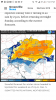
thats still a nice little snow for ATL. I dont think many would complain about 1-3". And 6 inches in Chatt !Here’s a better FV3 map that filters out the ice. Still a huge hit.
View attachment 8540

North of 85 should be sitting pretty. I feel like the sleet/snow transition line would be a little further south of 85 if the storm were to happen today. After today’s model guidance I would say I’d be riding that transition line with a raging sleet storm with the rain/sleet line well to my south towards Greenwood/Newberry. Just my take. I’ve been burned before
On the "other" board they are saying this is not the correct picture, real one says much much different, 1" in GSP. I don't live down there so I don't know


In regards to the FV3 on weather nerds.. for some reason even down here it starts as snow, goes over the mix, then to sleet, then back to mix, and then goes back to snow to end.On the "other" board they are saying this is not the correct picture, real one says much much different, 1" in GSP. I don't live down there so I don't know
Basically the ne upstate will see more then the nw upstateThis is from gsp, real news, I've never seen them so bullish this early
Im already planning on driving the family up to TR and eating/drinking a couple beers at Willy Taco on the way. It’s a short trip to witness the goodsYeah I live in Pickens County. Close to airport. So hoping for the best either it snows here or Sunday I’ll take my little boys to play in the snow in Hendersonville. But if we can get a few inches I won’t have to leave the house
Or eastCareful in the Southern Zones with those FV3 maps. They are likely not right so far South.
Sleetfest it is with some ice as well. That'll take forever to melt if we get sleet and ZR mix and it accumulates rapidly to a several inch block.I see you FV3 lol. Here pivotal's ice accumulations.
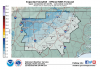
Soundings have wintry mix sleet/zr Sunday afternoon/evening then transition to snow Monday.View attachment 8541 View attachment 8543 View attachment 8545
College dupage does https://weather.cod.edu/forecast/In regards to the FV3 on weather nerds.. for some reason even down here it starts as snow, goes over the mix, then to sleet, then back to mix, and then goes back to snow to end.
Does anyone have a source for soundings on the FV3 other than Weathernerds?
Don’t worry, it’s only 3” of sleetUpstate got wrecked on that run of the FV3. I’m not so sure I want any part of that
Don’t worry, it’s only 3” of sleet
.png")

NWS RAH very bearish. Current forecast is for <1" in Raleigh
Upstate got wrecked on that run of the FV3. I’m not so sure I want any part of that
I like the EuroWhen one you like? 18z Euro v/s GFS. GFS a little quicker bringing in precip which is big difference for us central NC folks.
View attachment 8548 View attachment 8549
Marginal surface temps too last year. 8" in chatham with 33deg throughout the event.Someone correct me if i'm wrong but the evolution of the ULL on the FV3 reminds me alot of the January 17th storm last year for NC