Euro is now seeing the cold air with CAD being stronger than previous runs.That looks like the higher totals actually spread farther east in NC.
-
Hello, please take a minute to check out our awesome content, contributed by the wonderful members of our community. We hope you'll add your own thoughts and opinions by making a free account!
You are using an out of date browser. It may not display this or other websites correctly.
You should upgrade or use an alternative browser.
You should upgrade or use an alternative browser.
Wintry Dec 8-10th Winter Storm
- Thread starter SimeonNC
- Start date
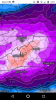
Heck yeah! Slid east just a touch.... shoot it ain't 30" but I'd be happier than a hog eatin' slop to get 3". Hope you guys get crushed, there's a metwannabe special lurking out there later this winterThis is nearly a 4 day event, here comes the upper wave and it's still snowing on early Tuesday for much of NC.
View attachment 8276
Clown map... cut this in at least 65-75% SE of the triad, but it's still awesome.
View attachment 8277
Avalanche
Member
Yeah I saw Chatham with 8 and Wake with 4-6. Go to Guilford......a foot!!!! Just an hour drive.Looks like just a few miles separate 3 to 6 inches and then 6 to 12 inches for the Triangle.
Avalanche
Member
Met you're really not far. Person county (as always) loaded up. They are only roughly and hour or so from you right?Heck yeah! Slid east just a touch.... shoot it ain't 30" but I'd be happier than a hog eatin' slop to get 3". Hope you guys get crushed, there's a metwannabe special lurking out there later this winter
If thats the snowfall map, how could we see the Ice and Sleet which should be even further south right???This is nearly a 4 day event, here comes the upper wave and it's still snowing on early Tuesday for much of NC.
View attachment 8276
Clown map... cut this in at least 65-75% SE of the triad, but it's still awesome.
View attachment 8277
B
Brick Tamland
Guest
Looks like a better run overall, with more snow falling farther east in NC.
That's about right but let's face it in the Winter, Person County might as well be a day away Lol.... but tbh it's good trends and looking like a major winter storm for a good number on here, what a heckuva way to kick off this WinterMet you're really not far. Person county (as always) loaded up. They are only roughly and hour or so from you right?
Euro is ok
Sent from my SM-G955U using Tapatalk
Sent from my SM-G955U using Tapatalk
B
Brick Tamland
Guest
This is starting to remind me of the Christmas 2010 snow storm.
Brandon10
Member
I wish. That one had snow all the way to the coastline.This is starting to remind me of the Christmas 2010 snow storm.
snowlover91
Member
Solid trends today with the models. The key component that could really help (or hurt) folks out in Central NC hoping to see some snow is the late phasing shown by the Euro and UK models. This changes the rain back to snow and gives a few inches to areas like Wake County. However, the negative of this is if the phasing ends up quicker this will cut and then even Western NC will see the heavy snowfall zone narrow. A very complex setup that we probably won't have a good handle on until Thursday afternoon at the earliest.
whatalife
Moderator
It’s going to be nice when this wave is sampled. I cannot imagine this southward trend continuing much longer.
Sent from my iPhone using Tapatalk
Sent from my iPhone using Tapatalk
B
Brick Tamland
Guest

Webberweather53
Meteorologist
It’s going to be nice when this wave is sampled. I cannot imagine this southward trend continuing much longer.
Sent from my iPhone using Tapatalk
Definitely worried a threat for ZR could sneak up on you and the Atlanta folks at the last second if this CAD high is really as strong as modeled.
TerryInTucker
Member
Just a little further south and west, please.Where are my Georgia friends? This map gives us hope, love the trends today.
")
Avalanche
Member
Yeah this latest run probably depicted the best possible scenario for central NC. Margin of error much safer for western Triad on further.Solid trends today with the models. The key component that could really help (or hurt) folks out in Central NC hoping to see some snow is the late phasing shown by the Euro and UK models. This changes the rain back to snow and gives a few inches to areas like Wake County. However, the negative of this is if the phasing ends up quicker this will cut and then even Western NC will see the heavy snowfall zone narrow. A very complex setup that we probably won't have a good handle on until Thursday afternoon at the earliest.
Definitely worried a threat for ZR could sneak up on you and the Atlanta folks at the last second if this CAD high is really as strong as modeled.
I have no knowledge, just experience, but this is exactly how things have played out in the past.
@WXinCanton Ellijay is right on the gradient according to the EURO clown ,map. Showing 4" here, 15" only 15 miles to my east and nothing 15 miles to my west. Getting closer today though!
Everyone in SW of Carolinas are pulling for one of 2 things...Just a little further south and west, please.
1. Colder 850 and surfact temps then modeled by 2-3 degrees and timing
or
2. A true ULL developing on the southern end of that storm
Plenty of time on the clock to see where it goes
snowlover91
Member
Yeah this latest run probably depicted the best possible scenario for central NC. Margin of error much safer for western Triad on further.
Best scenario would be this Euro track but no or even later phasing for Central and Eastern NC. Usually in phasing setups though they often phase a bit quicker than modeled so this phasing being modeled by the UK and Euro is concerning IMO. The 850s start out colder but would quickly change most folks to rain or ice depending on actual surface temps if we see quicker phasing. A fine line we are walking here. Western NC looks like the place to be for a few feet of snow.
whatalife
Moderator
Definitely worried a threat for ZR could sneak up on you and the Atlanta folks at the last second if this CAD high is really as strong as modeled.
Yep that’s my main concern right now.
Sent from my iPhone using Tapatalk
packfan98
Moderator
Here's the reason the Euro warms things up at the 850 level. It has a very weak/diffuse 850 low up in Tennessee that is in the process of transferring to SC and off the NC coast. In the process of this the TN 850 low is bringing in E to ESE winds which warms things up.
You can see it here on this map as well with the warm air advection pushing well inland. This detail is something the globals may not be able to properly resolve this far out and we may need to wait for the NAM/RGEM to figure out how this will unfold with any LP transfer.
The Euro would be the best of the globals to seek out these features because of it's higher resolution. It will be good to get the other Hi-Res models take on it starting tomorrow and Thursday.
Avalanche
Member
Randolph Co has look good on several suites now.The Euro would be the best of the globals to seek out these features because of it's higher resolution. It will be good to get the other Hi-Res models take on it starting tomorrow and Thursday.
Kylo
Member
Interesting precip min for central NC. Although 1-1.5" qpf is no slouch.

snowlover91
Member
The Euro would be the best of the globals to seek out these features because of it's higher resolution. It will be good to get the other Hi-Res models take on it starting tomorrow and Thursday.
I agree, the Euro should pick up on it. I'm curious what the mesoscale models will show when in range, usually in complex setups like this they can be quite different.
EastAtlwx
Meteorologist
This is probably a stupid question but does anyone have experience with how well treated roads will be and if I have4 wheel drive will i be able to get back for my exam 7-10 pm on Monday night?
Unless cold push/confluence, is well underestimated!?It’s going to be nice when this wave is sampled. I cannot imagine this southward trend continuing much longer.
Sent from my iPhone using Tapatalk
Webberweather53
Meteorologist
Lol you know it's a good storm when you get shafted and still have almost 1.5" QPF
SnowNiner
Member
Uh, hello?! Could someone throw me down a rope please? I'd like to climb back up the cliff now....I jumped too soon. Hello? lol.
Wow, just catching up on great trends overnight and this afternoon. While the operational models are nice to look at, I'm more interested at this point just making sure the ensembles keep the track along the florida panhandle and off the coast. This FV3 inland running non-sense has to stay away.
Excellent to see both the Ukmet and Euro now agreeing on the overall parameters of a southern NC piedmont snowstorm. Those 2 are my jam.
WXinCanton
Member
@WXinCanton Ellijay is right on the gradient according to the EURO clown ,map. Showing 4" here, 15" only 15 miles to my east and nothing 15 miles to my west. Getting closer today though!
I will chase if it's that close!!! Just have to procure a 4WD vehicle to use. Though my Fusion can hold its own fairly well. Honestly if the CAD over performs I could see a major IP event or ZR in our neck of the woods. I'm down with that, lol.
Rosie
Member
No freezing rain, forest close to my house.I will chase if it's that close!!! Just have to procure a 4WD vehicle to use. Though my Fusion can hold its own fairly well. Honestly if the CAD over performs I could see a major IP event or ZR in our neck of the woods. I'm down with that, lol.
Kylo
Member
I will say the 850 low tracked south of us so I'm holding out hope that temps will be colder.... but overall that's too amped, too close to the coast for us
Yeah, I thought we would have been better off with this 850mb low track...over MYR. Borderline temps will always rule I guess.

Sandstorm94
Member
Snowflowxxl
Member
sheeeeeeeshEuro Master... Jesh
FFC:
.LONG TERM /Thursday through Tuesday/...
Medium-range models continue to point toward at least a chance for a
wintry mix of precipitation across portions of the forecast area
this weekend into early next week. Run-to-run variations continue
concerning the path of the surface low, but GFS and ECMWF are now
generally a bit closer to each other, bringing the low across far
south Georgia. Best chances for wintry precipitation remain confined
to the far northeast at this time, but will need to be watched
closely for any trends toward a cooler solution. Both the GFS and
ECMWF have backed off some on the wrap around precipitation
potential Sunday night through Monday, keeping the system a bit more
progressive and not anchoring a surface low along the Carolina coast
for an inordinate amount of time. All-in-all, I made minimal changes
to the extended forecast grids with this cycle.
packfan98
Moderator
12z NavGem has a track similar to Euro. Just a bit further off shore to help those on the eastern side.
Yellow Snow
Member
If you're talking about GA roads, supposedly the state DOT has new & improved brine treatment...This is probably a stupid question but does anyone have experience with how well treated roads will be and if I have4 wheel drive will i be able to get back for my exam 7-10 pm on Monday night?
Jrips2710
Member
12z Euro 3 hour precip type GIF courtesy of Ryan Maue on twitter
Woah.Euro Master... Jesh