I know all of our winter events come down to the wire, but this one is going to be super tough because of the complex situation. Notice how every model has something different every solution? Euro trended south in some key areas imho
-
Hello, please take a minute to check out our awesome content, contributed by the wonderful members of our community. We hope you'll add your own thoughts and opinions by making a free account!
You are using an out of date browser. It may not display this or other websites correctly.
You should upgrade or use an alternative browser.
You should upgrade or use an alternative browser.
Wintry Dec 8-10th Winter Storm
- Thread starter SimeonNC
- Start date
Did euro have the backend show (ULL)I know all of our winter events come down to the wire, but this one is going to be super tough because of the complex situation. Notice how every model has something different every solution? Euro trended south in some key areas imho
Webberweather53
Meteorologist
Still snowing at 180 hr in much of NC, this is insane lol.
Not sure yet.Did euro have the backend show (ULL)
NBAcentel
Member
Wow is all I gotta say
NBAcentel
Member
Everybody was beggining to write this thing off to
Sandstorm94
Member
That's better for me0z Navgem also shifted south into north central Florida with track Wow.
12-18 “ on a clown map I saw! We tossI heard the upstate got raked

 Look at your own risk....
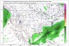
Lol. South of Charlotte goes from 18 to nothing in like 20 miles.View attachment 8220 View attachment 8221 Look at your own risk....
Must be a rain accumulation map. Remember the rule: If you can smell it he rain, it’s rainingView attachment 8220 View attachment 8221 Look at your own risk....
It can’t be fun being on the S edge of all these good model runs! I don’t like where we sit until those snow lines shift another 50 miles S! Doable in 4 days!Must be a rain accumulation map. Remember the rule: If you can smell it he rain, it’s raining
accu35
Member
So i take it, no back end snow? I'm at work
Ilovesnow28
Member
Still no improvements for Alabama and Mississippi
Is that just snow accumulations? Do the Euro have one for Ice.View attachment 8220 View attachment 8221 Look at your own risk....
accu35
Member
Thanks, I know the Icon/GFS and gefs had a thump up on the members with wrap around.Still no improvements for Alabama and Mississippi
About that NAVGEM model from 00z with the very far Southern track.
There's no cold for SC to be found. 2m & 850s are warm.
It does have the upper level low crossing, which could theoretically drop snow anyways behind, though.
There's no cold for SC to be found. 2m & 850s are warm.
It does have the upper level low crossing, which could theoretically drop snow anyways behind, though.
The Navgem is always always warm this far out it will definitely get colder as we get closer. Honestly the last couple of storms I remembered Navgem was close to spot on with track.About that NAVGEM model from 00z with the very far Southern track.
There's no cold for SC to be found. 2m & 850s are warm.
It does have the upper level low crossing, which could theoretically drop snow anyways behind, though.
So for my GA peeps this actually isn't as far off as it appears. 2m temps from 3PM SAT to 4PM SUN temps are around the mid 30's from ATL and N and near 40ish for Mid GA....here is the bad news though.....850's are like 1-3c from 3pm to like 9pm ish, then spike to around 5-7c for the north and like near 10c for mid ga (mid ga starts around 3-5c). they fall to near 0c by midnight Sunday near NGA and then by 4am or so around mid GA. problem is....no moisture by the time that happens though.
Points being, that the doc has been getting progressively colder, from what I can tell at 2m and 850 on each run. Sunday morning temps are nearly 5-8 degrees colder around here, and a good 4-6 degrees colder up in NGA.
Time will tell, but trends still are not total 0 for wintry across our state. lets see if the doc will continue to cool.
1 more point about GFS vs EURO tonight....EURO is actually colder at 2m and 850 (in most cases) at all the time stamps that I checked.
Snowluvr
Member
Thank you for the detailed explanation! I hope we can at the very least see some flurries! I guess we wait and see!So for my GA peeps this actually isn't as far off as it appears. 2m temps from 3PM SAT to 4PM SUN temps are around the mid 30's from ATL and N and near 40ish for Mid GA....here is the bad news though.....850's are like 1-3c from 3pm to like 9pm ish, then spike to around 5-7c for the north and like near 10c for mid ga (mid ga starts around 3-5c). they fall to near 0c by midnight Sunday near NGA and then by 4am or so around mid GA. problem is....no moisture by the time that happens though.
Points being, that the doc has been getting progressively colder, from what I can tell at 2m and 850 on each run. Sunday morning temps are nearly 5-8 degrees colder around here, and a good 4-6 degrees colder up in NGA.
Time will tell, but trends still are not total 0 for wintry across our state. lets see if the doc will continue to cool.
accu35
Member
I'm on lunch so I can post. FWIW, 6z Nam is pretty far south hour 75
Clem282340
Member
6z nam is pretty far south and looks to have a 1041 high
Forevertothee
Member
NWS GSP
LONG TERM /FRIDAY THROUGH MONDAY/...
As of 340 AM Tuesday: Confidence continues to grow that a
significant winter storm will impact portions of the forecast area
beginning sometime Saturday and continuing in earnest Sunday and
possibly evening Monday. However, the details this far out are still
sketchy at best as any small changes in the track or strength of the
storm system or parent sfc high pressure to the north could make the
different be mostly a cold rain or significant ice/snow. The
greatest confidence in significant ice/snow accumulations continues
to be across the mountains and east facing foothills where WPC
continues to advertise a 50-70 percent chance of winter storm
warning level ice/snow accumulations. The latest forecast blends the
EC and GFS, leaning towards the slower EC in line with neighboring
offices and WPC. Now for the forecast details as they stand now.
Zonal flow will continue into the extended time frame Friday with
surface high pressure continue to exert its influence across the
region into Saturday. The net result will be fair skies with
reinforcing cool and dry air Friday night as air damming or a wedge
sets up east of the mountains Friday night, which will likely
persist through the weekend. This will set the stage for the
potentially significant winter storm as wet bulb temperatures fall
into the mid 20s to mid 30s across the FA Saturday. An amplified
upper trough will push through the southern Plains states into the
Deep South Friday into Saturday with an attendant sfc low pressure
system riding the Gulf of Mexico coastline before moving off the
Southeast coastline Sunday. The CAD and increasing clouds and precip
Saturday into Sunday will lock in cold temps with lows only in the
20s to 30s and highs only in the 30s to low 40s this weekend. This
scenario looks to favor mostly wintry precipitation and possibly
mostly snow across the mountains with a mix bag of precipitation
across the NC Piedmont with some combination of rain or mixed
precipitation further south into the Upstate of SC and northeast GA.
While its too early to get into precipitation type details, wouldn`t
be surprised to see more wintry look to precip across the region
near onset and towards the end with more rain or ice in between when
the storm is closest and pushes warmer air at mid levels (aka warm
nose) into the region. The heaviest precip currently looks to take
place Saturday night into Sunday. In addition to the wintry this
weekend, model guidance shows some potential for significant snow on
the backside of the storm late Sunday into Monday. Now is the time
to put your winter weather plan together to be prepared for this and
future potential winter storms.
Sent from my iPhone using Tapatalk
Last edited:
06Z GFS significantly further S compaired to 00Z.
Edit: Ends up about the same place though at hour 120. By hour 150 the low ends up further North over the NC sounds just West of Hatteras. compaired to off the coast East of the NC/SC border a lot more rain then snow for a lot of people.
Edit: Ends up about the same place though at hour 120. By hour 150 the low ends up further North over the NC sounds just West of Hatteras. compaired to off the coast East of the NC/SC border a lot more rain then snow for a lot of people.
Last edited:
Last 5 runs of the GFS including current for the same time-frame:
.gif")
Going to take a huge change to keep the WAA away from the majority of SC. Like hundreds of miles or something South.
Going to take a huge change to keep the WAA away from the majority of SC. Like hundreds of miles or something South.
Last edited:
packfan98
Moderator
Notice the HP is getting stronger. Look for the surface temps to trend down on subsequent runs extending the impact of significant icing.Last 5 runs of the GFS including current for the same time-frame:
View attachment 8222
Going to take a huge change to keep the WAA away from the majority of SC.
Here's the best looking sounding during the main event I can find for CLT:

I know it's long range nam, but 850h temps are noticable colder over the region than GFS same time stamp. The nam is 0-1c over majority of N GA compared to 3-5c on GFS. Dont know if makes much of a difference right now since end of the run.


BHS1975
Member
Yeah gfs too warm. The ICON is slightly cooler.
Sent from my iPhone using Tapatalk
Sent from my iPhone using Tapatalk
Fountainguy97
Member
Gfs, fv3, cmc, euro, all show the traditional CAD setup. Nothing “super” at all and in fact even CAD regions go dangerously close to plain rain.
Looks like most areas outside of that CAD region are now mostly out of the game for this one.
Looks like most areas outside of that CAD region are now mostly out of the game for this one.
ForsythSnow
Moderator
Overnight overall looks better despite the GEFS dropping most of the snow it had for N GA. Colder and further south we go again it looks. I knew the early NW trend was fishy.
DPs are better overall as well (specifically across the Carolinas/TN/Far N. GA). If the NAM was extrapolated, it looks like DPs continue to fall from north/south. I'm curious to see how this evolves over the next 48hrs, hopefully for the better than worse.


EDIT: I also checked 2m temps between these two models and the NAM (again, albeit Long Range) is significantly colder at 18z FRI vs the GFS. For example for my area, it's 54°F on the GFS, but on the NAM it's 47°. It's mostly in the 30s and 40s across TN/N. GA/Carolinas on the NAM vs. 40s to 50s in the same region, so you're talking about as much as 5-10 degrees difference.
EDIT: I also checked 2m temps between these two models and the NAM (again, albeit Long Range) is significantly colder at 18z FRI vs the GFS. For example for my area, it's 54°F on the GFS, but on the NAM it's 47°. It's mostly in the 30s and 40s across TN/N. GA/Carolinas on the NAM vs. 40s to 50s in the same region, so you're talking about as much as 5-10 degrees difference.
Last edited:
No backend snow (ULL)DPs are better overall as well (specifically across the Carolinas/TN/Far N. GA). If the NAM was extrapolated, it looks like DPs continue to fall from north/south. I'm curious to see how this evolves over the next 48hrs, hopefully for the better than worse.
I know it's long range nam, but 850h temps are noticable colder over the region than GFS same time stamp. The nam is 0-1c over majority of N GA compared to 3-5c on GFS. Dont know if makes much of a difference right now since end of the run.View attachment 8227 View attachment 8228
No backend snow (ULL)
This is 18z Friday (Friday afternoon) so our main storm hasn't even moved in yet.
ForsythSnow
Moderator
The 6Z FV3 is back colder with the CAD into NE GA again. Looks way better than 0Z did.