• Hello, please take a minute to check out our awesome content, contributed by the wonderful members of our community. We hope you'll add your own thoughts and opinions by making a free account!

Wintry Dec 8-10th Winter Storm

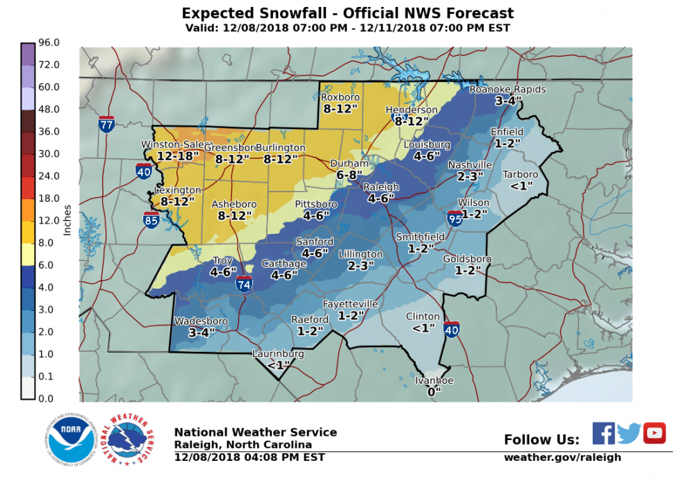
RAH has me right on the 4 to 8 line.

Only a slight change in forecast snow amounts with the heavy wet snowfall axis of 8 to 12 inches expected to along and north of I-85, with the predominate p-type expected to fall as mainly, with diabatic and strong dynamic lift/cooling supporting a deep near
freezing isothermal layer. Lift and saturation will begin to wane 21 to 00z, with p-type changing over to a light freezing rain/drizzle
overnight. Ice amounts are expected to be less than a 0.10".

Just south of this heavy snow area and west of US 1, snow amounts of 4 to 8 inches are possible, with the bulk of the snow occurring
through mid to late morning. Then as the warm air aloft spreads into the area from the southeast, p-type is expected to change-over to freezing rain, with a 0.10 to 0.25" of freezing rain/ice possible through the afternoon.
If the change-over to freezing rain occurs quicker than forecast, snow amounts will be less, but ice amounts could easily exceed a
0.25" of an ice. Ice/freezing rain amounts combined with wind gusts in the 25 to 35 mph range will cause widespread damage from downed trees and power-lines.

Finally, east of US-1 and south of I-85, warm nose spreading into the area during the mid to late morning will result in a sharp NW to
SE reduction in snow and ice amounts. After a quick morning burst of snow and/or snow-sleet mix, which could bring 1 to 4 inches of
snow to the area, a brief period of freezing rain can be expected before changing over to rain. Little to no ice is expected.

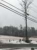
Surprised they are upping the triangle. When was the last time with marginal temps we overperformed or even met expectations.
 
Jimmy, why do we always fall for this crap! Cold rain special coming, it’s a mind numbing 39.4 degrees now! Just screams record setting snow and sleet storm! :(
Well we’ve got 13 hours for it to drop to 32. Nothing shows us getting any frozen til around 5am anyway. I’m right there with you though. I’ve told family 1” sleet/tree glaze. When we start as rain, it usually rains. The potential is still there though. We are sitting on a fine line. Plus my mom just said she saw some snow mixing in Simpsonville. Confirm?
 
Well we’ve got 13 hours for it to drop to 32. Nothing shows us getting any frozen til around 5am anyway. I’m right there with you though. I’ve told family 1” sleet/tree glaze. When we start as rain, it usually rains. The potential is still there though. We are sitting on a fine line. Plus my mom just said she saw some snow mixing in Simpsonville. Confirm?
the hourly grids on the NWS website shows you getting 3-4" of snow between Midnight and 4am.
 
Great weather posts, y'all. Be safe and keep them coming!
Just a steady rain and 41 with my weather station here. Y'all remember to have everything charged before tomorrow. Could be interesting times!
Take care all!
We have 39 over here on the west side of Athens - if I get snow first, I'll try to send some your way!

Speaking of Athens, KAHN measured a wind gust of 22 mph a little while ago. It seems like the wind aspect of this storm hasn't been discussed much, although Peachtree City touched on it in their afternoon briefing today.
Screenshot-2018-12-08-at-4-57-02-PM.png
 
As far as ZR/IP line, maybe a bit west/south of that/.. Canton/Stone Mountain/Conyers/Madison/Washington line.. I m basing on where precip increased all day long, so something is forcing right through there.
Sounds plausible. I just want this to be an over-performer for areas that normally get at least something from wedges. We're so close, especially my area. I'm right on the line.
 
Sounds plausible. I just want this to be an over-performer for areas that normally get at least something from wedges. We're so close, especially my area. I'm right on the line.
We are actually much further away. In dawsonville right now and still all rain. Line is further up in the mountains still.
 
We are actually much further away. In dawsonville right now and still all rain. Line is further up in the mountains still.
What I meant is that we're gonna be so close in the morning to getting something and getting nothing. Forsyth likely will be the county that has a big gradient between nothing and at least some pretty glazing. As long as we keep the precip moving NE into the carolinas, that will lock our CAD in and send it oozing our way. Temp here keeps inching down, now 37.8.
 
New map from NWS, W-S west is going to get buried if this is right (No I do not think it is plausible)

rah.thumb.png.147b36b040a61264fdf8df5b00779636.png
 
Left liberty sc to take a drive with the kids. Cashiers and Glenville is dangerous we slid all over the place. Now in Sylva nc it’s a rain snow sleet mix and 37 degrees. If Sylvia is that warm with nothing on ground. No way we see 2-4 inches back home in liberty Greenville and places. On a brighter side my kids got to play in the snow. So if we see nothing I’m happy because they got to play just a few pictures I took
 

Attachments

  • 3AEA24B1-1A22-4143-B150-7CE49FA203AF.jpeg
    3AEA24B1-1A22-4143-B150-7CE49FA203AF.jpeg
    1.9 MB · Views: 59
  • CE83A16B-BB9E-4E48-B484-F4D4D2CE6210.jpeg
    CE83A16B-BB9E-4E48-B484-F4D4D2CE6210.jpeg
    199.8 KB · Views: 62
Really hoping rates pick up here in Maggie Valley.....no way we get close to verifying to double digits at this rate. Its been fun no doubt, but NOTHING like what was predicted.
 
That’s shameful. There’s no way it will be all rain! I’m 99% sure we mix a pinger in there every now and then
I think we are safe from power outages! Don’t think we are going to lose power and get accretion at 35 degrees! We should be under a flood advisory, not WSW! :(
 
Never made it above 41 today. Creeping back down to 39.2, but no clear wind shift. Still variable out of the E & SE. Seldom switch to ENE & NE, but nothing too sustained. I think I’m going to be just a smidge too far to the south& west.


Sent from my iPad using Tapatalk
 
Never made it above 41 today. Creeping back down to 39.2, but no clear wind shift. Still variable out of the E & SE. Seldom switch to ENE & NE, but nothing too sustained. I think I’m going to be just a smidge too far to the south& west.


Sent from my iPad using Tapatalk
Interesting. I've had a steady E to ENE wind for the last several hours.. several gusts to 20-25 last hour as well and seems to be increasing. Finally down to 38.6 after sitting at 40 much of the day.
 
Where do you imagine we are time wise with this? I guess I mean, which model seems to be matching best with where we are wedge wise so far?
Latest HRRR seems to bring the sleet in here about 5 or 6 hours from now, so close to midnight. The rates then could really pile the sleet up or it could mostly melt in due to the rain. That is unless we go below freezing and get a block of ice in the ground.
 
Interesting. I've had a steady E to ENE wind for the last several hours.. several gusts to 20-25 last hour as well and seems to be increasing. Finally down to 38.6 after sitting at 40 much of the day.
Same here, I had a high gust of 20mph so far at 3:30pm but my anemometer isn't high enough, but it's been E/NE all day. 37.2 now. Creeping down every so slightly.
 
Interesting. I've had a steady E to ENE wind for the last several hours.. several gusts to 20-25 last hour as well and seems to be increasing. Finally down to 38.6 after sitting at 40 much of the day.

You’re ever so slightly north of me, but a solid 20 miles to the west according to your profile


Sent from my iPad using Tapatalk
 
Latest HRRR seems to bring the sleet in here about 5 or 6 hours from now, so close to midnight. The rates then could really pile the sleet up or it could mostly melt in due to the rain. That is unless we go below freezing and get a block of ice in the ground.
Honestly, I really don't want sleet because as wet as the ground is, especially with marginal temps, the sleet would likely melt. I want zr just to see a nice coating in the trees.
 
Latest HRRR seems to bring the sleet in here about 5 or 6 hours from now, so close to midnight. The rates then could really pile the sleet up or it could mostly melt in due to the rain. That is unless we go below freezing and get a block of ice in the ground.
hard for the sleet to freeze to the ground when its landing on puddles !
 
Would this be more of a snow sounding due to heavy rates ?
 

Attachments

  • Screenshot_20181208-180612.png
    Screenshot_20181208-180612.png
    406.9 KB · Views: 40
I feel so stupid for freaking out about surface temps now lol

lol It's understandable, I kinda felt that way in the December 2017 storm, nervously and anxiously waiting for that temperature drop and changeover to happen. It was well worth the wait to get that 5 inches of snow on the backend.
 
Probably not accumulate on the roadways so much. I was mainly thinking just wet surfaces and not ditches or large puddles. We aren't in a lake.
I would think that unless rates are extremely heavy, you are going to have to get well below freezing to have major sleet accumulations.
 
Major ZR/IP/SN >2" ATL (since 1940 for ZR; since 1952 for SN and IP): 41 total


Resultant winds during precip.:


Avg Direction # storms

E 23 (most of these mainly ZR or IP)

NE 8 (all mainly SN)

N 3 (all mainly SN)

NW 6 (all mainly SN

W 1 (mainly SN)

- All 18 ZR's and 3 IP's had E winds. That is consistent with E winds generally being associated with efficient wintry precip. producers at ATL.
 
Back
Top