EastAtlwx
Meteorologist
In highlands for a bit then headed up to cashiersYou’re seeing a R/S mix in Conyers?
Sent from my iPad using Tapatalk
In highlands for a bit then headed up to cashiersYou’re seeing a R/S mix in Conyers?
Sent from my iPad using Tapatalk
And yet for some reason the NWS only forecast 41 in Charlotte. Why? Its up to 46 in Charlotte now. A whopping 5 degrees warmer than forecast with about 2 hours of heating left in the day.these temps in the mid 40s were always well predicted by models. HRRR clearly has many areas in the 43-45 range. Temps dive tonight with arrival of heavy precip. That was always the forecast
In highlands for a bit then headed up to cashiers
I’m pretty close to downtown Greenville and I am sitting at 39, and dropping.I’m south of 85 in the upstate and my temp is 5 degrees cooler than Charlotte atm
we in for a surprise?For NE GA, the 0c line should be past that area by 13z up at 850mb. The 0c line is already slightly past Rabun county in GA.
What’s your thoughts on ice??For NE GA, the 0c line should be past that area by 13z up at 850mb. The 0c line is already slightly past Rabun county in GA.
Good deal. Keep us updated. We are in the Golden Strip areaI’m pretty close to downtown Greenville and I am sitting at 39, and dropping.
We could, we have to keep watching radar trends and those temps.we in for a surprise?

I’m curious about this as well....What’s your thoughts on ice??

Fv3! Fv3!Latest FV3
")
We could, we have to keep watching radar trends and those temps.
How far southwest will the 850mb move?For NE GA, the 0c line should be past that area by 13z up at 850mb. The 0c line is already slightly past Rabun county in GA.
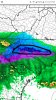
PicturesFv3 upped ice totals for ne ga
Pivotalweather.comPictures
We won't really know, determining how far southwest that 0c up at 850mb can be very difficult.How far southwest will the 850mb move?
Thanks! This thread will top that, and easily for one event. All the best!The 2018 banter thread.
Banks county is in FFc.Why is Hart and Franklin Co GA in advisory when other counties on each side in warnings? I dont get it..
Of course, but a good cad would leave some low level cold in place, and more easily reinforced when the ull brings it's own cold byWell if GA gets backside snow, it won't be from the CAD, but from the CAA from the northwest as the upper level trough swings through.
A weak cad all erodes out, and makes the ull have to work all the harder, leaving a lot us of outside looking in.Some of that yellow is prob sleet mixing in at times.The supercooling is happening in NE GA. I see some spots of sleet/snow. There will be more blue/pink on the radar within the next 20 mins to an hr.

Real nice push of frozen precip into NE GA and SC on the latest HRRR. Quite a nice jump south and southeast compared to the last run.