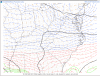
1014mb low & 1038 HP 1300

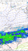
That looks fantasticHrrr has intense snow bands over my area by 4z tommorow and I heard that the picture means heavier snow if I'm not mistaken ? Still learning

Man if we can just get these dew points in central and northern va to work down
Sent from my SM-G955U using Tapatalk


Yes please do!!All our NC peeps save this !!! Might be the best one all winter . Congrats , take lots of pictures for us mid 40s and rain crowd
Sent from my iPhone using Tapatalk
I live in Greenville, SC - I see you are monitoring GSP radar - where are you located now? That's a fantastic vantage point!Inner weather nerd commencing....
I live in Greenville, SC - I see you are monitoring GSP radar - where are you located now? That's a fantastic vantage point!
Did y’all go to Joey’s pancake house this a.m.?Inner weather nerd commencing....
Sent from my SM-G930V using Tapatalk
depending on elevation, you *should* be in a great position - reports of mixing in Highlands/Cashiers - temp in Highlands is 34We are in Maggie Valley....havent really found a radar thats giving me good results of overhead conditions....I think mainly due to the mountains. GSP gives me an idea of whats coming.
Man if we can just get these dew points in central and northern va to work down
Sent from my SM-G955U using Tapatalk


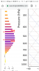
That's right. The area between the dashed lined is the DGZ (Dendritic Growth Layer). It's between -12 and -18C where snowflakes grow the more efficiently. The horizontal bars are omega, or upward motion. So seeing a max in upward velocity in the DGZ is a sign it'll be snowing pretty hard (if it's cold enough to support snow)Hrrr has intense snow bands over my area by 4z tommorow and I heard that the picture means heavier snow if I'm not mistaken ? Still learning
That's a big uptick in mby. At this point its every man for himself12z NAM Went in the wrong direction
Sent from my SM-G950U using Tapatalk

Agree and I still feel like from everything I've seen this morning and what I have seen happen in the past I'll be snow for good duration of the storm prior to any changeover.That's a big uptick in mby. At this point its every man for himself
Sent from my SM-G955U using Tapatalk
Really need that high to slide east soon so the CAD can build in

I’m hugging this model more then the nam. I believe it has a better grasp of cold air for upstate scLatest HRRR pretty much has everything but ZR. Really need these lower Tds to filter in before I buy a ZR threat...although in my experience, we usually get sleet over ZR. The upstream dews are not to shabby though, will let us wetbulb into the 20s if they make it in here soonView attachment 8902
Actually temp wise this run seemed like a step back in the right direction. Imo12z NAM Went in the wrong direction
Sent from my SM-G950U using Tapatalk
Here now!Did y’all go to Joey’s pancake house this a.m.?
Yeah tbh I did the wrong thing, didn't have time to look at details and just looked at RC's la kucaracha map and posted that LolActually temp wise this run seemed like a step back in the right direction. Imo
Personally I think your surface temps will be fine, it will be mid level temps and subsequent p-types that would be a bigger concernShould I be worried about surface temps?
Great post. IMO if the warm nose is more prominent than expected by NWS, myself, Euro, FV3, GFS, HRRR it's just blind luck. The model has displayed zero skill with this system since it's genesis in TX/OK.Our 3km nam has performed HORRIBLY with 850low placement.
Here is an example it’s literally hundreds of miles off.
View attachment 8905
3km is also very amped. It’s low is 1003 compared to 1007 at 31hrs on hrrr.
I’m not sure we can trust the nam right now.