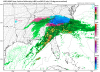
I gotta ask because I am curious. Why do these maps show snow in the Midlands of SC when there is no way it will? Thanks!View attachment 8870 Clown GFSv3 that just ran! Hug it tightly! Looks like a 20”+ lollipop over mby! Prepare for glory!
-
Hello, please take a minute to check out our awesome content, contributed by the wonderful members of our community. We hope you'll add your own thoughts and opinions by making a free account!
You are using an out of date browser. It may not display this or other websites correctly.
You should upgrade or use an alternative browser.
You should upgrade or use an alternative browser.
Wintry Dec 8-10th Winter Storm
- Thread starter SimeonNC
- Start date
I did a quick google search to see if I could find a start time for the 00z/12z runs, but I didn't find anything specific to what time it starts.
Snowflowxxl
Member
It's likely sleet or freezing rain.I gotta ask because I am curious. Why do these maps show snow in the Midlands of SC when there is no way it will? Thanks!
Nick_boynton
Member
WRF models usually just come out all at once at like a certain time ... probably around the time Euro rolls out
Nicely done. Dark Knight is hands down my fav modYou won. Sorry had too. Lol
View attachment 8868
Thank you.It's likely sleet or freezing rain.
It's probably not reaching the ground, but there's some light rain/snow returns developing across SW NC (near and SW of Asheville), extreme Northern SC, and TN right now.
Arjen Robben
Member
Realistically how much of the precip in eastern Georgia like Athens for instance is actually snow ?00z FV3 increases for everyone I believe.... N GA might be in for a suprise..View attachment 8869
Forevertothee
Member
Realistically how much of the precip in eastern Georgia like Athens for instance is actually snow ?
Freezing rain or sleet.
Sent from my iPhone using Tapatalk
Snowflowxxl
Member
Snow? Little to none probably. Mostly sleet or ice.Realistically how much of the precip in eastern Georgia like Athens for instance is actually snow ?
Arjen Robben
Member
So is the surprise you were talking about for N GA sleet and zr ?Snow? Little to none probably. Mostly sleet or ice.
Snowflowxxl
Member
Yes, could be more than expected.So is the surprise you were talking about for N GA sleet and zr ?
Forevertothee
Member
From GSP
.NEAR TERM /THROUGH SATURDAY/...
As of 900 PM EST Friday: As noted earlier, it`s taking a bit
longer for the column to saturate, so reduced pops again through the
late evening and early overnight, but increased pops in the morning
as even with light precip, the actual pops will be high. Just for
quality control, did re-run snow/ice accums, but changes are very
minimal. With this update, however, opted to issue a Winter Storm
Watch for the southern tier of counties. Confidence certainly not
high enough to go warning or advisory, and because they`ll be warmer
it looks like onset time will be later anyway, so didn`t start the
watch till 06z Sun. 18z guidance is once again trending colder at
the surface...FV3 is crazy with snowfall totals and NAM is just nuts
with ice. Certainly seems that *something* could happen in those
southern counties, even if the watch "only" transitions to an
advisory (and for the record, going from a watch to an advisory IS
an upgrade, because it`s a measure of confidence...for the policy
geeks out there the VTEC even has .UPG in it). Also, it`s possible
that accums in the area already in warnings may need to be bumped
up, but feel it more prudent to let the midnight shift take a look
at 00z models before going out with the final pre-storm forecast
Sent from my iPhone using Tapatalk
LovingGulfLows
Member
- Joined
- Jan 5, 2017
- Messages
- 1,499
- Reaction score
- 4,100
Upper level trough putting out some pretty heavy snows in western Texas right now.
LovingGulfLows
Member
- Joined
- Jan 5, 2017
- Messages
- 1,499
- Reaction score
- 4,100
Sucks for the Dallas area that the upper level trough transfers it's energy to a newly developed upper level energy near AK/TN or I think Brent and other folks in Dallas could have seen snow.
Nick_boynton
Member
Any thundersnow potential?
Snowflowxxl
Member
Low is faster for arrival on the 00z Euro, 850s colder. Would imagine a better run is coming. It really doesnt matter at this point though, short range and nowcasting time.
NBAcentel
Member
Is it me or is this storm approaching faster than forecasted ? I don't see how this would start tommorow at midnight even with Virga
NBAcentel
Member
My cousin said there's light sleet making it down in kannapolis nc, interesting radar returns developing in the piedmont
I doubt it, the air is stable over the CAD regions.Any thundersnow potential?
I was looking at the radar, it does look like the system is approaching faster. But, I just took a look at the HRRR to compare, it's about on time. The HRRR is suggesting center of low will develop at 11z Sat.Is it me or is this storm approaching faster than forecasted ? I don't see how this would start tommorow at midnight even with Virga
Cary_Snow95
Member
I'm not too sure about the FV3 snow/sleet output. It is over done for some areas. However, I would put the snow/sleet output into consideration for some areas. The 0z NAM 3KM is more realistic with it's snow/sleet output imo. Some places in NC, SC and down into GA (and possibly east of BHM, AL) that's not expecting much, could be in for a surprise.
Snowflowxxl
Member
WRF at 0z. Im off to bed. Major winter storm ahead for the Carolinas and NE GA
lolz. 14 inch area in the above map looks like this:

It's obvious scripts can be written to get rid of these stupid snow maps, pivotal does it.. and dupage..
It's obvious scripts can be written to get rid of these stupid snow maps, pivotal does it.. and dupage..
Brent
Member
Sucks for the Dallas area that the upper level trough transfers it's energy to a newly developed upper level energy near AK/TN or I think Brent and other folks in Dallas could have seen snow.
I'm not too annoyed mostly because I was never impressed with our snow chances, didn't think it'd be cold enough and it's really not
Now on the other hand if I was in Oklahoma City and had 6 inches forecast only to get basically nothing yeah I'd be beyond done lol I had actually at one point thought of chasing up there too, like yikes...
and at least it's not snowing to the south like last year, that was a nightmare that still haunts me
Ilovesnow28
Member
How much is asheville north Carolina getting... Im going to visit my family there...I'm currently leaving Tuscaloosa Alabama to Asheville and I should be there sometime early this morning... Any advice from anybody to keep me posted will help
So Shawn do you think the model is off for Columbia or could be on to something.lolz. 14 inch area in the above map looks like this:
View attachment 8876
It's obvious scripts can be written to get rid of these stupid snow maps, pivotal does it.. and dupage..
LovingGulfLows
Member
- Joined
- Jan 5, 2017
- Messages
- 1,499
- Reaction score
- 4,100
How much is asheville north Carolina getting... Im going to visit my family there...I'm currently leaving Tuscaloosa Alabama to Asheville and I should be there sometime early this morning... Any advice from anybody to keep me posted will help
Probably 10 inches on the low end side to upwards of 18 inches on the high end. Be prepared that you might be 'snowed in' for a couple of days or so.
So Shawn do you think the model is off for Columbia or could be on to something.
I think that sounding from the WRF is a cold cold rain down this way.
In all of my years of following snowstorms, I dont think I have ever seen so many people chase a storm as much as this one.
Snowflowxxl
Member
Nah, just wait till we get a board wide storm. Nobody from Alabama is even chiming in for this one. Not many GA peeps either.In all of my years of following snowstorms, I dont think I have ever seen so many people chase a storm as much as this one.
In all of my years of following snowstorms, I dont think I have ever seen so many people chase a storm as much as this one.
You missed Feb. of 2010 or December of 2010?
Forevertothee
Member

Sent from my iPhone using Tapatalk
Umm there are at least 2 or 3 Bama peeps who are driving to NC lol.Nah, just wait till we get a board wide storm. Nobody from Alabama is even chiming in for this one. Not many GA peeps either.
Ilovesnow28
Member
Jesus Christ is that's true because my mom there told me the weather forecasters there were only calling for 3 to 5 inches wow I'm only going to be in Asheville for 4 daysProbably 10 inches on the low end side to upwards of 18 inches on the high end. Be prepared that you might be 'snowed in' for a couple of days or so.
Ilovesnow28
Member
I live in Alabama and currently driving to Asheville north CarolinaUmm there are at least 2 or 3 Bama peeps who are driving to NC lol.

Safe travels. Make sure you take lots of pics.I live in Alabama and currently driving to Asheville north Carolina
It's possible some areas in Asheville, NC could receive 2 feet of snow.How much is asheville north Carolina getting... Im going to visit my family there...I'm currently leaving Tuscaloosa Alabama to Asheville and I should be there sometime early this morning... Any advice from anybody to keep me posted will help