Jon
Member

Hmmm
Sent from my iPhone using Tapatalk
I have a hard time Alabama will experience anything.All of that snow in NE Alabama is ice right?
I don't care how many vertical levels the NAM has, if it isn't handling the setup properly what's the point in looking at its warm noses? Also, in the January NC snowstorm this year, the 24 hour Euro basically nailed the snow distribution and outperformed the NAM and the other high resolution guidance. I certainly would never lean towards the NAM anything (profiles or pattern) when it isn't in agreement synoptically with the Euro and EPS first.And there you go, the NAM gets better. And matches up pretty much with the Euro and FV3.
Yeah so far just a chilly miserable cold rain for us Alabama folks as usualI have a hard time Alabama will experience anything.

Yes, and you have to know when to walk which dogNAM and CMC nailed the December storm last year, while the GFS and especially Euro whiffed like crazy. Every dog has his day!
")
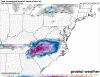
Probably mostly sleet and zr in there. Also could be a little snow further north. I'll not be stupid enough to think it will verify but I'm not sure if it is too warm since 30 mph gusts are going to blast down here Saturday night. That'll speed up the air flow for sure.This will not verify...View attachment 8860


To follow up on this, I went on pivotal to get exact qpf amounts. From the time RDU switches over to plain rain on the Nam, about .1 additional qpf falls. This is next to nothing. For the entire storm RDU sees about 1.8" of frozen qpfI'm really starting to think that when models show central NC flip to rain it's really more of a drizzle. I've seen countless times where you go from heavy snow to sleet and when the rates drop you get a light drizzle. That looks like the case this run. Once we lose the rates we lose frozen precip... in reality it could just be precip cuts off and lingers slightly as the low pulls away
That's 18zLooks a bit cleaner than the horrible TT map.
Kuchera:
View attachment 8862
10:1
View attachment 8863
Imagine that with favorable surface temps....Wowzers!!!
Hmmm
Sent from my iPhone using Tapatalk
Can't get much better than that
Hmmm
Sent from my iPhone using Tapatalk
The HRRR looked very borderline here too with line riding all the way down to just above the surface. Degrees matter every way.Seems like forecasted soundings are so borderline than any map we have witnessed seems probable.
I agree with this. It's going to be fun to see where we actually are late Saturday and early sunday in reality.Seems like forecasted soundings are so borderline than any map we have witnessed seems probable.

I'd say so. 8 inches of snow with some sleet and a little freezing rain. That would be wild.
If we could miraculously get surface temps around 29-30 this could get fun!!I'd say so. 8 inches of snow with some sleet and a little freezing rain. That would be wild.
I think people are exhausted!This place is dead..
If they are exhausted now just wait until Monday !I think people are exhausted!
I hope your on for some good snowI agree with this. It's going to be fun to see where we actually are late Saturday and early sunday in reality.
Sent from my SM-G955U using Tapatalk
It def put us back into a better situation initiallyWe need a BOOM. Come on, GFS!