• Hello, please take a minute to check out our awesome content, contributed by the wonderful members of our community. We hope you'll add your own thoughts and opinions by making a free account!

Wintry Dec 8-10th Winter Storm

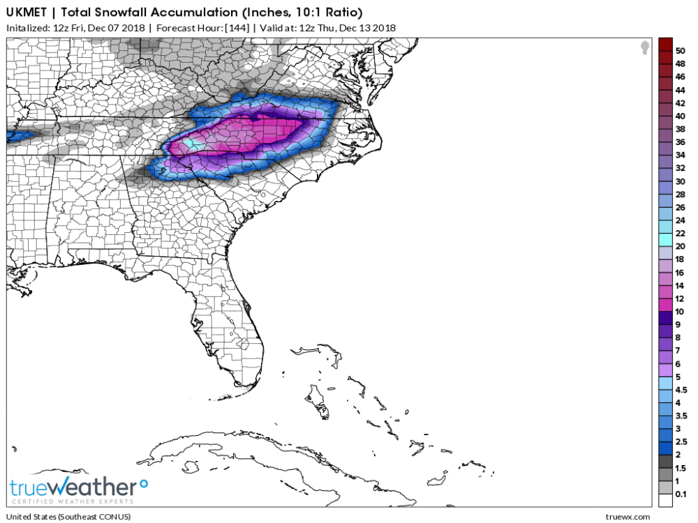
If you remember when he was at fox Carolina. He was really accurate and more times then not he was right. I stopped watching Fox Carolina when he left
I would ---- a brick if I woke up to 7 inches on Monday. I’m thinking that line shifts north and I end up with his predictions for Greenwood. We just always get shafted down here man. I’m so used to it by now yet somehow surprised everyone it happens. Which is 19 out of 20 times
 
Andy is going to bust big because of the warm nose I think. We shall see.
 
Yeah I love the FV3
8976e7f61de18d2d40635f31afa0cc41.jpg


Sent from my SM-G950U using Tapatalk
 
Andy did very well with the March 2009 storm. That is when I first started following him. He tends to be bullish of course and as others have said, since he is no longer a met it does not hurt him.
 
Andy did very well with the March 2009 storm. That is when I first started following him. He tends to be bullish of course and as others have said, since he is no longer a met it does not hurt him.
One of his last winters at Fox Carolina he went very bullish on a snow storm saying 6-8 inches and we got nothing. The snow weenies were mad and that is why he left. I am amazed CJ has survived as long as he has with his busted calls.
 
UK is a furnace in the mid levels for RDU.
It's been that way for us. I think we have a pretty good idea where the bulk of the snow will fall now. Biggest questions back this way are what is the dominant ptype? And will the bulk of the event be frozen?

It's a shame that the majority of 12z models are ticking back north now. But I guess that's usually what happens as you move in.
 
UK is a furnace in the mid levels for RDU.
How reliable is the UK snow map compared to others? This would be good for my area if it's not ice.
 
It's been that way for us. I think we have a pretty good idea where the bulk of the snow will fall now. Biggest questions back this way are what is the dominant ptype? And will the bulk of the event be frozen?

It's a shame that the majority of 12z models are ticking back north now. But I guess that's usually what happens as you move in.
Sorry man, I hoping you at least score some good sleet accum. But even that I think sets up near High Point. I’m hoping models hold steady and keep the warm nose primarily around Asheville to Statesville...but plenty of time for further northward movement unfortunately.
 
Anyone see the GEFS yet? Haven't seen it posted anywhere.
 
How reliable is the UK snow map compared to others? This would be good for my area if it's not ice.
It has been steady. That last run started to broaden out those colored areas outside of the core which is a good sign imo. Euro should come in similar. With that said I would gradually knock numbers by 1/2 to 1/3 as you get down into that lighter purple transition zone beneath the core
 
GEFS went north some...which matters if your on the southern extent.
 
Something knowone is talking about. While all the snow will be so much fun. The models show probably very heavy rain Thursday through Saturday next week. Areas that’s seen 2ft of snow will have rapid melting and major life threatening flooding possible land slides. That is a legitimate concern later in the week for western NC
 
Does anyone know about the WRF model, what range it’s effective in, and how well it typically performs? Looks like a short range model that goes out to 48 hours, but should it really not be considered outside of a shorter time frame?


Sent from my iPhone using Tapatalk
 
i don’t know that ensembles are the best tool when the system is on your doorstep. It’s time to put more weight in the mesoscale models imo the precip is there but we need to sniff out these boundaries
 
WRAL now going for 1-3" for most of Wake. I'd gladly take that, would be amazing by December standards. Hopefully we get snow and not sleet or ZR.

NWS RAH also gives a 1% chance of 12 inches or more...so you're saying there's a chance? Lol.
 
WRAL now going for 1-3" for most of Wake. I'd gladly take that, would be amazing by December standards. Hopefully we get snow and not sleet or ZR.

NWS RAH also gives a 1% chance of 12 inches or more...so you're saying there's a chance? Lol.

I think more like 3 to 6 from east to west.
 
GEFS look way more realistic for GA and SC. The southern edge of the snow total map may not even verify given a strong warm nose of mixing.
 
i don’t know that ensembles are the best tool when the system is on your doorstep. It’s time to put more weight in the mesoscale models imo the precip is there but we need to sniff out these boundaries

I think WebberWeather was saying this a while ago. One or two runs of the ensembles can skew the results greatly. Look on the latest run how there is a large swath in Georgia/SC, likely due to an outlier run with a far different track or temps


Sent from my iPhone using Tapatalk
 
Back
Top