NBAcentel
Member
It's the nam (more ice, farther north vs global models (further south, snowier
This is good for us right?They're trimming back watches/warnings out West right now like Oklahoma region cause of the track being further South in real time.
DISCUSSION...
As usual, a nice straightforward winter weather forecast. 00z
model data has continues the overall trend of a more southerly
track of the closed upper low just off the southern California
coast this morning. The main implication of this will be focusing
the heaviest precipitation more across southeast OK where
temperatures will remain warm enough for all rain through most of
the event. The low is forecast to become more of an open wave as
it tracks across northern Mexico, eventually then developing back
into a closed system as it ejects into the southern states. As
this happens, a TROWAL structure will set up with a more prolonged
period of stronger forcing extending back into northwest AR by
late Saturday. The airmass by that time should be cold enough by
then to support snow and this will be the area with the best
opportunity of seeing significant accumulating snow. Thus will
issue a Winter Weather Advisory for much of northwest AR from 06z
tonight, with some light icing potential tonight, through Saturday
night.
Winter weather potential is much less certain across eastern OK
due to the southern track and marginal temperature profile through
Saturday morning. While some potential remains for a swath of
light snow or sleet accumulation along northern edge of precip
shield, our thinking is now that accumulations will be less than
an inch for the most part, and that sfc temps will likely hover
right at or slightly above freezing and that any travel issues
will be limited. The Winter Storm Watch has been canceled, but a
short-fused advisory could still be needed at a later time.

Yeh, I feel for the folks in OKC, went from looking like a monster Winter storm to nothingThey're trimming back watches/warnings out West right now like Oklahoma region cause of the track being further South in real time.

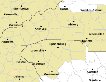
Could this trend to more snow in the upstateI had a feeling things would trend a little colder. This is going to be one hell of a storm to watch.
Sent from my SM-G955U using Tapatalk
Its definitely looking like Snow/sleet and lots of it.Could this trend to more snow in the upstate
Even south of i85Its definitely looking like Snow/sleet and lots of it.
Sent from my SM-G955U using Tapatalk
Oh I hope soCould this trend to more snow in the upstate
Could be ice down that wayEven south of i85
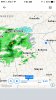
What is this??? Is this rain already coming?? Im not prepared...needed to get up dry wood and barnyard preps...

What about Anderson countyMy hope not a prediction. Just what I hope happens and it seems realistic. If everything comes together I’m hoping for 5-8 inches in upstate sc. Oconee Pickens Greenville Spartanburg counties
I would think Anderson could get in on the snow. Probably not as much but if models continue this south trend well you never know. Regardless though Upstate South Carolina will not see all snow. It will be snow sleet freezing rain and rainWhat about Anderson county

Very telling for sure. I wouldn't be surprised if it get suppressed a little more as well. Mainly because the H5 energy looks a little more sheared out. IMHO thats a great thing12z Model suites today might be very telling, interesting anyway will be curious to see if the South trend continues. I'm not at all worried about suppression but having it suppressed about 48 hours before go time is perfect IMO
Sent from my SM-G950U using Tapatalk
Yeah this thing is going to end up colder than modeled IMOVery telling for sure. I wouldn't be surprised if it get suppressed a little more as well. Mainly because the H5 energy looks a little more sheared out. IMHO thats a great thing
35° with 30° dew point and light sprinkles in Dahlonega, GA right now. The band on radar is not all virga.
Sprinkling in Franklin Co. GA North of 85 at present. DangThere has been rain reaching the ground in north GA
As of 9z, HP is situated over MO at 1036mb and our SLP is 1013mb heading towards the Baja California.
https://www.wpc.ncep.noaa.gov/html/sfc-zoom.php
https://www.wpc.ncep.noaa.gov/archives/web_pages/sfc/sfc_archive.php