Snowflowxxl
Member
Heard it was ICYAnyone have the 00z UK snow map or reports on how it looked?
Heard it was ICYAnyone have the 00z UK snow map or reports on how it looked?

Unfortunately, no. The temps are out to lunch and Charlotte has always been deep into the warm nose for mixing. Sure, there is a non-zero chance but like single digit chance. It’s not happening with this storm.Wow 2 feet in Charlotte on the FV3. Is that even possible?
What chance do you think the northern burbs of Charlotte have of getting a foot ? Like around Huntersville?Unfortunately, no. The temps are out to lunch and Charlotte has always been deep into the warm nose for mixing. Sure, there is a non-zero chance but like single digit chance. It’s not happening with this storm.
So Euro has the backside weather as well but is arguing temps we shall see its relatively close like others

If temps off by a degree or two more of N GA will be in a rather large predicamentHERE IS A TEMP GIF HORUS 0-114
SORRY FOR THE SMALL GRAPHIC. CAN UP LOAD A LARGE FILE ON HERE
So Euro has the backside weather as well but is arguing temps we shall see its relatively close like others
 Well hells bells! My TWC local forecast!!??
It really is amazing how we are literally an hr away from the snow/miserable cold rain line every time.06z NAM sits around 34F in this area for the heart of the event. This weekend is going to be absolutely gross here! Very cold & breezy rain.
It really is amazing how we are literally an hr away from the snow/miserable cold rain line every time.


Think Sumter could get an inch?I will take this ULL track and be happy with it for SC. It looks to give decent backside snow for a good chunk of SC/NC.
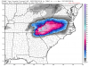
View attachment 8777
IDK, but the ice maps coming out aren't pretty for us. So far. Sumter might squeak by with predominantly rain on the main system.... still waiting on further imagery.Think Sumter could get an inch?
I am hoping for rain. I remember the last ice storm. That was awful here with power lost for quite a while.IDK, but the ice maps coming out aren't pretty for us. So far. Sumter might squeak by with predominantly rain on the main system.... still waiting on further imagery.
Kuchera shows around 0.3 - 0.5 of an inch of snow.


Here is soundings at 84 and 90 in atl area from 6z gfs as it shows precip over head. Really close to backend snow could be a mix.The backside keeps trending warmer. Really gonna be depressed if it ends up rain


GFS looks extremely suppressed guys.