From the storm on the 23rd.


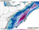
Look at that tectbook V shape accum. That reminds me of crusher bombogenesis, just diff locationView attachment 126896
I95 monster. I really could see wide spread 4-8” even back in the western Carolinas honestly. That looks too light back this way but regardless easily 1-2 feet potential with these 2 systems


I’m trying but my phone won’t upload for some reasonShare?
Eh I would say the opposite looks like many have some snow but the track is much further west on many of them giving a lot of us rain.. maybe some backside snow. This is what I’m afraid we will see more of over the coming days. As this is more climo. I hope I’m wrong thoughWow!! First storm has some nice members
I wouldn't be surprised if the first system cuts north/west and the second system (25th-26th) is the real blockbuster storm.Eh I would say the opposite looks like many have some snow but the track is much further west on many of them giving a lot of us rain.. maybe some backside snow. This is what I’m afraid we will see more of over the coming days. As this is more climo. I hope I’m wrong though
im leaning toward this tooI wouldn't be surprised if the first system cuts north/west and the second system (25th-26th) is the real blockbuster storm.


Sub 150 hours to even start getting an idea like usual.something i thought was interesting is that the amount of variance in the ensembles actually went up in how it handles the trough dropping into the plains. this is surface pressure but since surface pressure is just going to reflect what's going on in the upper atmosphere i think its a fine enough proxy. seems like there's a forecasting problem upstream that's giving the GFS a hard time, thus causing differences in the timing/position of that trough. main point- don't think any solution is off the table, this will require some patience, you know the drill, etc.
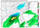
View attachment 126912


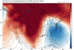
It is indeed warmer this run on the GEFS Mean, but man, this is a really good looking setup. Here is a comparison of last night's GEFS vs. tonight's. More western ridging, better -NAO couplet, and that negative anomaly over LA/MS (the storm wave) is in a really good spot (well south). On top of that, we have the big storm going up into the northeast that drags the baroclinic zone / surface cold front all the way into the Gulf and SE Coast waters, so that's a great starting point for storm #2's surface low track. The setup is there. Just got to see it all come togetherGEFS is stronger but has more WAA