• Hello, please take a minute to check out our awesome content, contributed by the wonderful members of our community. We hope you'll add your own thoughts and opinions by making a free account!

Pattern Dazzling December

Rain Cold

Pattern Cha...Loading...
Moderator
2024 Supporter
2017-2023 Supporter
Joined
Jan 5, 2017
Messages
15,864
Reaction score
43,997
Location
Raleigh, NC
It's officially time for winter! So, as we head into December, what do we see? Not a horrible look. Depending on how blocking continues to evolve, cold air could easily make it into the SE.
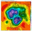
gfs_z500_mslp_nhem_50.png

The EPS is similar, FWIW.

eps_z500_mslp_nhem_50.png

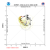
I checked the MJO and the ECWMFMFMF (GFS similar) shows it hitting a wall at P8, sending it into the COD for a quick loop.
ECMF.png
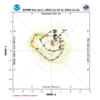
The BOMM is much more robust, but it has been overzealous the past few years, so I would discount it.
BOMM_BC.png

Models continue to show trough bases cut off, forming ULLs in the eastern Pacific. The evolution of these will impact ridging along the west coast. This will obviously be worth watching.

Anyway, it doesn't look too cold for the SE over the next couple of weeks, which is honestly not something to worry too much about. With the right blocking evolution and a little help out west, it won't be hard to get cold here.

The SPV is not too strong as we move into December, which is good. All in all, things could look and have looked a whole lot worse as we transition into meteorological winter.

Happy December!
 
Last edited:
that look also could eaisly keep most of the cold locked up in central canada regardles of the mjo
It could. But the good news is, so far at least, we haven't seen a lot of evidence for a sustained torch or icebox through the fall. It's not a stretch this year to favor more frequent bouts of blocking, which should help us get cooler at times.
 
It's officially time for winter! So, as we head into December, what do we see? Not a horrible look. Depending on how blocking continues to evolve, cold air could easily make it into the SE.

View attachment 124107

The EPS is similar, FWIW.

View attachment 124108

I checked the MJO and the ECWMFMFMF (GFS similar) shows it hitting a wall at P8, sending it into the COD for a quick loop.

View attachment 124109
The BOMM is much more robust, but it has been overzealous the past few years, so I would discount it.

View attachment 124110

Models continue to show trough bases cut off, forming ULLs in the eastern Pacific. The evolution of these will impact ridging along the west coast. This will obviously be worth watching.

Anyway, it doesn't look too cold for the SE over the next couple of weeks, which is honestly not something to worry too much about. With the right blocking evolution and a little help out west, it won't be hard to get cold here.

The SPV is not too strong as we move into December, which is good. All in all, things could look and have looked a whole lot worse as we transition into meteorological winter.

Happy December!
One thing that continues to be consistent is building up a lot of cold air in Canada and a fairly decent snowpack down into the northern Plains to the Great Lakes. If the strong blocking can develop, we could see some stuff happen once we get into the middle 3rd of the month… even with a neutral to slightly negative PNA. If we have learned anything these last several years, the MJO is the main driver of things… even if doesn’t go completely into phase 8, we at least need it to stay low amped… this high amped phase 7 we’re going into is what’s driving the milder air the next 10 days or so
 
MJO has routinely shown to be the driver of our weather here. When it went into low amp phase 7 and COD last year we saw a PNA+ and got snow. That will likely have to be the case going forward. Until the MJO no longer shows that it is the most important piece to our winter weather chances, I’m not going against it.
 
MJO has routinely shown to be the driver of our weather here. When it went into low amp phase 7 and COD last year we saw a PNA+ and got snow. That will likely have to be the case going forward. Until the MJO no longer shows that it is the most important piece to our winter weather chances, I’m not going against it.
Let’s also remember… the further we get into December, phase 7 becomes less and less of a bad thing.
 
I don’t want to try to “thread the needle” all winter. I just want a sure fire pattern where it’s gonna snow, we just don’t know how much.
 
I don’t want to try to “thread the needle” all winter. I just want a sure fire pattern where it’s gonna snow, we just don’t know how much.
That’s the thing though… we’re in the south so there’s no guarantee in any pattern no matter how good all the indicies look. We talk so much about how important a +PNA is, but as I was mentioning the other day, two of the three biggest snowstorms I’ve personally gone through here occurred with a -PNA.
 
That’s the thing though… we’re in the south so there’s no guarantee in any pattern no matter how good all the indicies look. We talk so much about how important a +PNA is, but as I was mentioning the other day, two of the three biggest snowstorms I’ve personally gone through here occurred with a -PNA.

You should take a look at Ollie’s chart. Pna is by far the most important aspect in receiving winter storms.


Sent from my iPhone using Tapatalk
 
That’s the thing though… we’re in the south so there’s no guarantee in any pattern no matter how good all the indicies look. We talk so much about how important a +PNA is, but as I was mentioning the other day, two of the three biggest snowstorms I’ve personally gone through here occurred with a -PNA.
That's what I said the other day. A slam dunk pattern doesn't exist here for snow. Best thing to do is hope for a pattern that can sustain cold to give you a wider window to thread the needle. It's very hard to get snow outside of the mtns, especially south of 85. But usually we manage to get a few chances and a couple usually work out.
 
You should take a look at Ollie’s chart. Pna is by far the most important aspect in receiving winter storms.


Sent from my iPhone using Tapatalk
I’m not discounting that chart, but all I’m saying is that we’ve definitely seen a number of significant winter storms over the years when the PNA wasn’t favorable. We’ve also seen plenty of times over the years when we had long stretches of a +PNA were the storm track was so so suppressed that all we ended up with was cold and dry. Do we prefer +PNA? Of course, but to say that not having it completely kills winter weather chances just isn’t the case.
 
You should take a look at Ollie’s chart. Pna is by far the most important aspect in receiving winter storms.


Sent from my iPhone using Tapatalk
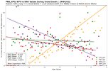
Yes, while true you can get snowfall during any index, having a +PNA significantly increases the chances of seeing snow. A PNA value less than 1 decreases the chance of snow to 5% or less. I'm currently finishing up a graphic that visualizes each index correlation to snowfall in the US as a whole. I will post that when finished.66AA3A64-E93E-4588-A173-519E0676915D.jpeg
 
Yes, while true you can get snowfall during any index, having a +PNA significantly increases the chances of seeing snow. A PNA value less than 1 decreases the chance of snow to 5% or less. I'm currently finishing up a graphic that visualizes each index correlation to snowfall in the US as a whole. I will post that when finished.View attachment 124113
This is cool. Can you explain the Y axis?
 
This is cool. Can you explain the Y axis?
Sure, I rounded each index value with snow (PNA, NAO, EPO, WPO) to 1 decimal place, and did the same for indexes without snow. I then found the percentage that a particular value produced snow by dividing the total number of snowy indexes by the total non-snow indexes. For instance, when looking at the PNA value of 0.3, there were 100 times that there was snow at that value, and 1000 times there was not. 100/1100 gives me a 9% rate of snow falling at that index value.
 
  • Like
Reactions: ajr
Yes, while true you can get snowfall during any index, having a +PNA significantly increases the chances of seeing snow. A PNA value less than 1 decreases the chance of snow to 5% or less. I'm currently finishing up a graphic that visualizes each index correlation to snowfall in the US as a whole. I will post that when finished.View attachment 124113
It’ll be interesting to see what the closest thing is to the “absolute lock” can’t miss pattern. I think I’ve read that at least for NC in January, that a phase 8 MJO, -NAO, +PNA combo produces a winter storm outside of the mountains 60% of the time. I’m sure that it’s different based on what time of the winter it is.
 
It’ll be interesting to see what the closest thing is to the “absolute lock” can’t miss pattern. I think I’ve read that at least for NC in January, that a phase 8 MJO, -NAO, +PNA combo produces a winter storm outside of the mountains 60% of the time. I’m sure that it’s different based on what time of the winter it is.
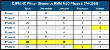
Yeah, I’m grabbing a bunch of data for my gridded snowfall analysis, which I included the MJO. I’m interested to see if I can calculate that. However, Eric Webb already did a bit of that analysis. Phase 7 is the snowiest index in January, but not a lock by a long shot.
231F898B-31FE-4543-935E-8394FD2117E1.jpeg
 
Yeah, I’m grabbing a bunch of data for my gridded snowfall analysis, which I included the MJO. I’m interested to see if I can calculate that. However, Eric Webb already did a bit of that analysis. Phase 7 is the snowiest index in January, but not a lock by a long shot.
View attachment 124114
Thanks… interesting that we’ve seen phase 7 also produce the most storms in December as well. I’m assuming that those happened with a low amp MJO because a higher amp would contribute to milder periods like what we’re going into now.
 
Back
Top