This is like getting front row tickets to a concert but not knowing who the band is yet. I never dismiss day 7 runs because even though there's wild swings one will be close to how it plays out.Yeah, it does seem the five-day disappearing act is real. It's almost like a day 7 model run is better than day 5.
I'd love to be wrong but I'd lean Euro/Ukie with 1st system, probably inland too warm for most except higher elevation. I'm concerned the impressive cold press after will suppress 2nd system but NW shifts, historically, are more doable then SE one's. We shall see
This pattern has legit big dog potential around-just after Christmas.
The overall window in/around the Holidays-last week of Dec has certainly felt about right to me from a large-scale perspective & certainly fits in general with the prototypical La Nina winter evolution, as well as the analogs that have been discussed for a few weeks now (e.g. Dec 2010)
Big arctic cold front comes down in the days prior, firmly establishing a nice, deep-layer cold air mass & suppressing the baroclinic zone to the coastal SE & E Coast, where a trailing wave can take advantage + throw moisture back into the cold air. -NAO downstream slows the wave down & encourages it to cyclonically break/amplify underneath >> strengthening any would-be winter storm, while the +PNA helps suppress the storm track down into the southeastern US.
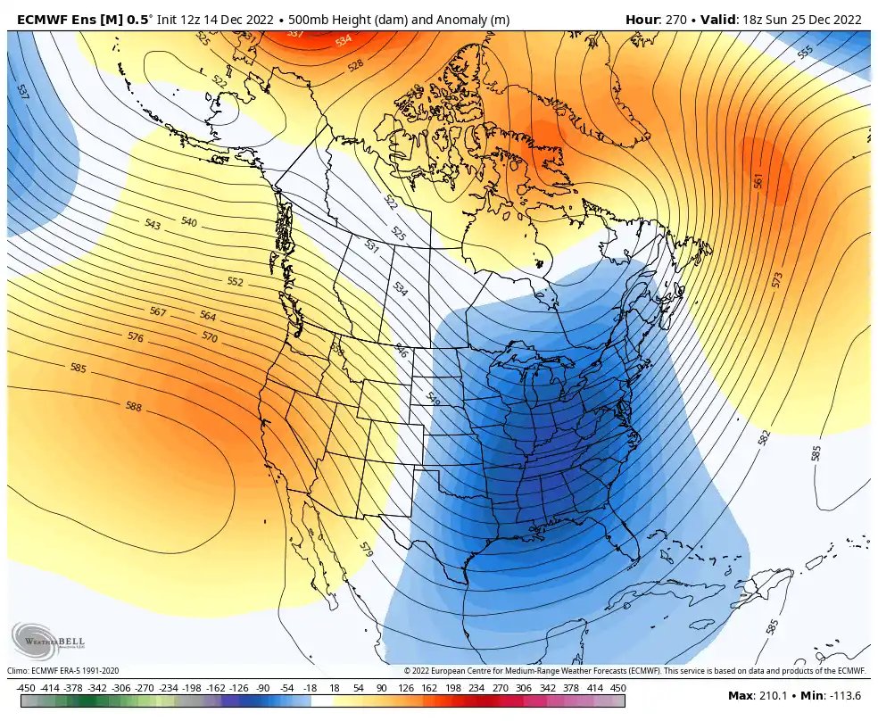
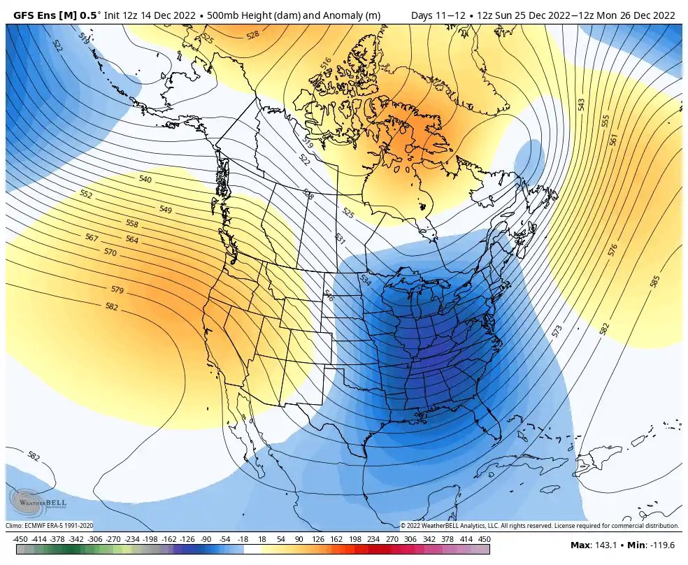
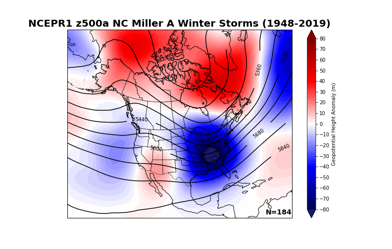
Today's 12z EPS & 12z GEFS means show a classic Miller A/coastal cyclone snowstorm look in the Carolinas, w/ the mean trough anchored in/around the TN Valley, west-based -NAO, & +PNA. Heck, we even have the ridge north of Alaska like the composite does.
Color me impressed.
Another intriguing climatological tendency I've noticed in reanalyzing storms like this, in the absence of a strong (often El Nino-induced subtropical jet) to increase available eddy potential energy (& strengthen + tuck in the low even closer to the coast >> allowing warm noses aloft to change snow to rain for those in Piedmont & Coastal Plain), these Nina Miller A storms tend to be historically kinder to folks around RDU & points east in the coastal plain & eastern piedmont of NC.
![]()
![]()
![]()
As Fro mentioned earlier, it's a good mean overall (up to 384) most of the change comes from after Christmas before New Year's. What looks like progress is my circled area. Seems like more solutions are favoring a miller a type of track with the mean increases in this area.
0z vs 6z
View attachment 126947
I’m waiting on a explanation other then “globals lose the storm only to bring it back”Some people just can’t hack it.
I think the whole “shows up, goes away, and comes back” phenomenon pertains to systems that show up, go suppressed, then Nw-trend their way back into play. Haven’t really seen it happen a lot with cutters.. though it can happen, especially in a La Niña year where models are more prone to a progressive bias.This is like getting front row tickets to a concert but not knowing who the band is yet. I never dismiss day 7 runs because even though there's wild swings one will be close to how it plays out.
The GEFS is kinda following along as well. First system is done for us. imoJust took a peek at the EPS trend, it’s not pretty, let’s hope we reverse back at 12z, but dang it’s something if the UKMET takes a win, cold is gonna come but we’re losing cold out ahead due to vortex holding back/us not getting a vortex out ahead to get us cold prior to the system View attachment 126953
this is mostly an issue for the 23rd system no? I’ve kind of written that off already. 95% of the time it is typically a stepping down process for a storm. First cuts or hits northeast then we get a chance under a suppressed flowJust took a peek at the EPS trend, it’s not pretty, let’s hope we reverse back at 12z, but dang it’s something if the UKMET takes a win, cold is gonna come but we’re losing cold out ahead due to vortex holding back/us not getting a vortex out ahead to get us cold prior to the system View attachment 126953
Yep, I still like the second system under cold vortex.this is mostly an issue for the 23rd system no? I’ve kind of written that off already. 95% of the time it is typically a stepping down process for a storm. First cuts or hits northeast then we get a chance under a suppressed flow
+1 Agree. Thanks for your input. After 15 years of model watching I always try to learn as much as I can and there's a lot of good knowledgeable guys like yourself on here I know I speak for a lot we appreciate it. Merry Christmas my friend hope we all score a good oneI think the whole “shows up, goes away, and comes back” phenomenon pertains to systems that show up, go suppressed, then Nw-trend their way back into play. Haven’t really seen it happen a lot with cutters.. though it can happen, especially in a La Niña year where models are more prone to a progressive bias.
No we should cancel winter even of our average annual snow is 3 inches. I want my foot of snow or else....Is anyone gonna be surprised to see future runs moderate some with core of the cold shifting a little west of where it's been showing the last two days ? We do this every single winter ....
It’s actually trending colder as it gets pushed back because the strong cutoff ridge is trending slightly south with each run and feeding the cold reservoir more and more with the backing up trend, it’s gotten colder as it’s backed upIs anyone gonna be surprised to see future runs moderate some with core of the cold shifting a little west of where it's been showing the last two days ? We do this every single winter ....
Fro we are 6 days out, it’s way too early to say that.The GEFS is kinda following along as well. First system is done for us. imoView attachment 126954
By that look we are trending to a Christmas night/Boxing Day storm. Maybe sooner. I've seen those short waves dive like an Olympian once they traverse the ridge and really crankGot to like the look on the EPS for the 2nd system, deep cold vortex still moving east, would eventually become 50/50 under retrograding -NAO, pac energy moving east associated with epac trough that would traverse through the ridge until it feels the lowering heights and starts to amp/dig,View attachment 126959
Yep. I totally get it’s far out, but there’s a huge amount of pattern support for something around that time, and it’s a very classic look for the SE, with plenty of cold air in placeBy that look we at trending to a Christmas night/Boxing Day storm. Maybe sooner. I've seen those short waves dive like an Olympian once they traverse the ridge and really crank
Depends on your location for many of us this is exactly what we want to see.Aint feeling it for system # 2. Always liked #1 and knew it was a 50/50 shot at best, trying to thread a needle, just had bigger needle eye. GFS Op is trending further off the GEFS than the Euro op is from its EPS. So thats not good and the trend aint our friend.
System # 2 ? Euro says what system.
![]()
Lol, it would be 33, but if a big dogs spits out of this pattern it will be down to Perry probably. A storm like the gfs is showing will get a lot of us usually left out. In fact, the depictions look like a good hammering of sleet, like the old days, with snow too. It changes all over run to run, but the storm is still there, and the pattern is holding well...so it could happen. Be of good cheer at Xmas, lol. Just don't want a strong storm as the heat generator will for sure give us the cold rain. It's a dance at the edges when zr/ip/ and sn are looking to join up. I hate freezing rain, but love sleet, and I'm often on the dividing line between hell and heaven...but I've seen some really good ip/sn storms down here, but some bad zr storms too. When the woods are crashing down on you, 33 looks really good. Of course, 35 miles can make all the difference, so we need some constantly reinforced cold pushing deep.Looks about right for us in West Central GA south of I-20. I can already let everyone know that the 34 degree rain is going to be miserable.
Only problem I have with this from the GFS is it's also based on a significant snow/ice pack which obviously affects those temps. Still gonna be cold but probably not that cold if there isn't said snow/ice on the groundView attachment 126960
If this verifies, I would have to think it would be one of the coldest seven day periods we’ve had in a very, very long time.
i'll be staying true to my username and spending the 23rd-30thish in wilmington so it's 1989 or 2010 or bust for me, which makes me think yeah richmond is going to get slapped@ILMRoss gets 2 feet on this run