- Joined
- Jan 23, 2021
- Messages
- 4,604
- Reaction score
- 15,202
- Location
- Lebanon Township, Durham County NC
I’m willing to walk down Western Blvd to raise funds.Member 10 costs a lot
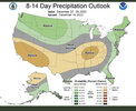
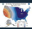
18z GFS op extracted data has a high at TDF of 20 degrees for Christmas Day.