Cary_Snow95
Member
Energy in the SW is interesting


Way too early to say, see my post aboveit doesnt look like a white christmas for anyone across the southeast but man its going to be cold


We’re really gonna need to watch for any sort of weak wave moving along the Gulf Coast during this timeframe. With that type of airmass moving into place, it wouldn’t take much to produce a light overrunning event with high ratios.This look though
View attachment 126422
We’re gonna need a new colorThis friggin GFS run is COLD
I honestly believe it ran out of colors.We’re gonna need a new color
Definitely looks intriguing. Hate to be that guy who brings up January 88, but I’m old and nostalgic. Is this in any of the analogs? I believe it also had a strong -EPO with cross polar flow, although probably not as much -NAO. It featured a very weak low with mostly baroclinic lift along the arctic front if I remember correctly.This pattern has legit big dog potential around-just after Christmas.
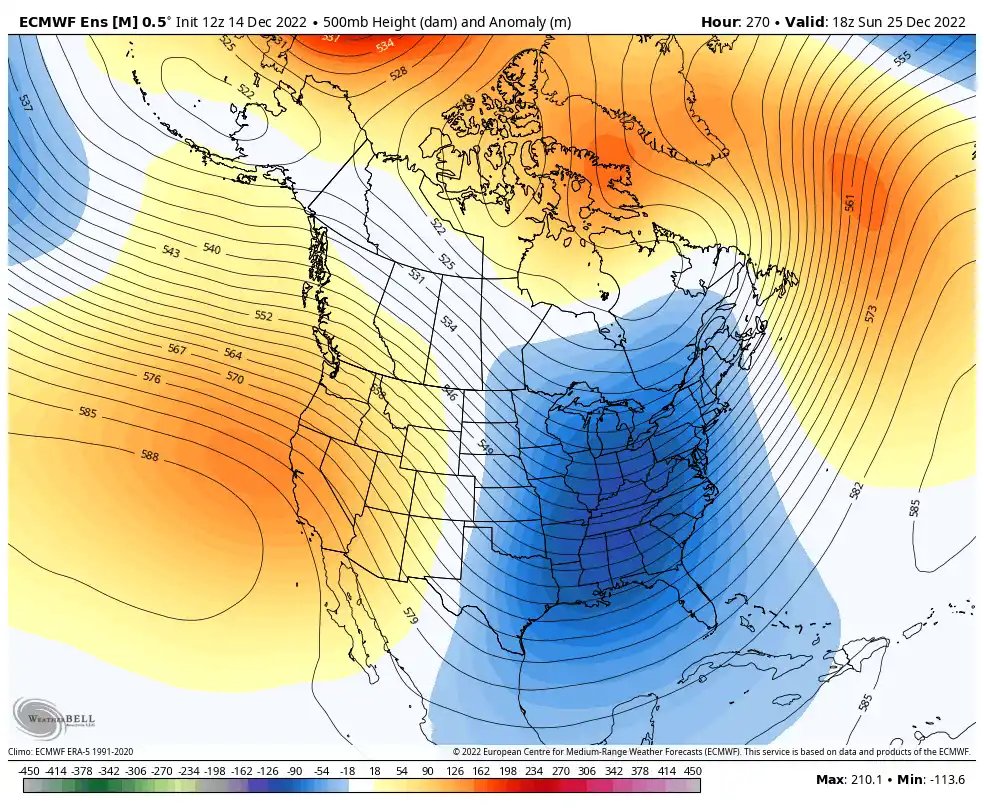
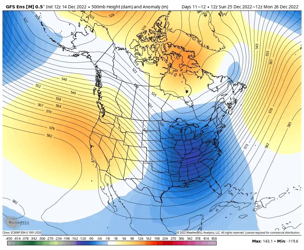
The overall window in/around the Holidays-last week of Dec has certainly felt about right to me from a large-scale perspective & certainly fits in general with the prototypical La Nina winter evolution, as well as the analogs that have been discussed for a few weeks now (e.g. Dec 2010)
Big arctic cold front comes down in the days prior, firmly establishing a nice, deep-layer cold air mass & suppressing the baroclinic zone to the coastal SE & E Coast, where a trailing wave can take advantage + throw moisture back into the cold air. -NAO downstream slows the wave down & encourages it to cyclonically break/amplify underneath >> strengthening any would-be winter storm, while the +PNA helps suppress the storm track down into the southeastern US.
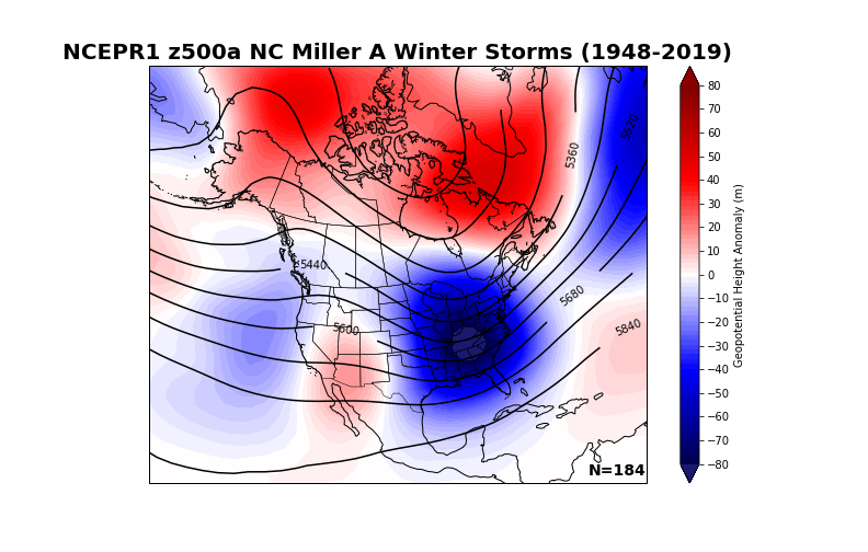
Today's 12z EPS & 12z GEFS means show a classic Miller A/coastal cyclone snowstorm look in the Carolinas, w/ the mean trough anchored in/around the TN Valley, west-based -NAO, & +PNA. Heck, we even have the ridge north of Alaska like the composite does.
Color me impressed.
Another intriguing climatological tendency I've noticed in reanalyzing storms like this, in the absence of a strong (often El Nino-induced subtropical jet) to increase available eddy potential energy (& strengthen + tuck in the low even closer to the coast >> allowing warm noses aloft to change snow to rain for those in Piedmont & Coastal Plain), these Nina Miller A storms tend to be historically kinder to folks around RDU & points east in the coastal plain & eastern piedmont of NC.
Thinking we could see some clipper action with that surge of cold airWe’re really gonna need to watch for any sort of weak wave moving along the Gulf Coast during this timeframe. With that type of airmass moving into place, it wouldn’t take much to produce a light overrunning event with high ratios.
January 1988 actually had a +NAO and +AO. Just managed to time up the coldest weather of a mild winter at the right timeDefinitely looks intriguing. Hate to be that guy who brings up January 88, but I’m old and nostalgic. Is this in any of the analogs? I believe it also had a strong -EPO with cross polar flow, although probably not as much -NAO. It featured a very weak low with mostly baroclinic lift along the arctic front if I remember correctly.
Now this is what I am talking about, ThanksChristmas Day. High temperatures. View attachment 126424
That or just some weak short wave… it wouldn’t take much to produce some overrunning.Thinking we could see some clipper action with that surge of cold air
Can you show the PNA graph that looked a lot better from a couple days ago for reference and comparison to this one??Easy to see what happened with today 12z euro here +PNA much later and much lower earlier than the majority of it’s ensembles by a few days.. huge difference here and the spread is notable View attachment 126187

Ah the old March 1980 replay
Who do we have to pay for this to happen?


I’m fairly certain that you and I both would get our sub zero lows after that.Who do we have to pay for this to happen?View attachment 126431
Is that freezing rain or heavy snow along the coast?


Probably the same here, for the 1st time since Jan 1985.I’m fairly certain that you and I both would get our sub zero lows after that.
It’s been since then too for CLT as well. January 2003 made was the closest since… 1 degree after the late January storm that yearProbably the same here, for the 1st time since Jan 1985.


