NBAcentel
Member
Bet there’s gonna be some big members 


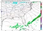
It’ll be interesting if the Euro goes to the winning trend.Looks like we’re seeing a new trend on models, this is a winning trend View attachment 126258

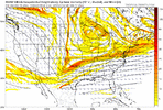
Lots of dry suppressed members it appearsQuite the reduction in the 00z GEFS mean snowfall from the previous few runs.
View attachment 126259

The 00z GEFS really only supports the northeast. We need to see more trends in the digging and a more positive PNA before we have a real shot at snow.Quite the reduction in the 00z GEFS mean snowfall from the previous few runs.
View attachment 126259


We got a long way to go with this thing in terms of knowing what we’re actually going to be dealing with.. if we’re dealing we these drastic changes run to run .. gotta stick with ensembles cause this pattern is all over the placeHuge huge huge improvement, flow is sped up in pacific so this thing is moving east
Old run
View attachment 126264
New
View attachment 126265View attachment 126266


As somebody talked about yesterday, we may be hoping for a clipper type system. I think our chances are decent with the upcoming pattern. They are hard to depict on the long-range global models. This would be something that pops up (on short-range models) within three or so days of the possible event.I've combed through everything, even 6z. The Cold is coming and staying, no doubt. We've got that covered.
The problem is we are bone dry now. Gonna take a rabbit out of the hat to get some moisture in my neck of the woods. Surprisingly even the NW flow/upslope snow looks anemic. Only silver lining is its Dec 14. So a lot can and will change. I just don't see the always advertised
-NAO helping slow the flow down Mantra helping here at the moment on the models this morning. Can't ask for better sustained Cold top down than what's gonna be on tap the week going into and after Christmas day.
All of the above is on the table. CAD/Miller B, overrunning, and sliders/Miller A are all possibleDoes this kind of pattern favor those long track winter storms that start getting their act together out in Texas? Or will we likely not see one of those with this.
Don’t forget nothing at all is also possible. Do not have your hopes too high we can fail easily even in patterns like these.All of the above is on the table. CAD/Miller B, overrunning, and sliders/Miller A are all possible
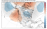
This is the EPS 5-day mean for days 8-13. We do have a -NAO here, but it's a weak one. It's hard to get these to setup just right, but the big missing piece to make it better is what I've added to the map of a big blue anomaly off the NE Coast. That's the key piece for making the -NAO rock.I've combed through everything, even 6z. The Cold is coming and staying, no doubt. We've got that covered.
The problem is we are bone dry now. Gonna take a rabbit out of the hat to get some moisture in my neck of the woods. Surprisingly even the NW flow/upslope snow looks anemic. Only silver lining is its Dec 14. So a lot can and will change. I just don't see the always advertised
-NAO helping slow the flow down Mantra helping here at the moment on the models this morning. Can't ask for better sustained Cold top down than what's gonna be on tap the week going into and after Christmas day.


Yea , Kinda what I started looking for. I figured with NW wind mtns, east Tn would have plenty of pixel dust blowing around.As somebody talked about yesterday, we may be hoping for a clipper type system. I think our chances are decent with the upcoming pattern. They are hard to depict on the long-range global models. This would be something that pops up (on short-range models) within three or so days of the possible event.
I want Complain and Take the pattern we have the last 15 days of December coming up, followed by ridging up in Alaska for January. Hard to ask for much more than that.Nothing too much to add that hasn't already been said, but I am happy to see improvement in the models overnight. It looks like they have predominantly stepped away from an active pattern. However, I always say let's check the cold box first. And the prospects of that certainly seem solid at this point.
Storms can pop at any time, and a suppressed flow, especially out in time is more preferable to me than a D10 blizzard over the SE.
It looks like the signal for blocking in the Arctic fades out in time, but the ensembles, which continue to be fairly steady, seem to hint at continued ridging up into AK, with a broad US trough.
This is why you don't abandon the Ensembles because of a couple of bad operational runs!

I've combed through everything, even 6z. The Cold is coming and staying, no doubt. We've got that covered.
The problem is we are bone dry now. Gonna take a rabbit out of the hat to get some moisture in my neck of the woods. Surprisingly even the NW flow/upslope snow looks anemic. Only silver lining is its Dec 14. So a lot can and will change. I just don't see the always advertised
-NAO helping slow the flow down Mantra helping here at the moment on the models this morning. Can't ask for better sustained Cold top down than what's gonna be on tap the week going into and after Christmas day.