NBAcentel
Member
GFS was actually faster with the extremely cold stuff then last run….

That would be a high quality cold front right thereView attachment 126157
Weirdest looking system you’ll ever see. Legit brings the freezer with it
Would their be some narrow convective fropa with that?That would be a high quality cold front right there
Dry as a bone if I had to guess with air that cold.Now we look behind to see if a storm rides into this air mass .. usually so the big cold shots like this you look for snow on the front end, a little after it’s established and on the backend for winter potentials.. this though is absolute plenty of cold air to support a winter storm .. almost too cold ?
It wouldn't surprise me, but I'm lazy and haven't looked at parameters.Would their be some narrow convective fropa with that?

Lol OP gonna trend better and ensembles going to go the other way
Kind of looks like that one in Dec 2000. Tornadoes followed by a dusting of snow. I think my high was 17 that day.It wouldn't surprise me, but I'm lazy and haven't looked at parameters.


That one has potential.. biggest question will be whether or not we can manage to get cold enough air for winter weather, either at the surface in the form of ZR or otherwise in the form of SN.. the upper air setup almost looks like a classic ZR storm across the southeast.this gefs run catching my interest in day 7 system, 50/50 low and energy with a suppressed height field, cold would be biggest issue imo, need stronger 50/50 low or more Arctic injection into it View attachment 126166View attachment 126167
Little more north and maybe a little faster then this southeast would be rockin. Fro, this is catching my interest also.this gefs run catching my interest in day 7 system, 50/50 low and energy with a suppressed height field, cold would be biggest issue imo, need stronger 50/50 low or more Arctic injection into it View attachment 126166View attachment 126167
Some of the GEFS are trying to quickly phase this system with the northern JET .. interestingthis gefs run catching my interest in day 7 system, 50/50 low and energy with a suppressed height field, cold would be biggest issue imo, need stronger 50/50 low or more Arctic injection into it View attachment 126166View attachment 126167
Really because im out to hour 168 and I don't see that.Clear trend on GEFS towards dumping in the west
We track err-thangOn a positive note I wonder what would happen if everyone in the southeast on the board was to get 30 inches of snow in one storm then would y’all be satisfied or would y’all still track snow afterwards???


Really because im out to hour 168 and I don't see that.


I don't see that as a potential west dump. Ridging in conus west as myfro pointed out

Yes sir! Great post.Getting some high ratio clippers on the GEFS lol we are far from knowing what we’re getting out of this pattern .. all I know is the cold will come
Agreed. Cold dropping into the PNW does not mean that it’s going to completely dump all out west. Personally I prefer some of it dropping out there and then spreading east and south because if it all drops east of the Rockies at once, you end up with what the GFS just did…. Bone dry cold and everything piece of energy squashed to the southern Gulf.View attachment 126177
Don't focus so much on the "blue" focus more so on the "red". The 2 run trend was to more Western ridging, which is good.


We track anything deeper than frost. Heck we even track Mega Frost. Priorities!7 day system is plenty cold enough for snow on most models for the upstate and Western NC if we get enough precip to saturate the column. Surface temps are a little iffy, but decent rates would get us to 32. Hi-Res models will look really good when they get in range,(if we can trend towards there being measurable precip Tuesday morning.)
This system definitely has potential.
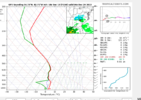
Here's a sounding from the GFS, we have well below freezing wetbulbs through the column. Just need enough precip to saturate.
That’s that 2021 western ridge type of trendThis is much much improved, air coming down is only a little less colder, but this means a more progressive pattern meaning it actually makes it here, still would be plenty cold View attachment 126178View attachment 126179


So your saying warm after ChristmasEuro is probably over amplified and too slow but the clear trend is to tilt the see saw enough that we potentially warm, cut, rain. That said we could sneak something through before this happens and I wouldn't sleep on something on the back end near or shortly after Christmas when the vortex lifts