• Hello, please take a minute to check out our awesome content, contributed by the wonderful members of our community. We hope you'll add your own thoughts and opinions by making a free account!

Pattern Dazzling December

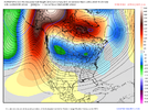
The most important thing about this system to me is that’s it the tablesetter
The cyclone next week screams "big deal" for basically the western 2/3s of the country, how it evolves probably hides the skeleton key of how favorable the holidays will be for the SE/MA.

WxSouth

14m ·

https://www.facebook.com/#
The weather is warm across the South today and next few days, from Texas across the heart of the south to the eastern Carolinas, but cold air damming in Virginia, western Carolinas continues to thwart the warm...but even there it will warm up next couple of days. Clouds and periods of rain dominate though, many more systems are slated over the next week.
So, the weather now is gloomy, rather boring across a big chunk of the region. Normal December weather, except this long cloudy stretch is a bit much to take
?

What is showing up though is, atleast in my estimation, going to be spectacular. All the signals continue to be there for a cascade of sequential Meteorological events that will thrust the central and eastern US into hard core Winter Weather over the next few weeks. A blocking ridge will build toward Alaska (this got us cold several times in October and November). A strong block around Greenland is developing as we speak and will maintain for several weeks--another cold signal for the Southeast. It's rare to get both simultaneously. I believe things are going to get very interesting down South in the next few weeks.

WxSouth
Consulting agency
Love Robert, was blessed to catch the tail end of his posting history on American. Appreciate his insight. However I think he can be a little too hype-y lately, feel like I've read a lot of "thing are about to get very interesting wink wink nudge nudge" type posts from him with patterns that end up disappointing. Not a knock on his expertise, rather just a disclaimer on this type of post.
So, the only thing this massive -NAO did was pop a -PNA?

-EPO / +PNA is 100% better for cold than -NAO.
I don't think your second sentence is necessarily wrong, I'll maintain that the main benefit of -NAOs, to me, is how it slows things down, mucks things up, and creates storm tracks that are more apt to take advantage of any cold air.
 
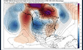
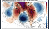
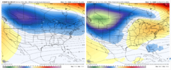
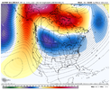
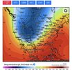
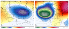
I know some folks have been losing their minds over this, but this is not exactly a super warm looking pattern next week, w/ the mean 500mb ridge near Baffin Bay. You always run the risk of getting cold air damming when your ridge is that far north & there's a trough axis over the south-central Plains.

I guess some people may have to find out/be reminded the hard way that -NAO/-PNA is usually riddled w/ CAD, ready to sneak up on you inside the medium range and spoil big warm-ups east of the Apps.

gfs-ensemble-all-avg-namer-z500_anom_5day-1256800.png

ecmwf-ensemble-avg-namer-z500_anom_5day-1235200.png
 
I absolutely agree with you. However we would’ve had 3 massive storms in January if we would’ve had a -NAO. But it just shows you. Even with a +NAO we got snow three straight snow events because of a +PNA


Sent from my iPhone using Tapatalk

It got cold last January, and it worked well to get us several threats. But that pattern in January was ridiculously progressive. So many vorts would come down the pipe along the rockies and just flatten, could not deepen and most of the threats in MBY were wiffs. That's the problem with PNA only patterns..... and it shows it's much more nuanced then just having one teleconnection on our side.

But I tend to agree in principle that the last 2 years, -NAOs have not done us any favors in regard to getting us cold. Sadly in the SE, we really need a blend of both the pacific and the atlantic co-operating IMO.
 
Last edited:
Then there's Larry the cable guy!

Larry Cosgrove

toroSsepdn58uf50c3i5a1ict46u6llh1f1t8im01aug93tc706m83109hil ·

A turn toward a colder, snowier forecast for the lower 48 states.
You could tell if you read my remarks yesterday (about the general delay in a pattern change) that I was more than a little concerned by the lack of numerical model response to the return of Arctic air into the USA. Well, lo and behold, the 0z and 6z forecast series mostly made me smile. Of course, the GFS guidance continues to live in its own chaotic, overkill warmth world. But looked at collectively, the presence of high-latitude blocking signals and an active southern branch storm track is quite apparent in much of the nation.
It is easy to see the architect for the shift to a more definitive winter weather pattern. A storm complex in between Hawaii and the Aleutian Islands will pump up ridging into Alaska and western Canada, while at the same time eject energy into California by Sunday. The resultant low pressure will be immense, intense, and proceed to buckle the jet stream in North America by the time it reaches the Quebec Eastern Townships around December 17. besides setting up severe weather threats in Dixie and the Ohio valley, the broad, cold cyclone will bring the snow line further south.
When all is said and done, we have that high-latitude compound blocking ridge scenario (Alaska, northern Canada, Greenland) and active southern branch storm track (Baja California, Texas, along or off of East Coast) working in combination to give locations to the right of the Continental Divide a shot at significant cold, ice and/or snow. Using the analogs to this pattern suggests an abrupt January 9 - 21 Thaw below the Canadian border, then a return to winter mayhem in the U.S. in the last third of next month.


+6


45You and 44 others

10 comments
5 shares
 
So different than last year where we had such a progressive pattern. The blocking pattern really pushes around key features and the physics in the models depicts various different scenarios from run-to-run. No matter how it turns out, the potential is there for a major, slow moving storm. Fun times.
 
Last edited:
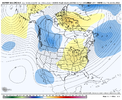
This is really a good snapshot of what has been the prevailing pattern the past 20 years; with 2009-10 being a notable exception.

318589739_10167210268010235_2760487268008769954_n.jpg


The pacific has really been in control with primarily a trough in the west (-PNA) over that time period and we just don't see prolonged troughs in the East anymore like we did in the 70s-90s. It has become so hard to get cold East of the Apps as it seems were almost always on the fringe. But even Western NC, like Boone for example, doesn't get nearly the cold and snow they used to. Hopefully we'll see cyclical pattern changes that lead to more positive PNA and negative NAO in the near future.
 
Back
Top