I was just translating the Cold Rain vibe, I'm good with the pattern, haha. CR always remains balanced, we need thatGrit with the quote of the day:
"We keep setting the table but are we ever gonna get to eat":: LOL, my thoughts exactly. Hopefully this week of Christmas and week after Start Time doesn't get kicked down the road any futher.
-
Hello, please take a minute to check out our awesome content, contributed by the wonderful members of our community. We hope you'll add your own thoughts and opinions by making a free account!
You are using an out of date browser. It may not display this or other websites correctly.
You should upgrade or use an alternative browser.
You should upgrade or use an alternative browser.
Pattern Dazzling December
- Thread starter Rain Cold
- Start date
- Joined
- Jan 23, 2021
- Messages
- 4,604
- Reaction score
- 15,202
- Location
- Lebanon Township, Durham County NC
Well thats a wrap, see yall next yr.

models rushed the -NAO and its associated change but it’s happening, models rushed the pacific change but imho with the progression I still think It happens, models just being models, pattern changes are always rushed. Even last Dec-Jan’s progression was rushed.
I remember this as models were all predicting a block around New Years but it didn’t come until around the 13th right before our storm on the 16th. It seems like they are off on pattern changes by 2-3 weeks. Somewhere somebody has the data that can prove this.
Sent from my iPhone using Tapatalk

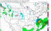
Don't discount the possibility for some changes with the Dec 18 suppressed system.. We've had our fair share of these things trending NW at this timeframe. Left image is GFS forecast 144 hours ahead of the December 2017 snowstorm.
This seems to be evolving exactly like the 2018 cold outbreak! As Jimmy alluded to earlier! The head fakes with the ‘too quick’ pattern changes on the models, almost same exact time around the holidays and then it finally happened after the New Year, and was one of the greatest week to 10 days of cold I can remember in my lifetime! So try to stay positive and ride the ensembles!
Hypsometric
Member
Just for score keeping, the UKMET has performed well at D7 recently. It also performed quite well with Ian and upper level interactions that ultimately pulled it further east that many other modeling suites were missing for some time, including most of the EPS (although a subset of it's members did pick up on that earlier).
UKMET - 12/11 | 00z run, valid: 12/18 @ 00z:

ECMWF - 12/11 | 00z run, valid: 12/18 @ 00z:

Compared to today's 12z runs....
UKMET - 12/12 | 12z run, valid: 12/18 @ 00z:

ECMWF - 12/12 | 12z run, valid: 12/18 @ 00z:

UKMET - 12/11 | 00z run, valid: 12/18 @ 00z:
ECMWF - 12/11 | 00z run, valid: 12/18 @ 00z:
Compared to today's 12z runs....
UKMET - 12/12 | 12z run, valid: 12/18 @ 00z:
ECMWF - 12/12 | 12z run, valid: 12/18 @ 00z:
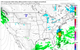
18z GFS looking more suppressed thru 138 hours, similar to ECMWF/Ukmet
Hypsometric
Member

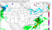
1052mb+ high rolling into the plains with a low forming in Mexico... decent look so far @ hour 159

Aw man so close

WXinCanton
Member
So close for North GA.

Brent
Member
Where do I sign up?.png")
Drizzle Snizzle
Member
Love the little random 2" snow near Peachtree City.So close for North GA.
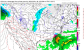
Chilly rain. Mountains could score bigly with this look. Timing is everything for everyone else.
Can't have the high pressure in Barrow and expect to get snow here, even if it is 3729 mb strong. Storms are not going to track due east along the Gulf coast and off the eastern seaboard with that kind of setup.Chilly rain. Mountains could score bigly with this look. Timing is everything for everyone else.View attachment 125860
Chilly rain. Mountains could score bigly with this look. Timing is everything for everyone else.View attachment 125860
I think this storm will continue to shift south with future runs feeling block up above.
I think this storm will continue to shift south with future runs feeling block up above.
NBAcentel
Member
Ignore the snow, the GEFS and GFS have improved at H5 from there prior runs 
As Myfrotho704 said, The 18z GFS was much improved! +PNA is stronger and the Aleutian low is further east. I know a lot of people have been bringing up February 2021, but remember that pattern had an Aleutian ridge.

No way man, you miss out on all the fun if you do that. Classic Manitoba Mauler storm here on the GFSIgnore the snow, the GEFS and GFS have improved at H5 from there prior runs View attachment 125862

A western ridging would do wonders here.Chilly rain. Mountains could score bigly with this look. Timing is everything for everyone else.View attachment 125860
I think this storm will continue to shift south with future runs feeling block up above.
Ignore the snow, the GEFS and GFS have improved at H5 from there prior runs View attachment 125862
This is a much better map for a SE winter storm than the mess at 180. The storm near Newfoundland is deepening and will suppress the height field and storm track in the east and allow high pressure to build in. There's just enough blocking to keep it from blasting out immediately. Plus, there should be real cold air to work with. The window should be fairly decently open during that period for a winter storm....unless we go back to table setting mode.

rburrel2
Member
ah, the ole 40:1 ratio powder snow!
Ah, the ole 40:1 ratio powder snow!No way man, you miss out on all the fun if you do that. Classic Manitoba Mauler storm here on the GFS
rburrel2
Member
rburrel2
Member

Nice look on the 18z GEFS!
rburrel2
Member
NBAcentel
Member
18z gefs is back to looking much much better ! Monster ridge over the Arctic 

Hypsometric
Member
18z gefs is back to looking much much better ! Monster ridge over the Arctic View attachment 125871View attachment 125872
Maybe we can claw our way back in the short-term. Even just minor adjustments made a significant improvement already.

NBAcentel
Member
Damn what a signal 


NoSnowATL
Member

Website issues are being looked into. Hold tight guys
bro i have seen a lot of gfs runs in my day keeping tabs on wilmington and i have never seen that town be in play for three coastals on one single run lmao
edit:
tired: man it would be shame if richmond got creamed while i was visiting my folks in wilmington
wired: i gotta get to wilmington as soon as possible no way im missing this
if there's a 1989 redux i levitate into heaven
edit:
tired: man it would be shame if richmond got creamed while i was visiting my folks in wilmington
wired: i gotta get to wilmington as soon as possible no way im missing this
if there's a 1989 redux i levitate into heaven
I’ll tell you what .. there are several monster GEFS members this run.. monsters
Let's have em. We've been setting the table for weeks. Let's get the payoff pix.I’ll tell you what .. there are several monster GEFS members this run.. monsters
We’ve already hit a 2 inch mean on the GEFS here in NC .. and we’re not over yet..
Pick your favoriteLet's have em. We've been setting the table for weeks. Let's get the payoff pix.


Hypsometric
Member
Not surprised. The GFS H5 setting with a negative tilt upper low/trough that grit showed would have definitely yielded more snow than it did in that run.I’ll tell you what .. there are several monster GEFS members this run.. monsters
WXinCanton
Member
Whole board pretty much wins with lucky number 7
NBAcentel
Member
Gefs probably gonna deliver the best snow mean yet when all set and done