• Hello, please take a minute to check out our awesome content, contributed by the wonderful members of our community. We hope you'll add your own thoughts and opinions by making a free account!

Pattern Dazzling December

I see people comparing this pattern to December of 2010. Was there also a -PNA during that time?


Sent from my iPhone using Tapatalk
 
I see people comparing this pattern to December of 2010. Was there also a -PNA during that time?


Sent from my iPhone using Tapatalk
There was Logan. No winters are the same, but very similar to Dec 2010 if it sets up, but imo I don't think the -nao has staying power as was the case in dec 2010-early Feb then it finally broke down.
 
All but one day had a -PNA that month

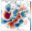
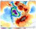
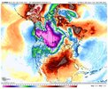
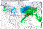
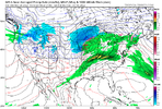
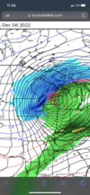
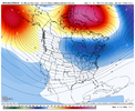
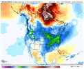
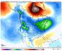
Dec 2010 had a stubborn Aleutian ridge and PNW trough and a big -NAO block, which in any other normal circumstance isn’t great for us if you get rid of the -NAO. but it’s different because the deep -AO/-NAO. Here’s how it compares to modeled solutions with and also 2018 which is similar as well. IMHO this is a “handoff” pattern. You feed energy from out west and then it goes under the block, and amplifies, which feeds the Atlantic trough/50-50 low and amplified it. It’s Not a strong -PNA being modeled at all, but one that rather keeps a active pattern going 20DA1154-BCAC-4DB0-8E0A-FA774FD60C8B.jpegFD2DF586-9139-411D-BA88-B6EA26081507.gif4F4D23F3-AFA0-4DB7-99DD-531E8E3A8F67.png1AC37783-3E1F-4CB2-9590-2C32D3B94CCC.png
 
Last edited:
Dec 2010 had a stubborn Aleutian ridge and PNW trough and a big -NAO block, which in any other normal circumstance isn’t great for us if you get rid of the -NAO. but it’s different because the deep -AO/-NAO. Here’s how it compares to modeled solutions with and also 2018 which is similar as well. IMHO this is a “handoff” pattern. You feed energy from out west and then it goes under the block, and amplifies, which feeds the Atlantic trough/50-50 low and amplified it. It’s Not a strong -PNA being modeled at all, but one that rather keeps a active pattern going View attachment 124150View attachment 124148View attachment 124147View attachment 124149
and this is the type of a pattern that can and has produced a number a winter storms even with the negative PNA… it’s probably would not work for areas of the Deep South, but could definitely work for places like northern GA, AL, and most of the Carolinas
 
With a -PNA, it’s always ok to be skeptical, as we have seen with experience, looks like mid December during the strong -NAO it’ll hang around -0.5 to -1 sigma, as long as it stays this weak, it won’t be to much of a PITA and could help with feeding us more activity. Anymore and it starts becoming a problem. Anyways with the TPV lobe and its associating energy getting caught under the block in SE Canada/the NE and the Atlantic and amplifying, typically that favors confluence to be in place
 
Mild winter upcoming according to this wooly worm.
4bc2a5938ea961c38d8da0e5a8f5fd3f.jpg


Sent from my iPhone using Tapatalk
As long as just the tips are cold
 
The block in Dec 2010 was just absurd (1st image below is Euro forecast from early Dec 2010). A block of that nature can just overwhelm the North America pattern and take control. But that's an extreme outlier. Hopefully we can get something in the ballpark of that one, but it will be tough of course.

The good news is that the lower stratosphere is under attack and in a weakened state. Research from Simon Lee shows that a -NAO is 7 times more likely when the lower stratosphere is in a weak state. 2nd image below shows the forecast (orange line) of near record low zonal wind at the troposphere/stratosphere coupling layer at 100mb, indicating a potential weak lower stratosphere condition upcoming (the blue line is from last winter for comparison).

And in the 3rd image (loop), the GEFS forecast shows the split stratospheric vortex at 50mb, with ridging building into Greenland. This forecast of bottom-up ridge coupling extending from the troposphere into the stratosphere gives the forecast of a healthy -NAO block more credence, and with the idea that it won't be an in-and-out quick hitter.

gLBCRni.png


iTVEXxJ.gif


zZtF3E2.gif
 
As for the Pacific side pattern, it's been a bit odd so far this late fall with how the MJO has been more active and moving seemingly faster than I would expect. Based on that, it's a bit difficult to assign how much effect the MJO is having on the pattern. My guess here is that we will continue to see a La Nina-like ridge in the Central-North Pacific, extending into Alaska until there is something significant that comes along to disturb that base state. Probably the thing to look for to do that would be a big episode of Positive East Asian Mtn Torque. At the moment, it doesn't look like one is on the radar for the foreseeable future....mid-Dec may be the next timeframe for something like that to occur, with effects occurring in the weeks after of ridging moving closer to the west coast (just a guess based on the cyclical nature of those events - see red line in image below). Good news is that we aren't currently seeing low pressure setup shop over Alaska, and Canada is getting supplied with cold air.
2fmufD0.gif
 
Last edited:
-PNA/-NAO is a good way to get ice storms in CAD favored areas of the Carolinas & NE GA. The mean storm track will try to cut into the TN/OH Valley & interior NE US, and really the only way we can score a storm in the absence of a neutral to +PNA is with warm/moist air overrunning shallow low-level cold air mass. Really need to build-up some snow cover to our north to enhance low-level cold/dry pushes from the NE, and I don't see something like this becoming established until about Dec 15 at the earliest.

G1oU1WU95V.png

cd75.184.25.237.329.19.48.57.prcp.png
 
Back
Top