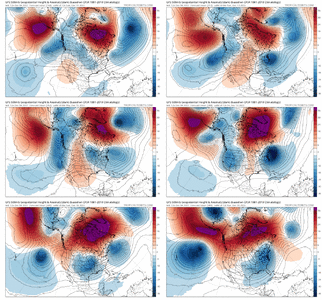
I like where it went. Stretched some higher heights into AK toward the end and looked like it was going to let that little piece of cold air rot over the eastern USThis is happening as I type this on the gefs right nowView attachment 124779

I like where it went. Stretched some higher heights into AK toward the end and looked like it was going to let that little piece of cold air rot over the eastern USThis is happening as I type this on the gefs right nowView attachment 124779


The end of that loop looks very good, like you said.I like where it went. Stretched some higher heights into AK toward the end and looked like it was going to let that little piece of cold air rot over the eastern USView attachment 124780
Yep, was always wanted the cold airmass to be 40-45 and 25-30 for lows. It’s amazing from the illustrations above, that 90% of the cold air in the world being in Europe and Asia, and the US still gets very cold!Temps 25-35 . 15-25 = dry as hell.
Yep, reminds us again how anomalous Jan 88 was! Heavy snow all day at 15-20 degrees! By Jan 1st my average daytime high is 28, will gladly share with the rest of y’all!Great point. Heck the biggest storm that I’ve personally gone through in February 2004 had a lowest temperature of 28 degrees and that was during the heaviest rates as the upper low passed over… most of that storm was about 30-31 degrees and I ended up with 19” IMBY
Www.tropicaltidbits.comHaven’t seen any posts regarding the euro. Assuming it wasn’t the best?
Sent from my iPhone using Tapatalk
Perfection!How wonderful is this
Sent from my iPhone using Tapatalk
LolHaven’t seen any posts regarding the euro. Assuming it wasn’t the best?
Sent from my iPhone using Tapatalk
Really a lot of signals on the models for something in that timeframe… again though I don’t think this is anything wintry outside of the mountains south of the Mid-Atlantic, but I think there is a low that begins setting the table for the time to follow. Something like this would certainly build up snow pack to our northView attachment 124789
Lot of energy flying around. Has this event also.

This may just be the result of continued table setters that eventually sets us up for an amazing set up around Christmas. I’m honestly fine with building snow pack to the north and continued diving pieces of energy. Not only are we setting up a better ‘fridge’ up top, we also could be helping reinforce that -NAO with the continued pieces of energy helping to keep it pumped up.Why does it gotta be hour 312 that’s so beautiful. Pacific looks great with a extended pacific jet and a ridge above AK View attachment 124790View attachment 124791

Hope it happens againI just now realized that today is the 20th anniversary of one the worst ice storms ever to hit the Carolinas. Everyone that went through that will always remember the sounds of trees snapping and power transformers popping. I was living in Concord, NC at the time and after a really quick 1/2” of sleet/snow, precip changed to light freezing rain and and it continued steady for 18 hours. Biggest ice accrual I’ve personally witnessed just a bit over an inch thick.
Something else that was impressive about this storm was the temperatures. A very strong CAD that caused temperature drops of 30-35 degrees in a matter of 12 hours or so before precip began. During the storm, temperatures hovered between 25-28 in my location for the entire storm. So much for latent heatingI just now realized that today is the 20th anniversary of one the worst ice storms ever to hit the Carolinas. Everyone that went through that will always remember the sounds of trees snapping and power transformers popping. I was living in Concord, NC at the time and after a really quick 1/2” of sleet/snow, precip changed to light freezing rain and and it continued steady for 18 hours. Biggest ice accrual I’ve personally witnessed just a bit over an inch thick.
Usually this is the case, the very cold air is too dry to produce winter precipitation and by the time the next system arrives, the temperatures are too warm to produce any thing but some ice at the onset. I do remember when I was a teenager the March 2, 1980 storm that blanketed Eastern North Carolina with some of the most impressive snowfall totals ever seen there. I was living in Eastern Wake County then and the high temperature that day at my location on the bulb thermometer that day was 17 degrees. I ended up getting around fifteen inches of snow out of that storm. That and the January 24-25 snowstorm in 2000 are two storms I will never forget. Good memories for me!It's honestly better that it won't be super cold due to the fact that the coldest patterns tend to be dry.
If you want snow, you want it cold but not too cold.
Sent from my LM-Q730 using Tapatalk


The next wave behind this one is dropping down farther south and looks wintry
Sent from my iPhone using Tapatalk
The next wave behind this one is dropping down farther south and looks wintry


If I had to bet money on what I’m seeing right now, I would still bet that KCLT ends up just slightly above average for the month. Later this week is absolutely gonna torch for several days, especially overnight as we may have 3 straight nights with lows in the 50s to near 60…. a good 20 degree + above average. Even after that, while daytime temps will be fairly close to average, we probably have to wait a week or so before getting back down to average or below on lows.I'm calling it rn, December as a whole will probably be about average for my area and NC in general, outside of the first few days of next week there doesn't seem to be much prolonged torching. And unless something goes horribly wrong, the forecast pattern change could offset the torch.
The main thing that could keep us above average is the warm lows, which seems to be a problem in recent winters.
Sent from my LM-Q730 using Tapatalk
Finally a happy Happy Hour for you
Sent from my iPhone using Tapatalk
Finally a happy Happy Hour for you
I am tired of 70 degree weather!!!!!!If I had to bet money on what I’m seeing right now, I would still bet that KCLT ends up just slightly above average for the month. Later this week is absolutely gonna torch for several days, especially overnight as we may have 3 straight nights with lows in the 50s to near 60…. a good 20 degree + above average. Even after that, while daytime temps will be fairly close to average, we probably have to wait a week or so before getting back down to average or below on lows.
Yeah that exact solution will probably never happen, but that is right at the beginning of the timeframe I think we might have potential. -AO holding strong, intensity of the -NAO relaxes slightly, PNA just about neutral, and the MJO in a good position. I know Fro likes this time frame as well.I just love seeing the colors lol. I know it’s 1000% wrong and never going to happen
Sent from my iPhone using Tapatalk
