Ron Burgundy
Member
The very rare inverse ATL snow holeATL NAM'd. I guarantee that this won't be a very likely scenario but it'd be cool if it did happen.
The very rare inverse ATL snow holeATL NAM'd. I guarantee that this won't be a very likely scenario but it'd be cool if it did happen.
Dec 23-24What time frame this is for??
.png")
I am not as confident as you. Orientation of pieces matter. We gotta see how this first storm plays out and once models get a good handle on where this storm cuts we should then look to behind it to see where the pieces end up landing. But like I’ve been saying for a month.. it’s hard to get a storm in the south even in the great patterns.Honestly, looking at the GFS, I’m fairly confident something pops in the 25-27th time frame.
That was quite a run here. Historic even View attachment 127291
Isn't the ICON warm biased? If so, then oh shoot lol.
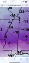
and that's at midnightWell Christmas Eve morning looks frigid
View attachment 127282
That's why I continue to beat the drum of it's not so much about patterns,I am not as confident as you. Orientation of pieces matter. We gotta see how this first storm plays out and once models get a good handle on where this storm cuts we should then look to behind it to see where the pieces end up landing. But like I’ve been saying for a month.. it’s hard to get a storm in the south even in the great patterns.

The thing about the pattern is that the right patten allows for more error when it comes to timing. We always have to thread the needle here. But a good pattern makes the eye of the needle wider.That's why I continue to beat the drum of it's not so much about patterns,
It's all about the timing.
We have literally threaded the needle in the worst patterns & got good to great results.
The opposite has happened in great patterns.
What worries me is waisting all this good deep cold.
It's quite fascinating to see such a different solution. Would be a pleasant surprise even with half those amounts since it would stay on the ground a while. Still too early to know and always good to keep our expectations in check.Dec 23-24
They are historically great for the east. ------------- kind of mentioned it may not behave like a traditional -NAO used to. I had my doubts but once again he looks to be on to somethingIs it just me or does it seem like the -NAO has done more harm that good this year so far? I may be 18 years old but I’m old enough to remember the claim so many people say that a -NAO is good for the Mid-Atlantic and Eastern Seaboard. It seems like the NAO, or at least the variation of it this year, has been detrimental for us in the South and East. The massive low 500 miles ESE of Nova Scotia caused by the negative NAO has caused buckling in the jet further back west, over us, with only mediocre heights and a subtle upper ridge nudging and grudging it’s way over us again and again. Sure, Europe has definitely seen the cold and snow and it might just be the unfavorable Pacific; but, for us here in the East this massive -NAO has done nothing but churn higher 500 mb heights up into it along the Eastern Seaboard and that looks to be the case with the 22/23 system with basically a repeat of Dec 15 in the East, just colder this time. You might think I’m a ? but what the **** is wrong with this -NAO?
Good thing is that the front seems faster on the GEFS and it's not as warm before so.

The -NAO does have a positive correlation to more snow across most of the US. However, that's only when the NAO actually blocks cold air. Often times the NAO can be manipulated unfavorable to turn into a North Atlantic Ridge for reasons like a +EPO during the first week of the month. This period looks to be unfavorable and prohibits the -NAO from developing a 50/50 low because the trough is too far into Central Canada and forces the ridge into the 50/50 region. In conclusion, most -NAOs are favorable because troughs can undercut them, but oftentimes, that's not a sure bet.Is it just me or does it seem like the -NAO has done more harm that good this year so far? I may be 18 years old but I’m old enough to remember the claim so many people say that a -NAO is good for the Mid-Atlantic and Eastern Seaboard. It seems like the NAO, or at least the variation of it this year, has been detrimental for us in the South and East. The massive low 500 miles ESE of Nova Scotia caused by the negative NAO has caused buckling in the jet further back west, over us, with only mediocre heights and a subtle upper ridge nudging and grudging it’s way over us again and again. Sure, Europe has definitely seen the cold and snow and it might just be the unfavorable Pacific; but, for us here in the East this massive -NAO has done nothing but churn higher 500 mb heights up into it along the Eastern Seaboard and that looks to be the case with the 22/23 system with basically a repeat of Dec 15 in the East, just colder this time. You might think I’m a ? but what the **** is wrong with this -NAO?

Raincold,The thing about the pattern is that the right patten allows for more error when it comes to timing. We always have to thread the needle here. But a good pattern makes the eye of the needle wider.
In this case, the pattern isn't that good at the time of this storm, or so it appears at the moment. The thing that you look for 7+ days out is to see if the right components of a winter storm pattern are on the field, not to see if the model is showing a storm. Not saying you were doing that. But the pattern is directly related to the timing aspect.
The bad news is to my eye, the 22/23 system is mostly cutters on it.
View attachment 127296
I haven't gotten to the Christmas system, but man, I'm just not feeling it. Too good to be true.
Highly doubt this or a southeast ridge. We’re about to extend the pacific jet to the point where we see the EPO go positive. Meaning less amplified pattern and a zonal pattern. No real SER but just a pacific source region, whether it’s polar pacific or warm pacific air.Either the real cold is just delayed for NC/SC or it just can't get over the mountains. Probably just delayed and perhaps modified a bit. Sooner or later the SE ridge will come into play and looking at teleconnections, probably around the 5th of the New Year


I never believed in that system anyway. I'm looking for a good cold press. Something like the ICON.The bad news is to my eye, the 22/23 system is mostly cutters on it.
View attachment 127296
I haven't gotten to the Christmas system, but man, I'm just not feeling it. Too good to be true.


The EURO is further north with the 22nd-23rd system. In the end, given where we are as of now, that may end up being a good thing as it gives room for some 25th-27th action.
It is. It's also 7 days out.Strong wave just too much tilt.

It is. It's also 7 days out.
My thinking is if we can't get the big one to dig to nearly the gulf coast for a board-wide mega bomb, we're better off leaving the door open for the next two pieces rather than blasting everything to Cuba.
Weenie hopium I know.
suppression starting to give?It’s scattered, but there is definitely some noise with the EPS in the 25-26th time frame. A couple really big members for the very Deep South.
It’s scattered, but there is definitely some noise with the EPS in the 25-26th time frame. A couple really big members for the very Deep South.

Still a lot of members with suppression and some as late bloomers. Accu on the other hand would like the one that drops a foot plus in South AL.suppression starting to give?


.png")
