It takes Western Carolinas from 40s-50s the night of the 22nd to highs in the 20s on the 23rd
-
Hello, please take a minute to check out our awesome content, contributed by the wonderful members of our community. We hope you'll add your own thoughts and opinions by making a free account!
You are using an out of date browser. It may not display this or other websites correctly.
You should upgrade or use an alternative browser.
You should upgrade or use an alternative browser.
Pattern Dazzling December
- Thread starter Rain Cold
- Start date
LukeBarrette
im north of 90% of people on here so yeah
Meteorology Student
Member
2024 Supporter
2017-2023 Supporter

I gotta say that this is even too extreme for reality. Won’t be anything close to this.
accu35
Member

This image right here tells me that there’s gonna be some snow showers in the Deep South at the arrival of the front. Look in the gulf. Baby steps towards the gfs?
If you love the weather truly you won’t even be mad at this euro solution. To witness a front like that and get to experience it will something truly remarkable!
whatalife
Moderator
WEATHERBOYROY
Member
It's not a lot, but a nice cold rain in east texas rigt now
Unfortunately for us, as with the Icon and CMC, the Christmas storm is probably dead on this run. Not that is matters either way with these shifts.
WXinCanton
Member
That's ocean effect in the Gulf pretty sureView attachment 127063
This image right here tells me that there’s gonna be some snow showers in the Deep South at the arrival of the front. Look in the gulf. Baby steps towards the gfs?
- Joined
- Nov 29, 2021
- Messages
- 42
- Reaction score
- 144
We're really not in phase 5. The MJO doesn't have any effect on this pattern
How many days or weeks does it take for the MJO to have an affect on the pattern, assuming that Euro chart was right and it were to shift into phase 4 or 5 or 6 around the 22nd & 23rd?
Euro doesn’t look very good if you’re wanting snow in the south/southeast during the 23rd system. This is getting into the range (120-168hr) where I’d like to see threats suppressed south so they have time to shift northwest (since they all do just about). Times ticking on this threat, but it’s not quite over yet.
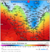
Welcome to the reality of thermal gradients in meteorologyView attachment 127065
I gotta say that this is even too extreme for reality. Won’t be anything close to this.
accu35
Member

Here’s what we didn’t have last night lol
LukeBarrette
im north of 90% of people on here so yeah
Meteorology Student
Member
2024 Supporter
2017-2023 Supporter
Oh I know just saying that there is no way there will be rain all the way up into CanadaWelcome to the reality of thermal gradients in meteorology
WAA has done crazier things my friend.Oh I know just saying that there is no way there will be rain all the way up into Canada

Regardless of no snow for the SE and most of the Eastern Seaboard, it’s still a monster. 850 circulation extends from James Bay in ON to south Florida, and the Central Plains to Nova Scotia. Euro honestly did not know what to do with the SLP after it occluded and decoupled from the upper levels while they were still not down maturing around 168-174hrs.

LukeBarrette
im north of 90% of people on here so yeah
Meteorology Student
Member
2024 Supporter
2017-2023 Supporter
Personally you’re wrong. This storm will be a middle ground solution between GFS and CMC. You can berate me all you want if I’m wrong.WAA has done crazier things my friend.
Honestly it’s not nearly as bad as I thought. Considering that the PV lobe normally trends weaker or northward with time, the threat is obviously still there in the weeds or delayed somewhat.
I'm by no means an expert on the MJO, but this pattern seems to be largely guided by the influence of jet extension associated with the -EAMT, and the blocking retrogression that has been ongoing since November. Once those influences run their courses, the MJO will likely take on more influence in early January.How many days or weeks does it take for the MJO to have an affect on the pattern, assuming that Euro chart was right and it were to shift into phase 4 or 5 or 6 around the 22nd & 23rd?
You could be correct. Working in absolutes in meteorology is not the smart route to take though. This euro run is in the range of possibilities is all I’m sayingPersonally you’re wrong. This storm will be a middle ground solution between GFS and CMC. You can berate me all you want if I’m wrong.
Not a bad trend for the 26th system. 
NBAcentel
Member
West pacific forcing/+AAM/+EAMT= jet extension we’re seeing.I'm by no means an expert on the MJO, but this pattern seems to be largely guided by the influence of jet extension associated with the -EAMT, and the blocking retrogression that has been ongoing since November. Once those influences run their courses, the MJO will likely take on more influence in early January.
a MS valley nuke instead of a MA nuke probably means the longwave trough is positions a little more favorably to get the second wave action to negative tiltNot a bad trend for the 26th system.
NBAcentel
Member
There so much energy rounding the western ridge. I’m not that worried honesty 
- Joined
- Jan 23, 2021
- Messages
- 4,604
- Reaction score
- 15,203
- Location
- Lebanon Township, Durham County NC
Cold air is honestly just run of the mill here. It is a dramatic drop but mid 30s is just not exceptional cold air for this part of the country.
This is not run of the mill by any stretch.Cold air is honestly just run of the mill here. It is a dramatic drop but mid 30s is just not exceptional cold air for this part of the country.


- Joined
- Jan 23, 2021
- Messages
- 4,604
- Reaction score
- 15,203
- Location
- Lebanon Township, Durham County NC
I should’ve qualified for our back yards. Other side of the mountains, absolutely.This is not run of the mill by any stretch. View attachment 127071View attachment 127072
Probably a delayed but not denied setup when the big low relaxes a bit.There so much energy rounding the western ridge. I’m not that worried honesty View attachment 127070
Last edited:
I am concerned about the SE Canada vortex. With a stronger cutter, the models want it to exit poleward, rather than NE into the Atlantic. Without the positioning of the 50/50 low, any wave would come down neutrally rather than positively.There so much energy rounding the western ridge. I’m not that worried honesty View attachment 127070
- Joined
- Jan 23, 2021
- Messages
- 4,604
- Reaction score
- 15,203
- Location
- Lebanon Township, Durham County NC


Going to hope this run was too extreme with the cut.
7-8 days of adjustments. We have not seen the final product by any stretch.I am concerned about the SE Canada vortex. With a stronger cutter, the models want it to exit poleward, rather than NE into the Atlantic. Without the positioning of the 50/50 low, any wave would come down neutrally rather than positively.
JHS
Member
A strong enough system can do a lot of crazy things. If I remember right back in Feb 1989, it was 33 with snow where I am and at the same time Augusta GA was around 26-27 and Columbia was right around 30 with snow. IF that low goes that far north and is strong enough it can indeed be rain into Canada.WAA has done crazier things my friend.
SnowNiner
Member
I am concerned about the SE Canada vortex. With a stronger cutter, the models want it to exit poleward, rather than NE into the Atlantic. Without the positioning of the 50/50 low, any wave would come down neutrally rather than positively.
I wonder if our blocking will do work to keep it where it needs to be....I'm still waiting for the blocking to help us with something. Perhaps by this time we don't have a true- NAO anymore. 50/50 lows don't seem plentifully modeled.
Can someone post this map but the for the great lakes ohio valley or a bigger version..I’m supposed to travel that way Wednesday and Thursday for the holidays and want to know if it will be good to go or nowView attachment 127066
Here’s what we didn’t have last night lol
Agreed, spot on. Kind of in and out. Looks like we get back to just a notch below normal within a day or 2 per euro instead of 2 notches.I should’ve qualified for our back yards. Other side of the mountains, absolutely.
Can someone post this map but the for the great lakes ohio valley or a bigger version..I’m supposed to travel that way Wednesday and Thursday for the holidays and want to know if it will be good to go or not
Besides the GFS, There is zilch upslope from the foreign suite of models
Wide range of possibilities 6-8 days out