I get reverse lollipopped? Toss
-
Hello, please take a minute to check out our awesome content, contributed by the wonderful members of our community. We hope you'll add your own thoughts and opinions by making a free account!
You are using an out of date browser. It may not display this or other websites correctly.
You should upgrade or use an alternative browser.
You should upgrade or use an alternative browser.
Pattern August Rush 2020
- Thread starter accu35
- Start date
GoDuke
Member
I get reverse lollipopped? Toss
It ain't pretty, but the bulk of the heat anomalies are up in SE Canada through the 6 week period... so it looks like same ole same ole, barring any pattern changing tropical event: 
Cad Wedge NC
Member
Boy, you sure missed that one..... Widespread heavy rainfall last night. Face it, this is not your year.Very little in the GSP CWA area and I do NOT see that changing. Including Charlotte. A quiet evening in store it looks like.
smast16
Member
3.25” of rain so far And still raining
Got 4.25” here in Colfax between 6:30 and 8.
TW
Lol. About 10 and 5 miles away and getting between 3" - 4".
I got 1" total.
NBAcentel
Member
So much Convective debris
So much Convective debris
Was just about to say the same. GSP says it should burn off. Guess we will have to wait and see.
Hard not to think at least decent coverage Wed and Thur. Friday night be tempered back by debris and stratus from the Thursday stuff. As we get into late weekend early next week think we try to slip in a MCV in the WNW flow.
Going out from that would be shocked to try to trap a baggy upper low/weakness as heights build into the Lakes and NE. All in all a much better coming 10 days than the previous 21 for some of us
I think we still see some action today. It will just be later on today into this evening. It is getting brighter and the cloud deck is thinning out a bit now. It may actually help initiate some storms due to the differential heating from this morning's debris clouds. We shall see.
NBAcentel
Member
Looking at what's going on I am a little conflicted though. Obvious sfc convergence and differential heating to our SE makes me want to say we don't see much today unless the northward moving ofbs can get stuff going. Another part of me says trough axis approaching and delayed warming keeping convection down means we get some type of loose line starting out your way that progresses east on its outflow. Tough call today to be honestGood stuff man @SD
BHS1975
Member
HRRR looks like it’s on schedule with convection back building from the east.
Sent from my iPhone using Tapatalk
Sent from my iPhone using Tapatalk
Didn't take long for temps to jump once the sun got out up 3 degrees since noon
Shaggy
Member
Soon as we got good sun it popped. Gonna get a quick shower but very little lightning just elevated thunder.
Up to 3/4” with this little complex, should be over 1” before it clears. Most fell over a 15 minute period, certainly the wettest week of the summer here so far and can tell things are starting to green up!
Shaggy
Member
Up to 3/4” with this little complex, should be over 1” before it clears. Most fell over a 15 minute period, certainly the wettest week of the summer here so far and can tell things are starting to green up!
Man there were a couple decent strikes near us that had some deep thunder. By far my best lightning and thunder I've seen this year.
Boom

.76 4.83 for the week may catch June+July soon
NBAcentel
Member
.76 4.83 for the week may catch June+July soon
Got over a inch of rain last night, welcome to
The cool kid club
? ?Got over a inch of rain last night, welcome to
The cool kid club
B
Brick Tamland
Guest
From WRAL weather
An outflow boundary is moving to the west into Johnston County and eventually Wake and Harnett Counties.We expect this to trigger more storms to develop through the evening. Tune in starting at 4PM on WRAL to see how they develop over the next few hours.

An outflow boundary is moving to the west into Johnston County and eventually Wake and Harnett Counties.We expect this to trigger more storms to develop through the evening. Tune in starting at 4PM on WRAL to see how they develop over the next few hours.
And like clockwork storms are bubbling SE and SW of CLT making that NE trajectory. Should see more development as time goes on. @Myfrotho704_ May wanna dust that camera off, Haha. I think a lot of gave up this morning.
NoSnowATL
Member
Thunderstorm outbreak north of me today. Stayed south yesterday.

I guess that means I'm the biggest loser. Lol only 7.8 since June 1st. Unless @smast16 has got me? But even he's done well lately.
.png")
?
Looks about right. Lol
Growing storm over southern Wilkes may go severe soon
3 rains in 1 day. Who broke the weather machine
4-Life
BHS1975
Member
Yeah you won’t be complaining for a while.
Sent from my iPhone using Tapatalk
NBAcentel
Member
Let’s gooo 
HRRR saysYeah you won’t be complaining for a while.
Sent from my iPhone using Tapatalk
.gif")
Shaggy
Member
Getting my 2nd storm of the day and this storm genesis is one of the best I've seen in years.
We win for a dayGetting my 2nd storm of the day and this storm genesis is one of the best I've seen in years.
Shaggy
Member
We win for a day
This thing started out as a tiny base and went full on mushroom cloud up with some smooth striations up the side. A thing of beauty.
Attachments
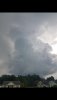
That's how it started for me earlier in the afternoon. Just one dark cloud then boom the entire sky was blackThis thing started out as a tiny base and went full on mushroom cloud up with some smooth striations up the side. A thing of beauty.
Shaggy
Member