Brent
Member


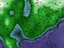
Not my fantasy. Show dews in the 70's under heavy rain!Here's a little fantasy stuff; the CFS is showing a cool pattern from day 12 all the way to early September. I'll have to see it to believe it but that would be very welcome.
Day 12 dew points:
View attachment 120370

Models: CFS - Pivotal Weather
View CFS weather model forecast map image for Precipitation Type, Rate in Continental US on pivotalweather.com.www.pivotalweather.com
Winter: "In 7 days it could be snowing or severe based on how much the trough digs"
Summer: "In 7 days if we're lucky we'll have 5h heights be under 588dm!"
get me out of this season asap
Like I said previously. The past few years we had a late start to summer with the heat not coming until Mid to Late June that ended up having the heat run well into August and into September (October 2019). This year we got back to normal where by Mid May summer was in full force. I am praying we can get back to by the end of August and beginning September we will be down towards the upper 70's and lower 80's. Hopefully by the end of September we will be towards the lower 70's.Mid-long range pattern on GFS gives hope we might get an early end to Summer this year.
It is down for an upgrade for 2 weeks.Do any ATL peeps know what is wrong with the radar, ATL?
It’s down for repairs.Do any ATL peeps know what is wrong with the radar, ATL?
It needs a new pedestal. The first one was made out of old pizza boxes and duct tape and coated in lard.Do any ATL peeps know what is wrong with the radar, ATL?
#SDrainshield
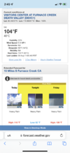
Death Valley gets higher temps and more rain than you bro ?30 day running precip total will be back below 1 inch soon. Last can kicking rain was 11 days ago, last significant rain was 23 days ago. Grass is toast where I'm not watering. Starting to see wilt in shrubs and some leaf drop in trees. Next 5 show near 0 rain chances. The front next week will have to be timed well or it'll be another dud

I'd wager that everyone on this board minus about 3 or 4 people have more rain than me since 6/1. it doesn't even make me mad anymore it's just sad and really hard to believe. I still can't wrap my head around potentially going 2 summers without over 1.5 from a single storm (will have to check the numbers to verify) especially when places 5-15-25 miles away get 2 months worth of rain in an evening
My normal precip for August is like 3.5”! That seems very moist, but we shall see!I'd wager that everyone on this board minus about 3 or 4 people have more rain than me since 6/1. it doesn't even make me mad anymore it's just sad and really hard to believe. I still can't wrap my head around potentially going 2 summers without over 1.5 from a single storm (will have to check the numbers to verify) especially when places 5-15-25 miles away get 2 months worth of rain in an evening
So, not only do they get out Troughs in the winter, they also get our summer rains now too. Great.
I believe I am one of those 3 or 4. I live in Chapin and I ended July with .9 inches and have had 2.5 inches since June 1 while the surrounding areas, (the Central Midlands) have had so much that people are complaining of the water. My last 1+ inch rainfall was May 11. People here have given up watering their lawns because we can't keep up. My lawn is at least 50% brown and there are even large trees now showing stress. I feel your pain Bud.I'd wager that everyone on this board minus about 3 or 4 people have more rain than me since 6/1. it doesn't even make me mad anymore it's just sad and really hard to believe. I still can't wrap my head around potentially going 2 summers without over 1.5 from a single storm (will have to check the numbers to verify) especially when places 5-15-25 miles away get 2 months worth of rain in an evening
